 view gallery view gallery SE10.5 km SE10.5 km
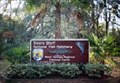
|   Bears Bluff National Fish Hatchery - Wadmalaw Island - SC Bears Bluff National Fish Hatchery - Wadmalaw Island - SC
in Fish Hatcheries Bears Bluff National Fish Hatchery is a unit of the Warm Springs Fish Technology Center, a component of the Warm Springs Regional Fisheries Center, Warm Springs, Georgia posted by:  carolina1 carolina1 location: South Carolina date approved: 09/03/2008 last visited: 10/21/2010 |
 SE11.7 km |  Irvin-House Vineyard Irvin-House Vineyard
in Wineries Irvin-House Vineyard is located on Wadmalaw Island, SC and is Charleston's only domestic winery. posted by:  JI Sandlappers JI Sandlappers location: South Carolina date approved: 01/02/2006 last visited: 10/21/2010 |
 view gallery view gallery S12.6 km S12.6 km
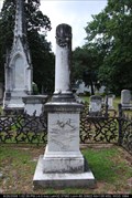
|  Seabrook - Presbyterian Church Cemetery - Edisto Island, SC Seabrook - Presbyterian Church Cemetery - Edisto Island, SC
in Broken Column Headstones Cornelia Adelaide Seabrook
Presbyterian Church on Edisto Island posted by: carolina1 location: South Carolina date approved: 08/27/2008 last visited: 08/27/2008 |
 view gallery view gallery NW13.2 km NW13.2 km
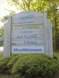
|  Edisto Nature Trail - Jacksonborough, SC Edisto Nature Trail - Jacksonborough, SC
in Public Access Lands A smaller tract of land provieds a 1.5 mile loop through lowcountry forest. posted by: ChapterhouseInc location: South Carolina date approved: 05/03/2010 last visited: 04/09/2010 |
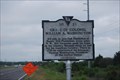
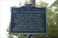 view gallery view galleryNW13.2 km |  15-1 Old Jacksonborough 15-1 Old Jacksonborough
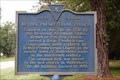
in South Carolina Historical Markers Marker 15-1 Old Jacksonborough First known as Pon Pon. Located on US Hwy 17 at Jacksonborough. Erected by Colleton County Historical Society in 1959. posted by:  mikemtn mikemtn location: South Carolina date approved: 08/19/2006 last visited: 06/20/2002 |
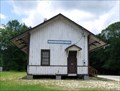 view gallery view gallery NE13.5 km NE13.5 km
|  Ravenel Depot/Ravenel, SC Ravenel Depot/Ravenel, SC
in Train Stations/Depots Located in Ravenel, SC. posted by: carolina1 location: South Carolina date approved: 09/15/2008 last visited: 01/10/2024 |
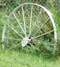 view gallery view gallerySE15 km |  Wagon Wheels - Edisto, SC Wagon Wheels - Edisto, SC
in Wagon Wheels Wagon Wheels near Edisto Beach, SC. posted by: carolina1 location: South Carolina date approved: 01/22/2009 last visited: 01/22/2009 |
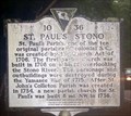 view gallery view galleryNE17.2 km | 10-36 St Paul's Stono/St Paul's Churchyard - Meggett, SC in South Carolina Historical Markers The 10-36 St Paul's Stono/St Paul's Churchyard historical marker is located on State Hwy 162. posted by: hummerstation location: South Carolina date approved: 06/07/2016 last visited: never |
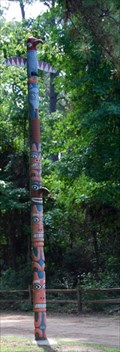 view gallery view gallery E17.4 km E17.4 km
|  Totem Pole - Wadmalaw Island, SC Totem Pole - Wadmalaw Island, SC
in Outside Wooden Display Carvings Totem Pole located at the entrance of Camp Ho-Non-Wah Boy Scout
Camp. posted by: carolina1 location: South Carolina date approved: 09/14/2008 last visited: 06/25/2010 |
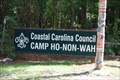 view gallery view galleryE17.4 km |  Camp Ho-Non-Wah, Wadmalaw Island, SC Camp Ho-Non-Wah, Wadmalaw Island, SC
in Boy Scout Camps Camp Ho-Non-Wah is located on Wadmalaw Island, SC. posted by: carolina1 location: South Carolina date approved: 09/10/2008 last visited: 06/25/2010 |
 view gallery view galleryE17.5 km |  St James Bethel AME Church - Wadmalaw Island, SC St James Bethel AME Church - Wadmalaw Island, SC
in Geodesic Domes 5305 Maybank Hwy, Wadmalaw Island, SC - (843) 559-2442? posted by: carolina1 location: South Carolina date approved: 09/11/2008 last visited: 06/25/2010 |
 view gallery view galleryNW17.7 km | 15-14 Pon Pon Chapel in South Carolina Historical Markers Marker 15-14 Pon Pon Chapel located at the junction of SC Hwy n64 and Road 40 erected in 1994 replacing a marker erected in 1970 by the Colleton County Historical Society. posted by: mikemtn location: South Carolina date approved: 08/13/2006 last visited: 01/30/2016 |
 view gallery view galleryNW18 km | 15-8 Bethel Presbyterian Church in South Carolina Historical Markers Marker 15-8 Bethel Presbyterian Church located on SC Hwy 64 12 miles East of Walterboro South Carolina erected by Colleton County Historical Society in 1964. posted by: mikemtn location: South Carolina date approved: 08/13/2006 last visited: never |
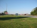
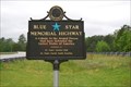 view gallery view galleryNE19.2 km |  US Highway 17S - South Carolina US Highway 17S - South Carolina
in Blue Star Memorial Highway Markers Blue Star on Highway 17S near Ravenel, SC. posted by: carolina1 location: South Carolina date approved: 04/23/2008 last visited: 12/30/2019 |
 view gallery view galleryNW19.2 km | 15-12 Battle of Parker's Ferry in South Carolina Historical Markers Marker 15-12 Battle of Parker's Ferry located on SC Hwy 64, 11 miles East of Walterboro South Carolina erected by Colleton County Historical Society in 1962. posted by: mikemtn location: South Carolina date approved: 08/13/2006 last visited: never |
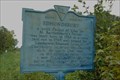 view gallery view gallery W20.4 km W20.4 km
| 15-3 Edmundsbury in South Carolina Historical Markers Marker 15-3 Edmundsbury located on US Hwy 17 at the Ashepoo River erected by Colleton County Historical Society in 1961. posted by: mikemtn location: South Carolina date approved: 08/13/2006 last visited: 04/09/2010 |
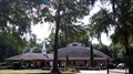
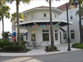 view gallery view gallerySE20.9 km |  Marble Slab Creamery - Freshfields Village - Kiawah Island, SC Marble Slab Creamery - Freshfields Village - Kiawah Island, SC
in Ice Cream Parlors This Marble Slab Creamery is located in the Freshfields Village, a shopping mall serving Kiawah Island, Seabrook Island, and Johns Island. posted by: redhead3434 location: South Carolina date approved: 07/16/2010 last visited: 07/14/2010 |
 view gallery view galleryNE22 km | 10-48 The Stono Rebellion (1739) in South Carolina Historical Markers Located on US 17 North of Hwy 162. Erected by the Sea Island Farmers Cooperative-2006. posted by: mikemtn location: South Carolina date approved: 10/14/2006 last visited: 12/28/2019 |
 view gallery view galleryNE22 km |  Stono Rebellion Stono Rebellion
in Wikipedia Entries Near this historic marker was the largest slave insurrection in British North America. posted by: ChapterhouseInc location: South Carolina date approved: 04/16/2010 last visited: 12/28/2019 |
 view gallery view galleryNE22 km |  LARGEST Slave Insurrection in British North America LARGEST Slave Insurrection in British North America
in Superlatives The site of the largest slave insurrection in British North America. posted by: ChapterhouseInc location: South Carolina date approved: 04/30/2010 last visited: 04/09/2010 |
 view gallery view galleryNE22 km |  The Stono Rebellion (1739) The Stono Rebellion (1739)
in UK Historical Markers The site of the largest slave insurrection in British North America. posted by: ChapterhouseInc location: South Carolina date approved: 04/16/2010 last visited: 01/01/2020 |
 view gallery view galleryNE23.5 km | 10-21 Grave of Colonel William A. Washington in South Carolina Historical Markers On 17S at Rantowles. posted by: carolina1 location: South Carolina date approved: 04/29/2008 last visited: 04/04/2013 |
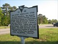
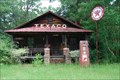 view gallery view galleryW24.1 km |  Texaco - 17S - Green Pond, SC Texaco - 17S - Green Pond, SC
in Vintage Gas Stations This old Texaco is located on 17S near Green Pond, SC. posted by: carolina1 location: South Carolina date approved: 09/14/2008 last visited: 04/09/2010 |
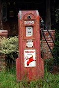 view gallery view galleryW24.1 km |  Old Texaco - Jacksonboro SC Old Texaco - Jacksonboro SC
in Vintage Gasoline Pumps Old Texaco posted by: carolina1 location: South Carolina date approved: 09/07/2008 last visited: 04/09/2010 |
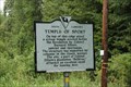 view gallery view galleryW24.5 km | 15-13 Temple of Sport in South Carolina Historical Markers Marker 15-13 Temple of Sport located on US Hwy 17 West of it's junction with SC Hwy 303, between Ashepoo and Combahee Rivers, near Green Pond. Erected by Colleton County Historical Society in 1969. posted by: mikemtn location: South Carolina date approved: 08/13/2006 last visited: 04/09/2010 |
|