 view gallery view gallery E3.9 km E3.9 km
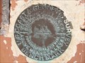
|   C-497 Benchmark - Marbury, AL C-497 Benchmark - Marbury, AL
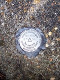
in U.S. Benchmarks The C-497 Benchmark is located at the north east corner of the CR 68 bridge over I-65. posted by:  hummerstation hummerstation location: Alabama date approved: 02/07/2016 last visited: never |
 view gallery view gallery N9.7 km N9.7 km
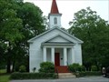
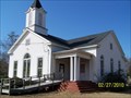
|  Verbena United Methodist Church - Verbena AL Verbena United Methodist Church - Verbena AL
in Methodist Churches The local Methodist church for my hometown of Verbena Alabama. Verbena is a small town in Chilton County Alabama. posted by: The Sims location: Alabama date approved: 06/11/2009 last visited: 10/23/2012 |
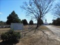
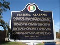 view gallery view galleryN10 km |  Verbena, Alabama Verbena, Alabama
in Alabama Historical Markers This marker telling the history of Verbena, Alabama, is located on County Road 59, not far from U.S. Highway 31. posted by: xptwo location: Alabama date approved: 10/25/2012 last visited: 09/01/2013 |
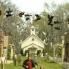 view gallery view galleryE10.9 km |  Pine Flat Presbyterian Church - Big Fish Pine Flat Presbyterian Church - Big Fish
in Movie Locations Pine Flat Presbyterian Church was the filming location for the town of Spectre in Tim Burton's 2003 film Big Fish. posted by: OHail location: Alabama date approved: 05/17/2012 last visited: never |
 view gallery view gallery SE11.9 km SE11.9 km
|  Pine Level United Methodist Church Cemetery - Prattville, AL Pine Level United Methodist Church Cemetery - Prattville, AL
in Churchyard Cemeteries Pine Level United Methodist Church Cemetery has graves dating to the 1800s. posted by: xptwo location: Alabama date approved: 02/16/2013 last visited: never |
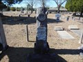 view gallery view gallerySE12.1 km |  H. B. Bazzell - Pine Level Cemetery - Prattville, AL H. B. Bazzell - Pine Level Cemetery - Prattville, AL
in Woodmen of the World Grave Markers/Monuments H. B. Bazzell was born on February 18, 1875 and died on October 8, 1915. posted by: xptwo location: Alabama date approved: 06/09/2013 last visited: never |
 view gallery view gallery S12.7 km S12.7 km
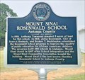
| Mount Sinai Rosenwald School - near Prattville, AL in Alabama Historical Markers First public school for African-American students in Autauga County. One of the many Rosenwald schools that was partially paid for the CEO of Sears Roebuck in 1919. posted by:  hoteltwo hoteltwo location: Alabama date approved: 11/23/2020 last visited: never |
 view gallery view galleryE13.2 km |  West Holtville Alabama Water Tank West Holtville Alabama Water Tank
in Water Towers Fairly new water tower far out in the country. posted by: HotRod205 location: Alabama date approved: 09/12/2010 last visited: 08/04/2011 |
 view gallery view gallerySE14.5 km |  Deatsville Cemetery - Deatsville, Alabama Deatsville Cemetery - Deatsville, Alabama
in Worldwide Cemeteries Deatsville Cemetery, Deatsville, Alabama posted by: hummerstation location: Alabama date approved: 03/01/2010 last visited: 08/04/2011 |
 view gallery view gallerySE14.5 km | Deatsville Cemetery - Deatsville, Alabama in Churchyard Cemeteries Deatsville Cemetery, Deatsville, Alabama posted by: hummerstation location: Alabama date approved: 04/30/2010 last visited: 08/04/2011 |
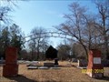 view gallery view gallerySE14.5 km |  Deatsville Cemetery Arch - Deatsville, Alabama Deatsville Cemetery Arch - Deatsville, Alabama
in Freestanding Arches Deatsville Cemetery Arch, Deatsville, Alabama posted by: hummerstation location: Alabama date approved: 03/01/2010 last visited: 08/04/2011 |
 view gallery view gallerySE14.5 km |  Sanctuary Windows - Deatsville Chapel, Deatsville, Alabama USA Sanctuary Windows - Deatsville Chapel, Deatsville, Alabama USA
in Stained Glass Windows Sanctuary Windows - Deatsville Chapel, Deatsville, Alabama USA posted by: hummerstation location: Alabama date approved: 02/28/2010 last visited: 08/04/2011 |
 view gallery view gallerySE14.5 km | Deatsville Chapel - Deatsville, Alabama in Methodist Churches Deatsville Chapel, Deatsville, Alabama posted by: hummerstation location: Alabama date approved: 03/01/2010 last visited: 08/04/2011 |
 view gallery view galleryE14.8 km | Opelika Depot CM0652 - Opelika, AL in U.S. Benchmarks This benchmark is embedded in the wall on the track side of the old Opelika Depot, which has been restored and is used by The Arts Association of East Alabama. posted by: xptwo location: Alabama date approved: 07/24/2013 last visited: never |
 view gallery view galleryN15.4 km |  Whataburger I-65 Exit 205 Clanton Alabama Whataburger I-65 Exit 205 Clanton Alabama
in Burger Shops - Regional Chains Whataburger located at I-65, exit 205, in Clanton, Alabama. posted by: xptwo location: Alabama date approved: 10/20/2011 last visited: never |
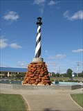 view gallery view galleryN15.4 km |  Peach Park Lighthouse - Clanton, AL Peach Park Lighthouse - Clanton, AL
in Roadside Attractions This lighthouse is part of a fountain at Peach Park in Clanton, Alabama. posted by: xptwo location: Alabama date approved: 10/13/2012 last visited: never |
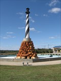 view gallery view galleryN15.4 km |  Peach Park Lighthouse - Clanton, AL Peach Park Lighthouse - Clanton, AL
in Landlocked Lighthouses This lighthouse is part of a fountain at Peach Park in Clanton, Alabama. posted by: xptwo location: Alabama date approved: 08/03/2012 last visited: 10/08/2012 |
 N15.6 km |  Clanton, Alabama Clanton, Alabama
in McDonald's Restaurants Just a quick hop off of I-65 in Clanton, accross from Peach Park. Little J enjoys a yummy breakfast here from time to time! posted by: bamageek location: Alabama date approved: 08/15/2005 last visited: 10/08/2012 |
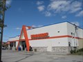
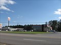 view gallery view galleryN15.8 km |  Burger King - I-65 and US 31 - Clanton, AL Burger King - I-65 and US 31 - Clanton, AL
in Burger King Restaurants Located at exit 205 of I-65 in Clanton, Alabama, this Burger King was recently renovated and has a new look. posted by: xptwo location: Alabama date approved: 10/09/2012 last visited: never |
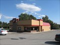 view gallery view galleryN15.9 km | Jack's I-65 - Clanton, Alabama in Burger Shops - Regional Chains This Jack's, one of two in Clanton, is located near exit 205 of I-65 in Clanton, Alabama. It is west of the interstate on U.S. Highway 31. posted by: xptwo location: Alabama date approved: 10/25/2012 last visited: 11/13/2012 |
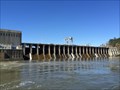 view gallery view gallery NE17.7 km NE17.7 km
|  Mitchell Dam - Verbena, Alabama Mitchell Dam - Verbena, Alabama
in Water Dams Located on the Coosa River near a location called Duncan's Riffle, the dam straddles the Chilton and Coosa County line. It houses the 2nd oldest of Alabama Power Company's hydroelectric plants. posted by: hoteltwo location: Alabama date approved: 03/25/2014 last visited: never |
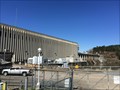 view gallery view galleryNE17.7 km |  Mitchell Hydroelectric Generating Plant - Verbena, AL, US Mitchell Hydroelectric Generating Plant - Verbena, AL, US
in Hydroelectric Power Stations Located on the Coosa River, near a location called Duncan's Riffle, the hydroelectric plant, straddles the Chilton and Coosa County line. It houses, as part of the Mitchell Dam, the 2nd oldest of Alabama Power Company's hydroelectric plants. posted by: hoteltwo location: Alabama date approved: 03/24/2014 last visited: never |
 view gallery view gallery NW19.2 km NW19.2 km
| Clanton South Municipal Tank - Clanton, AL in Water Towers This water tower is one of several used by surveyors in Clanton, Alabama. posted by: xptwo location: Alabama date approved: 12/20/2012 last visited: never |
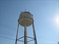 view gallery view galleryNW19.2 km | Clanton South Municipal Tank (CN2961) - Clanton, AL in U.S. Benchmarks This water tower is one of several used by surveyors in Clanton, Alabama. posted by: xptwo location: Alabama date approved: 11/23/2012 last visited: never |
 view gallery view gallerySE19.2 km | CN3270 - Prattville, AL in U.S. Benchmarks This mark is located on U.S. Highway 31 north of Prattville, Alabama. It is located on the east side of the road. posted by: xptwo location: Alabama date approved: 11/23/2012 last visited: never |
|