 view gallery view gallery E0.8 km E0.8 km
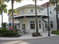
|   Marble Slab Creamery - Freshfields Village - Kiawah Island, SC Marble Slab Creamery - Freshfields Village - Kiawah Island, SC
in Ice Cream Parlors This Marble Slab Creamery is located in the Freshfields Village, a shopping mall serving Kiawah Island, Seabrook Island, and Johns Island. posted by:  redhead3434 redhead3434 location: South Carolina date approved: 07/16/2010 last visited: 07/14/2010 |
 view gallery view gallery NW3.4 km NW3.4 km
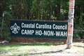
|  Camp Ho-Non-Wah, Wadmalaw Island, SC Camp Ho-Non-Wah, Wadmalaw Island, SC
in Boy Scout Camps Camp Ho-Non-Wah is located on Wadmalaw Island, SC. posted by:  carolina1 carolina1 location: South Carolina date approved: 09/10/2008 last visited: 06/25/2010 |
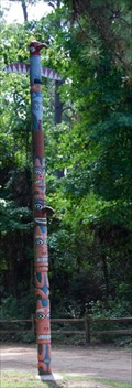 view gallery view galleryNW3.4 km |  Totem Pole - Wadmalaw Island, SC Totem Pole - Wadmalaw Island, SC
in Outside Wooden Display Carvings Totem Pole located at the entrance of Camp Ho-Non-Wah Boy Scout
Camp. posted by: carolina1 location: South Carolina date approved: 09/14/2008 last visited: 06/25/2010 |
 view gallery view gallery N8.4 km N8.4 km
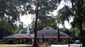
|  St James Bethel AME Church - Wadmalaw Island, SC St James Bethel AME Church - Wadmalaw Island, SC
in Geodesic Domes 5305 Maybank Hwy, Wadmalaw Island, SC - (843) 559-2442? posted by: carolina1 location: South Carolina date approved: 09/11/2008 last visited: 06/25/2010 |
 NW8.5 km |  Irvin-House Vineyard Irvin-House Vineyard
in Wineries Irvin-House Vineyard is located on Wadmalaw Island, SC and is Charleston's only domestic winery. posted by: JI Sandlappers location: South Carolina date approved: 01/02/2006 last visited: 10/21/2010 |
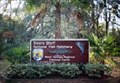 view gallery view galleryNW9.8 km |  Bears Bluff National Fish Hatchery - Wadmalaw Island - SC Bears Bluff National Fish Hatchery - Wadmalaw Island - SC
in Fish Hatcheries Bears Bluff National Fish Hatchery is a unit of the Warm Springs Fish Technology Center, a component of the Warm Springs Regional Fisheries Center, Warm Springs, Georgia posted by: carolina1 location: South Carolina date approved: 09/03/2008 last visited: 10/21/2010 |
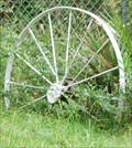 view gallery view gallery W12.4 km W12.4 km
|  Wagon Wheels - Edisto, SC Wagon Wheels - Edisto, SC
in Wagon Wheels Wagon Wheels near Edisto Beach, SC. posted by: carolina1 location: South Carolina date approved: 01/22/2009 last visited: 01/22/2009 |
 view gallery view gallery NE13.5 km NE13.5 km
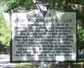
|  10-81 The Progressive Club - Charleston, SC 10-81 The Progressive Club - Charleston, SC
in South Carolina Historical Markers 10-81 The Progressive Club is located on River Road. posted by: hummerstation location: South Carolina date approved: 06/06/2016 last visited: never |
 view gallery view galleryNE13.5 km |  Progressive Club, The - Charleston, SC Progressive Club, The - Charleston, SC
in U.S. National Register of Historic Places The Progressive Club was founded in 1948 by civil rights activist Esau Jenkins (1910-1972). posted by: hummerstation location: South Carolina date approved: 07/12/2016 last visited: never |
 view gallery view galleryNE13.5 km |  The Progressive Club - Charleston, SC The Progressive Club - Charleston, SC
in Wikipedia Entries The Progressive Club was founded in 1948 by civil rights activist Esau Jenkins (1910-1972). posted by: hummerstation location: South Carolina date approved: 07/12/2016 last visited: never |
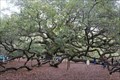 view gallery view galleryNE14.3 km |  "Community celebrates preservation of land around Angel Oak" - Johns Island, South Carolina "Community celebrates preservation of land around Angel Oak" - Johns Island, South Carolina
in News Article Locations Angel Oak is estimated to be 1,400 years old - perhaps the oldest living thing east of the Mississippi River. To protect the tree, Lowcountry Open Land Trust announced they now officially own the 17 acres adjacent to Angel Oak Park. posted by: Trail Blaisers location: South Carolina date approved: 10/11/2016 last visited: never |
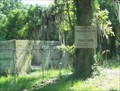
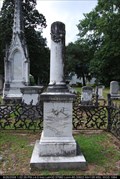 view gallery view galleryW14.5 km |  Seabrook - Presbyterian Church Cemetery - Edisto Island, SC Seabrook - Presbyterian Church Cemetery - Edisto Island, SC
in Broken Column Headstones Cornelia Adelaide Seabrook
Presbyterian Church on Edisto Island posted by: carolina1 location: South Carolina date approved: 08/27/2008 last visited: 08/27/2008 |
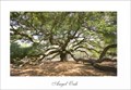 view gallery view galleryNE14.5 km |  Angel Oak, Johns Island, South Carolina Angel Oak, Johns Island, South Carolina
in Picture Perfect Postcards Angel Oak, Johns Island, South Carolina. posted by: carolina1 location: South Carolina date approved: 09/08/2008 last visited: 03/26/2016 |
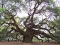 view gallery view galleryNE14.5 km |  Angel Oak Angel Oak
in Exceptional Trees This is The Angel Oak, the oldest living thing East of the Mississippi River posted by: Mvillian location: South Carolina date approved: 05/01/2006 last visited: 03/26/2016 |
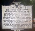 view gallery view galleryN16.1 km | 10-36 St Paul's Stono/St Paul's Churchyard - Meggett, SC in South Carolina Historical Markers The 10-36 St Paul's Stono/St Paul's Churchyard historical marker is located on State Hwy 162. posted by: hummerstation location: South Carolina date approved: 06/07/2016 last visited: never |
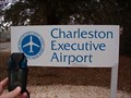 view gallery view galleryNE17.1 km |  Charleston Executive Airport Charleston Executive Airport
in Airports Located on Johns Island, SC. posted by: JI Sandlappers location: South Carolina date approved: 01/03/2006 last visited: 11/27/2004 |
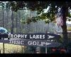 view gallery view galleryNE17.9 km |  Trophy Lakes Trophy Lakes
in Disc Golf Courses Trophy Lakes
Charleston (Johns Island), South Carolina 29455
posted by: carolina1 location: South Carolina date approved: 08/26/2007 last visited: 08/26/2007 |
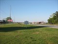
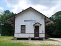 view gallery view galleryNW19.5 km |  Ravenel Depot/Ravenel, SC Ravenel Depot/Ravenel, SC
in Train Stations/Depots Located in Ravenel, SC. posted by: carolina1 location: South Carolina date approved: 09/15/2008 last visited: 01/10/2024 |
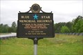 view gallery view galleryN19.6 km |  US Highway 17S - South Carolina US Highway 17S - South Carolina
in Blue Star Memorial Highway Markers Blue Star on Highway 17S near Ravenel, SC. posted by: carolina1 location: South Carolina date approved: 04/23/2008 last visited: 12/30/2019 |
 view gallery view galleryN20.1 km |  LARGEST Slave Insurrection in British North America LARGEST Slave Insurrection in British North America
in Superlatives The site of the largest slave insurrection in British North America. posted by: ChapterhouseInc location: South Carolina date approved: 04/30/2010 last visited: 04/09/2010 |
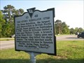 view gallery view galleryN20.1 km |  The Stono Rebellion (1739) The Stono Rebellion (1739)
in UK Historical Markers The site of the largest slave insurrection in British North America. posted by: ChapterhouseInc location: South Carolina date approved: 04/16/2010 last visited: 01/01/2020 |
 view gallery view galleryN20.1 km | Stono Rebellion in Wikipedia Entries Near this historic marker was the largest slave insurrection in British North America. posted by: ChapterhouseInc location: South Carolina date approved: 04/16/2010 last visited: 12/28/2019 |
 view gallery view galleryN20.1 km | 10-48 The Stono Rebellion (1739) in South Carolina Historical Markers Located on US 17 North of Hwy 162. Erected by the Sea Island Farmers Cooperative-2006. posted by:  mikemtn mikemtn location: South Carolina date approved: 10/14/2006 last visited: 12/28/2019 |
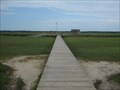 view gallery view galleryNE20.6 km |  James Island County Park Pier - Charleston, SC James Island County Park Pier - Charleston, SC
in Piers A smaller pier providing water and fishing access. posted by: ChapterhouseInc location: South Carolina date approved: 09/17/2010 last visited: 06/06/2010 |
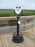 view gallery view galleryNE20.6 km |  James Island County Park Binoculars - SC James Island County Park Binoculars - SC
in Coin-Op Binoculars Located off the fishing pier inside this state park. posted by: ChapterhouseInc location: South Carolina date approved: 06/21/2010 last visited: 06/06/2010 |
|