 view gallery view gallery NW0 km NW0 km
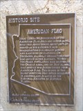
|   American Flag American Flag
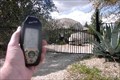
in Arizona Historical Markers Isaac Lorraine, discoverer of the American Flag gold and silver mine, built this adobe house about 1877. posted by:  leadhiker leadhiker location: Arizona date approved: 05/28/2010 last visited: never |
 view gallery view gallery SW1.9 km SW1.9 km
|  Arizona National Scenic Trail (High Jinks Ranch) - Oracle, Arizona Arizona National Scenic Trail (High Jinks Ranch) - Oracle, Arizona
in Long Distance Hiking Trails Located at the south of Oracle on the Arizona National Scenic Trail posted by:  flyingmoose flyingmoose location: Arizona date approved: 12/06/2021 last visited: never |
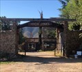
 view gallery view gallerySW1.9 km |  La Casa del High Jinks - Oracle, Arizona La Casa del High Jinks - Oracle, Arizona
in William F. "Buffalo Bill" Cody Located south of Oracle at the end of South High Jinks Road. posted by: flyingmoose location: Arizona date approved: 11/22/2021 last visited: never |
 view gallery view gallerySW1.9 km |  La Casa del High Jinks - Oracle, Arizona La Casa del High Jinks - Oracle, Arizona
in U.S. National Register of Historic Places Located south of Oracle at the end of South High Jinks Road. posted by: flyingmoose location: Arizona date approved: 11/27/2021 last visited: never |
 view gallery view gallerySW1.9 km |  La Casa del High Jinks - Oracle, Arizona La Casa del High Jinks - Oracle, Arizona
in Hostels Located south of Oracle at the end of South High Jinks Road where it intersects with the Arizona Trail. posted by: flyingmoose location: Arizona date approved: 12/01/2021 last visited: never |
 NW5.3 km |  Acadia Ranch Museum Acadia Ranch Museum
in History Museums Contains many historical items about Oracle, Arizona posted by: Cog&Gil location: Arizona date approved: 06/25/2006 last visited: never |
 view gallery view galleryNW5.3 km | Acadia Ranch - Oracle AZ in U.S. National Register of Historic Places Today the Acadia Ranch serves as a museum devoted to the Oracle area's rich history, as well as the headquarters of the Oracle Historical Society. posted by: leadhiker location: Arizona date approved: 05/25/2010 last visited: never |
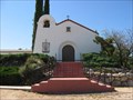
 view gallery view galleryNW5.5 km | All Saint's Church - Oracle, AZ in U.S. National Register of Historic Places The All Saints Church was built in 1901. This building was placed on the National Register of Historical Places on May 3, 1984. posted by: leadhiker location: Arizona date approved: 05/25/2010 last visited: 08/28/2022 |
 view gallery view galleryNW6.1 km |  St. Helen's Mission Church - Oracle, AZ St. Helen's Mission Church - Oracle, AZ
in Roman Catholic Churches A historic Catholic Mission Church located near the intersection of W American Ave & Maplewood Dr. posted by: HiFiLZ location: Arizona date approved: 05/27/2008 last visited: 03/19/2011 |
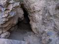 view gallery view gallery S6.3 km S6.3 km
| ") Pepper Sauce Cave Entrance (Natural), Oracle, AZ Pepper Sauce Cave Entrance (Natural), Oracle, AZ
in Cave Entrances (Natural) This natural cave entrance is for Pepper Sauce Cave located on Mt Lemmon Road in the Coronado National Forest in Oracle, AZ. posted by: Poehunters location: Arizona date approved: 08/16/2013 last visited: 08/16/2013 |
 view gallery view galleryNW6.8 km |  Dome Home, Oracle, AZ Dome Home, Oracle, AZ
in Geodesic Domes This is a geodesic dome house located in Oracle, AZ. posted by: TucsonThompsen location: Arizona date approved: 06/16/2010 last visited: never |
 view gallery view galleryNW9.7 km |  Ghost Bike - Oracle, AZ Ghost Bike - Oracle, AZ
in Ghost Bikes Ghost bike located near Oracle, AZ on the south side of Highway 77 at mile marker 99.6 posted by: T2D location: Arizona date approved: 08/29/2022 last visited: never |
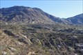 view gallery view gallerySW11.1 km |  Charouleau Gap - Arizona Charouleau Gap - Arizona
in Named Mountain Gaps A 4WD road takes you to Charouleau Gap at the northern part of the Santa Catalina Mountains of Southern Arizona. posted by: Team2002 location: Arizona date approved: 01/25/2012 last visited: 09/23/2021 |
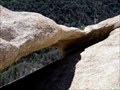 view gallery view galleryS13.5 km | Reef of Rock Natural Arch in Natural Arches A small natural arch located north of Mt. Lemmon, AZ posted by: TucsonThompsen location: Arizona date approved: 09/14/2011 last visited: 12/15/2014 |
 view gallery view galleryS15.8 km |  Mount Lemmon Ski Lift - Mount Lemmon, AZ Mount Lemmon Ski Lift - Mount Lemmon, AZ
in Aerial Lifts Ski Lift at Mount Lemmon, AZ posted by: philbeer location: Arizona date approved: 07/15/2013 last visited: 09/05/2022 |
 view gallery view galleryS15.8 km |  Mount Lemmon Ski Lift - Mount Lemmon, AZ Mount Lemmon Ski Lift - Mount Lemmon, AZ
in Elevation Signs Lower Ski Lift at Mount Lemmon, AZ elevation sign 8,225ft. posted by: philbeer location: Arizona date approved: 07/17/2013 last visited: 11/28/2014 |
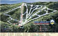
 view gallery view galleryS15.8 km |  Ski Valley, Mt Lemmon, AZ Ski Valley, Mt Lemmon, AZ
in Ski Lodges Ski Valley can be found on Mt Lemmon in Mt Lemmon, AZ posted by: Poehunters location: Arizona date approved: 08/16/2013 last visited: 08/08/2021 |
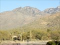 view gallery view gallerySW16.6 km |  Santa Catalina Mountains - Tucsonopoly - Tucson, AZ Santa Catalina Mountains - Tucsonopoly - Tucson, AZ
in Monopoly in the Real World The Catalina Mountains are located on the north and northeast side of Tucson posted by: Max and 99 location: Oklahoma date approved: 01/21/2020 last visited: never |
 view gallery view gallerySW16.6 km |  Mount Lemmon, highest point in Pima County, Arizona Mount Lemmon, highest point in Pima County, Arizona
in Geographic High Points Mount Lemmon, at over 9,000', is the highest point in Pima County. posted by: tugies location: Arizona date approved: 12/18/2013 last visited: 09/09/2019 |
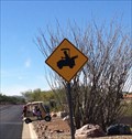 view gallery view gallery W17.1 km W17.1 km
|  Golf Cart Crossing-Saddlebrooke-Arizona Golf Cart Crossing-Saddlebrooke-Arizona
in Uncommon Crossing Signs When driving on E Flower Ridge Dr. keep a look out for the wild golf carts. posted by: grandmabetsy location: Arizona date approved: 12/11/2013 last visited: 01/09/2024 |
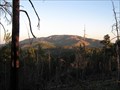
 view gallery view galleryS17.4 km |  Plane Crash on Mt. Bigelow Plane Crash on Mt. Bigelow
in Plane Crash Sites Late in the afternoon of 8 July 1957, two F-86 Saberjet fighter aircraft from Davis-Monthan Air Force Base met in a midair collision in
the sky over Mount Bigelow. posted by: Poehunters location: Arizona date approved: 06/26/2013 last visited: 06/11/2021 |
 view gallery view galleryS17.4 km |  Lemmon Rock Lookout House Lemmon Rock Lookout House
in Civilian Conservation Corps Lemmon Rock Lookout House was built in the 1930s by the Civilian Conservation Corp. posted by: rambles location: Arizona date approved: 08/25/2008 last visited: 07/05/2013 |
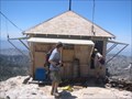 view gallery view galleryS17.4 km | Lemmon Rock Lookout House in U.S. National Register of Historic Places This lookout was built on Mt Lemmon just south of the summit on Lemmon Rock. It has been staffed for 70 years
posted by: rambles location: Arizona date approved: 07/08/2008 last visited: 07/13/2013 |
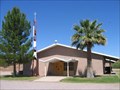 view gallery view gallery NE17.7 km NE17.7 km
| Blessed Sacrament Church - Mammoth, AZ in Roman Catholic Churches A Catholic Church located along W Church Drive. posted by: HiFiLZ location: Arizona date approved: 05/27/2008 last visited: 05/17/2008 |
 view gallery view gallerySW18.2 km |  AZ Township 11S 14E corner of Sections 11, 12, 13 & 14 AZ Township 11S 14E corner of Sections 11, 12, 13 & 14
in Public Land Survey Marks AZ Township 1911 marker 11S 14E corner of Sections 11, 12, 13 & 14 posted by: ccprob location: Arizona date approved: 01/04/2013 last visited: never |
|