 view gallery view gallery NE10 km NE10 km
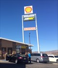
|   Subway - Carrizo Gorge Rd. - Jacumba Hot Springs, CA Subway - Carrizo Gorge Rd. - Jacumba Hot Springs, CA
in Subway Restaurants A Subway near Mexico, along Interstate 8. posted by:  bluesnote bluesnote location: California date approved: 02/01/2016 last visited: 02/01/2016 |
 view gallery view gallery NW13.5 km NW13.5 km
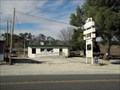
|  Boulevard CA 91905 Boulevard CA 91905
in U.S. Post Offices This small post office is on Old Hwy 80 (Hwy 94) in Boulevard, California. posted by: PeterNoG location: California date approved: 03/16/2011 last visited: 03/02/2011 |
 view gallery view galleryNE16.3 km |  Desert Tower - Jacumba, CA Desert Tower - Jacumba, CA
in E Clampus Vitus Historical Markers This plaque is located in the mountains terrain between San Diego, and Yuma. posted by: bluesnote location: California date approved: 12/27/2013 last visited: 07/06/2018 |
 view gallery view galleryNE16.3 km |  Desert Tower - Jacumba, CA Desert Tower - Jacumba, CA
in Cairns This plaque is located in the mountains terrain between San Diego, and Yuma. posted by: bluesnote location: California date approved: 11/20/2017 last visited: 11/20/2017 |
 view gallery view galleryNE16.3 km |  Desert Tower - Jacumba, CA Desert Tower - Jacumba, CA
in California Historical Markers This historical marker is located at Desert View Tower near Jacumba, CA posted by:  Team Min Dawg Team Min Dawg location: California date approved: 06/14/2010 last visited: 07/06/2018 |
 view gallery view galleryNE16.3 km |  Desert View Tower - Jacumba, CA Desert View Tower - Jacumba, CA
in Ghosts and Hauntings The desert tower is part of the old spanish auto trail. posted by: bluesnote location: California date approved: 06/18/2017 last visited: 06/18/2017 |
 view gallery view galleryNE16.3 km |  Desert View Tower - Jacumba, CA Desert View Tower - Jacumba, CA
in Wikipedia Entries The desert tower is part of the old spanish auto trail. posted by: bluesnote location: California date approved: 12/22/2013 last visited: 02/11/2018 |
 view gallery view galleryNE16.3 km |  Desert View Tower - Jacumba, CA Desert View Tower - Jacumba, CA
in Roadside Attractions The desert tower is part of the old spanish auto trail. posted by: bluesnote location: California date approved: 12/24/2013 last visited: 07/06/2018 |
 view gallery view galleryNE16.3 km |  Desert View Tower - Jacumba, CA Desert View Tower - Jacumba, CA
in U.S. National Register of Historic Places The desert tower is part of the old spanish auto trail. posted by: bluesnote location: California date approved: 12/22/2013 last visited: 07/06/2018 |
 view gallery view galleryNE16.3 km |  Desert View Tower - Jacumba, CA Desert View Tower - Jacumba, CA
in Look-Out Towers The desert tower is part of the old spanish auto trail. posted by: bluesnote location: California date approved: 12/23/2013 last visited: 02/11/2018 |
 view gallery view galleryNE16.3 km | Desert View Tower - Jacumba, CA in Cairns The desert tower is part of the old spanish auto trail. posted by: bluesnote location: California date approved: 02/19/2022 last visited: never |
 view gallery view galleryNE16.3 km |  Desert View Tower - Jacumba, CA Desert View Tower - Jacumba, CA
in Satellite Imagery Oddities The desert tower is part of the old spanish auto trail. posted by: bluesnote location: California date approved: 06/18/2017 last visited: 07/06/2018 |
 view gallery view galleryNE16.3 km |  Desert View Tower - Jacumba, CA Desert View Tower - Jacumba, CA
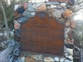
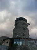
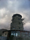
in Old Spanish Trail Auto Route This tower was built in the early 1920's to commemorate the building of the road and railroad through the area. This is a dog-friendly place! posted by: Team Min Dawg location: California date approved: 06/09/2010 last visited: 07/06/2018 |
 view gallery view galleryNW16.3 km |  John William Finn-Live Oak Springs, CA John William Finn-Live Oak Springs, CA
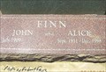
in Medal Of Honor Resting Places World War II Medal of Honor Recipient for action during the attack on Pearl Harbor, Hawaii on December 7, 1941. He is buried in Saint Carmel Cemetery, Live Oak Springs, CA. posted by: Don.Morfe location: California date approved: 10/28/2019 last visited: never |
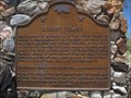
 view gallery view galleryNE16.3 km | Mountain Springs Station Site - Jacumba, CA in California Historical Markers This is one of two state markers located here. posted by: bluesnote location: California date approved: 03/13/2013 last visited: 07/06/2018 |
 view gallery view galleryNE16.3 km | Mountain Springs Station Site - Jacumba, CA in E Clampus Vitus Historical Markers This is one of two state markers located here. posted by: bluesnote location: California date approved: 12/27/2013 last visited: 05/20/2022 |
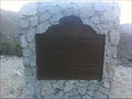 view gallery view galleryNE16.3 km | Mountain Springs Station Site - Jacumba, CA in Cairns This is one of two state markers located here. posted by: bluesnote location: California date approved: 11/20/2017 last visited: 11/20/2017 |
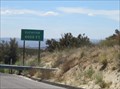 view gallery view galleryNW16.9 km |  I-8 Eastbound - 4,000 Ft I-8 Eastbound - 4,000 Ft
in Elevation Signs A sign on I-8 eastbound by Pine Valley, CA. posted by: saopaulo1 location: California date approved: 09/01/2011 last visited: 12/16/2017 |
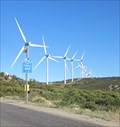 view gallery view galleryNW18 km |  I-8 Windmill Farms - Pine Valley, CA I-8 Windmill Farms - Pine Valley, CA
in Windmills A wind farm by I-8 in Pine Valley, CA. posted by: saopaulo1 location: California date approved: 08/25/2011 last visited: 02/11/2018 |
 view gallery view galleryNE18.7 km | I-8 Westbound - 2,000 Ft in Elevation Signs A sign on westbound I-8 in San Diego County. posted by: saopaulo1 location: California date approved: 09/01/2011 last visited: 12/16/2017 |
 view gallery view galleryNE19 km |  Devil's Canyon Devil's Canyon
in Geological Devilish Locations Devil's Canyon located in Southern California. posted by: frivlas location: California date approved: 02/22/2007 last visited: 04/14/2010 |
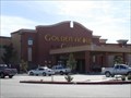 view gallery view galleryNW19.6 km |  Golden Acorn Casino Golden Acorn Casino
in Casinos Golden Acorn Casino, Old Highway 80, Campo. posted by: Pioneer 'n' Tiff location: California date approved: 01/18/2007 last visited: 12/19/2015 |
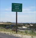 view gallery view galleryNW20.4 km |  Campo Indian Reservation - Campo, CA Campo Indian Reservation - Campo, CA
in Nations Within Nations The sign for the Campo Indian Reservation is located along I-8 in Campo, CA posted by: saopaulo1 location: California date approved: 09/03/2011 last visited: 03/02/2012 |
 view gallery view galleryNW22.2 km | La Posta Casino, Boulevard CA in Casinos La Posta Casino on the La Posta Indian Reservation in San Diego County. posted by: Johnny_Quest location: California date approved: 12/29/2009 last visited: never |
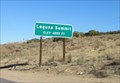 view gallery view galleryNW22.5 km | Laguna Summit - 4055 Ft in Elevation Signs A sign at the Laguna Summit in the Laguna Mountains of San Diego county. posted by: saopaulo1 location: California date approved: 09/01/2011 last visited: never |
|