 view gallery view gallery S5.6 km S5.6 km
|   Bartram's Trail - Tuskegee National Forest, Alabama Bartram's Trail - Tuskegee National Forest, Alabama
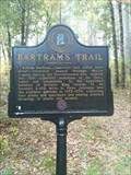
in Bartram Trail Historical Markers Bartram's Trail Marker in the Tuskegee National Forest, Alabama posted by:  xptwo xptwo location: Alabama date approved: 10/18/2011 last visited: 01/12/2022 |
 view gallery view galleryS5.6 km |  Bartram's Trail - Tuskegee National Forest, Alabama Bartram's Trail - Tuskegee National Forest, Alabama
in Alabama Historical Markers Bartram's Trail Marker in the Tuskegee National Forest, Alabama posted by: xptwo location: Alabama date approved: 10/18/2011 last visited: 05/05/2022 |
 view gallery view galleryS5.6 km |  Bartram's Trail - Tuskegee National Forest, Alabama Bartram's Trail - Tuskegee National Forest, Alabama
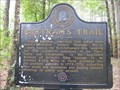
in UK Historical Markers Bartram's Trail Marker in the Tuskegee National Forest, Alabama posted by: xptwo location: Alabama date approved: 07/07/2012 last visited: 09/15/2012 |
 view gallery view galleryS5.6 km |  Bartram's Trail - Tuskegee National Forest, Alabama Bartram's Trail - Tuskegee National Forest, Alabama
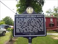
in Spirit of '76 This Bartram's Trail Marker in the Tuskegee National Forest, Alabama, was erected by the Alabama Bicentennial Commission. posted by: xptwo location: Alabama date approved: 09/16/2012 last visited: 09/15/2012 |
 view gallery view gallery W6.9 km W6.9 km
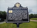
| Shiloh-Rosenwald School - Notasulga, Alabama in Alabama Historical Markers Marker is at the intersection of Tuskegee Street (AL-81) and Shiloh Road south of Notasulga describes one of the early (and few remaining) African-American school houses funded by Sears founder Julius Rosenwald. posted by:  hoteltwo hoteltwo location: Alabama date approved: 06/21/2016 last visited: 07/11/2022 |
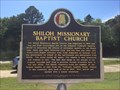 view gallery view galleryW6.9 km | Shiloh Missionary Baptist Church - Notasulga, AL in Alabama Historical Markers Located at the intersection of Tuskegee Street (AL-81) and Shiloh Road, south of Notasulga, describes the church and largest site of the infamous Tuskegee syphilis study. posted by: hoteltwo location: Alabama date approved: 06/25/2016 last visited: 07/11/2022 |
 view gallery view gallery NW6.9 km NW6.9 km
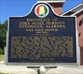
| Birthplace of Zora Neale Hurston - Notasulga, AL in Alabama Historical Markers Located on Auburn Road, 0.3 miles east of Tallapoosa Street, describes the noted authors' local beginnings and a history of her writings. posted by: hoteltwo location: Alabama date approved: 06/25/2016 last visited: 07/11/2022 |
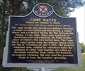 view gallery view galleryW7.1 km | Camp Watts Named for Thomas H. Watts in Alabama Historical Markers Located along Union Camp Rd., south of Notasulga, this marker notes the former area of a Civil War camp and cemetery. Camp Watts is currently private property and is used for cattle. posted by: hoteltwo location: Alabama date approved: 06/21/2016 last visited: 07/11/2022 |
 view gallery view gallery N8 km N8 km
| First Rosenwald School - Loachapoka, AL in Alabama Historical Markers This two-sided marker in Loachapoka, Alabama, tells the history of the first of 5,300 Rosenwald schools for black children to be built. posted by: xptwo location: Alabama date approved: 08/01/2013 last visited: 01/12/2022 |
 view gallery view galleryN8.2 km |  Auburn University Chapel - Auburn, AL Auburn University Chapel - Auburn, AL
in Wikipedia Entries The Auburn University Chapel has had many uses since it was built in 1850 as a Presbyterian Church, including time as a YMCA center and theater. posted by: xptwo location: Alabama date approved: 03/24/2013 last visited: never |
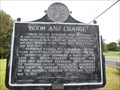 view gallery view galleryN8.2 km | Boom and Change - Loachapoka, AL in Alabama Historical Markers Placed by the Historic Chattahoochee Commission in 1978, this marker tells of the rise and fall of the town of Loachapoka, Alabama. posted by: xptwo location: Alabama date approved: 08/23/2013 last visited: 03/08/2006 |
 view gallery view galleryN8.2 km | Lee County Historical Society - Loachapoka, AL in Alabama Historical Markers This marker gives the history of those who founded the Lee County Historical Society. It is located in Pioneer Park in Loachapoka, Alabama. posted by: xptwo location: Alabama date approved: 08/01/2013 last visited: 01/12/2022 |
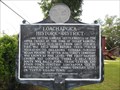 view gallery view galleryN8.2 km | Loachapoka Historic District - Loachapoka, AL in Alabama Historical Markers This historic marker relates the early history of the town of Loachapoka, Alabama. It is located in Pioneer Park. posted by: xptwo location: Alabama date approved: 07/29/2013 last visited: 03/08/2006 |
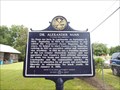 view gallery view galleryN8.2 km | Dr. Alexander Nunn - Loachapoka, AL in Alabama Historical Markers This particular marker in Pioneer Park in Loachapoka, Alabama, honors the memory of Dr. Alexander Nunn, the first historian for Lee County. posted by: xptwo location: Alabama date approved: 08/24/2013 last visited: 01/12/2022 |
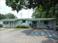 view gallery view galleryN8.2 km |  Loachapoka, Alabama 36865 Loachapoka, Alabama 36865
in U.S. Post Offices This post office is located at 6520 Stage Road in Loachapoka, Alabama. Stage Road is also known as Alabama Highway 14. posted by: xptwo location: Alabama date approved: 07/29/2013 last visited: never |
 view gallery view gallery SE9 km SE9 km
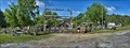
|  Hillbilly Mall - Tuskegee AL Hillbilly Mall - Tuskegee AL
in Roadside Attractions Located on US 80 just before its intersection with US 29 in Tuskegee posted by: nomadwillie location: Alabama date approved: 01/01/2017 last visited: never |
 view gallery view gallerySE9 km |  Hillbilly Mall - Tuskegee AL Hillbilly Mall - Tuskegee AL
in Antique Shops Unusual collection of items along US 80 in Tuskegee AL posted by: nomadwillie location: Alabama date approved: 01/01/2017 last visited: never |
 view gallery view gallerySE9 km |  Hillbilly Mall - Tuskegee AL Hillbilly Mall - Tuskegee AL
in Themed Homemade Mailboxes Located on US 80 just outside of Tuskegee AL posted by: nomadwillie location: Alabama date approved: 01/09/2017 last visited: never |
 view gallery view gallerySE9 km |  Hillbilly Mall Truck - Tuskegee AL Hillbilly Mall Truck - Tuskegee AL
in Art Vehicles Abandoned truck located just outside of the entrance to the mall used as an eye catcher to lure folks in. posted by: nomadwillie location: Alabama date approved: 05/07/2017 last visited: never |
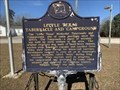 view gallery view galleryS10.3 km | Little Texas Tabernacle and Campground - Little Texas, AL in Alabama Historical Markers Located off County Route 69 near Little Texas Road (County Route 71), Little Texas posted by: Markerman62 location: Alabama date approved: 06/02/2022 last visited: never |
 view gallery view gallery SW10.8 km SW10.8 km
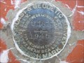
|  Moton Field Control Tower CM1200 - Tuskegee, AL Moton Field Control Tower CM1200 - Tuskegee, AL
in U.S. Benchmarks This benchmark is located on the Control Tower at the Moton Field National Park Service Historic Site in Tuskegee, Alabama. posted by: xptwo location: Alabama date approved: 10/05/2012 last visited: 12/22/2023 |
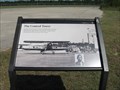 view gallery view gallerySW10.8 km |  The Control Tower - Tuskegee, AL The Control Tower - Tuskegee, AL
in Signs of History Moton Field was the home of the initial flight training for the men who became the Tuskegee Airmen. This information sign tells the visitor about the importance of the Control Tower in the training process. posted by: xptwo location: Alabama date approved: 07/10/2013 last visited: 07/28/2017 |
 view gallery view gallerySW10.8 km | A Typical Day - Tuskegee, AL in Signs of History This information sign tells visitors about a typical day for the trainees who would become the WWII Tuskegee Airmen. It is located on the ramp between Hangar No. 1 and Hangar No. 2 at the Tuskegee Airmen National Historic Site in Tuskegee, Alabama. posted by: xptwo location: Alabama date approved: 07/22/2013 last visited: 07/28/2017 |
 view gallery view gallerySW10.8 km |  P51 Mustang (replica) - Tuskegee Airmen National Historic Site - Tuskegee AL P51 Mustang (replica) - Tuskegee Airmen National Historic Site - Tuskegee AL
in Static Aircraft Displays P-51 Mustang (replica) is on permanent display at the Tuskegee Airmen National Historic Site. posted by: nomadwillie location: Alabama date approved: 01/02/2017 last visited: 07/28/2017 |
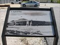
 view gallery view gallerySW10.8 km |  Tuskegee Airmen National Historic Site - Tuskegee AL Tuskegee Airmen National Historic Site - Tuskegee AL
in History Museums Tuskegee Airmen National Historic Site, at Moton Field in Tuskegee, Alabama, commemorates the contributions of African American airmen in World War II. posted by: nomadwillie location: Alabama date approved: 01/02/2017 last visited: 07/28/2017 |
|