  SE0.6 km SE0.6 km
|   Kitchen Express Kitchen Express
in Classic BBQ and Sandwich Joints A permanent Roach Coach in Eunice posted by:  Team Simber Team Simber location: New Mexico date approved: 04/04/2007 last visited: never |
 view gallery view gallery NW22.5 km NW22.5 km
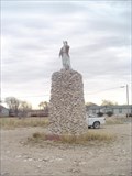
|  The Monument at Monument The Monument at Monument
in New Mexico Historical Markers "Geronimo" stands atop the monument at Monument. posted by: BewareOfPenguin location: New Mexico date approved: 01/06/2008 last visited: 12/18/2015 |
 view gallery view gallery N27 km N27 km
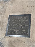
|  Commemorating 50 Years — Hobbs, NM Commemorating 50 Years — Hobbs, NM
in Time Capsules Commemorating oil conservation posted by: OcrazyS location: New Mexico date approved: 08/21/2019 last visited: never |
 view gallery view galleryN28.6 km | Hobbs, NM in New Mexico Historical Markers Named for the family of James Hobbs which homesteaded here in 1907, Hobbs became first a trading village for ranchers and then a major oil town after the discovery of oil by the Midwest Oil Company in 1928. posted by: BewareOfPenguin location: New Mexico date approved: 01/04/2008 last visited: 12/18/2015 |
 view gallery view gallery S32 km S32 km
|  The Trail Ahead... - Jal, NM The Trail Ahead... - Jal, NM
in Silhouette Public Art Sculptures This large silhouette sculpture is north of Jal, New Mexico. posted by: The Snowdog location: New Mexico date approved: 08/13/2024 last visited: never |
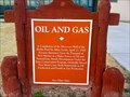 view gallery view galleryN32.5 km | Oil and Gas in New Mexico Historical Markers An Official Historical Scenic Marker honoring completion of the Discovery Well of the Hobbs Pool. posted by: Aarky location: New Mexico date approved: 12/24/2010 last visited: 12/18/2015 |
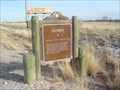
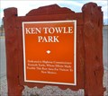 view gallery view galleryN32.5 km | Ken Towle Park in New Mexico Historical Markers A roadside marker honoring highway commissioner Kenneth Towle. posted by: Aarky location: New Mexico date approved: 12/24/2010 last visited: 02/02/2020 |
 view gallery view gallery E34.1 km E34.1 km
|  Andrews County Andrews County
in Texas Historical Markers From Andrews, take FM 87 West about 13 miles to roadside park. posted by:  GeoGrands GeoGrands location: Texas date approved: 02/04/2007 last visited: 09/29/2007 |
 view gallery view galleryS34.6 km |  Air Navigation Beacon - Jal Airport - Jal, NM Air Navigation Beacon - Jal Airport - Jal, NM
in Ground Based Air Navigation Support Structures This air navigation beacon is at Jal Airport - northeast of Jal, New Mexico. posted by: The Snowdog location: New Mexico date approved: 08/13/2024 last visited: never |
 view gallery view galleryS34.9 km |  Jal Airport - Jal, NM Jal Airport - Jal, NM
in Airports This small airport serves Lea County - in Jal, New Mexico. posted by: The Snowdog location: New Mexico date approved: 08/12/2024 last visited: never |
 view gallery view galleryS35.4 km |  3030 Ft - Jal, NM 3030 Ft - Jal, NM
in Elevation Signs This "City Limits" sign on the east edge of town also gives the elevation - in Jal, New Mexico. posted by: The Snowdog location: New Mexico date approved: 08/12/2024 last visited: never |
 view gallery view galleryS35.7 km |  Allsups - E. Kansas Avenue - Jal, NM Allsups - E. Kansas Avenue - Jal, NM
in Truck Stops This Alsups has everything a trucker needs - in Jal, New Mexico. posted by: The Snowdog location: New Mexico date approved: 08/12/2024 last visited: never |
 view gallery view galleryS36.4 km |  New Mexico / Texas at 1218 Road - Jal, NM New Mexico / Texas at 1218 Road - Jal, NM
in Border Crossings This border crossing is where Highway 128 crosses Road 1218 - in Jal, New Mexico. posted by: The Snowdog location: New Mexico date approved: 08/13/2024 last visited: never |
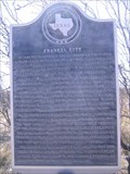 view gallery view galleryE37.3 km | Frankel City in Texas Historical Markers From Andrews, take U.S. 87 west about 12 miles to intersection of FM 181 and U.S. 87 posted by: GeoGrands location: Texas date approved: 02/04/2007 last visited: 10/05/2008 |
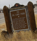 view gallery view galleryS37.8 km | Jal, NM State Park in New Mexico Historical Markers An OHSM For Jal state park posted by: kingbee location: New Mexico date approved: 12/25/2010 last visited: 01/06/2012 |
 view gallery view galleryS44.3 km |  Eleganza II - Jal, NM Eleganza II - Jal, NM
in Abandoned Dead Vehicles This GM Eleganza II Motor Coach has languished in the New Mexico desert for about a decade - near Jal, New Mexico. posted by: The Snowdog location: New Mexico date approved: 08/12/2024 last visited: never |
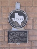 view gallery view galleryE44.4 km | Irwin Ranch House in Texas Historical Markers From Andrews, take U.S. 385 north about 7 miles, then go west on FM 1967 about 7 miles. posted by: GeoGrands location: Texas date approved: 02/04/2007 last visited: 08/18/2019 |
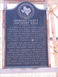 view gallery view galleryE48.6 km | Andrews County Discovery Well in Texas Historical Markers From Andrews, take Hwy. 87 West about 5 miles. posted by: GeoGrands location: Texas date approved: 02/04/2007 last visited: 02/03/2007 |
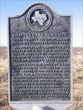 view gallery view galleryE48.8 km | Shafter Lake Townsite in Texas Historical Markers From Andrews, take US 385 north about 7 miles, then go west on FM 1967 about 6.75 miles. posted by: GeoGrands location: Texas date approved: 02/04/2007 last visited: 08/18/2019 |
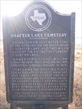 view gallery view galleryE48.9 km | Shafter Lake Cemetery in Texas Historical Markers From Andrews, take SH 385 north 7 miles, then go west on FM 1967 about 3.2 miles. Go south on CR NW 2001 about 1.6 mile. posted by: GeoGrands location: Texas date approved: 02/04/2007 last visited: 08/28/2008 |
 view gallery view galleryS49.7 km |  Southeast Corner of New Mexico (1912) - Jal, NM Southeast Corner of New Mexico (1912) - Jal, NM
in U.S. Historic Survey Stones and Monuments This marker established the southeast corner of New Mexico in 1912 - southeast of Jal, New Mexico. posted by: The Snowdog location: New Mexico date approved: 09/17/2024 last visited: never |
 view gallery view galleryS49.7 km |  Southeast Corner of New Mexico (1912) - Jal, NM Southeast Corner of New Mexico (1912) - Jal, NM
in Public Land Survey Marks This marker established the southeast corner of New Mexico in 1912 - southeast of Jal, New Mexico. posted by: The Snowdog location: New Mexico date approved: 08/12/2024 last visited: never |
 view gallery view galleryN54.7 km | Lovington - Lovington, NM in New Mexico Historical Markers This historical marker on the south side of Lovington, New Mexico provides a brief history of the city. posted by: The Snowdog location: New Mexico date approved: 12/18/2019 last visited: never |
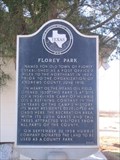 view gallery view galleryE55.2 km | Florey Park in Texas Historical Markers From Andrews, take U.S. 385 north about 10 miles to Florey, then go 1 mile east on Florey Park Rd. posted by: GeoGrands location: Texas date approved: 02/04/2007 last visited: 09/29/2007 |
 view gallery view galleryS56.3 km | Sand Hills in Texas Historical Markers From Kermit, take SH 115 NE about 8 miles. Half a mile or so north of the junction with FM 874. posted by: GeoGrands location: Texas date approved: 01/27/2007 last visited: 12/22/2013 |
|