 view gallery view gallery NW2.3 km NW2.3 km
|   Mount Lemmon Ski Lift - Mount Lemmon, AZ Mount Lemmon Ski Lift - Mount Lemmon, AZ
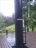
in Elevation Signs Lower Ski Lift at Mount Lemmon, AZ elevation sign 8,225ft. posted by:  philbeer philbeer location: Arizona date approved: 07/17/2013 last visited: 11/28/2014 |
 view gallery view galleryNW2.3 km |  Mount Lemmon Ski Lift - Mount Lemmon, AZ Mount Lemmon Ski Lift - Mount Lemmon, AZ
in Aerial Lifts Ski Lift at Mount Lemmon, AZ posted by: philbeer location: Arizona date approved: 07/15/2013 last visited: 09/05/2022 |
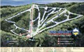
 view gallery view galleryNW2.3 km |  Ski Valley, Mt Lemmon, AZ Ski Valley, Mt Lemmon, AZ
in Ski Lodges Ski Valley can be found on Mt Lemmon in Mt Lemmon, AZ posted by: Poehunters location: Arizona date approved: 08/16/2013 last visited: 08/08/2021 |
 view gallery view gallery W2.7 km W2.7 km
|  Santa Catalina Mountains - Tucsonopoly - Tucson, AZ Santa Catalina Mountains - Tucsonopoly - Tucson, AZ
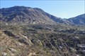
in Monopoly in the Real World The Catalina Mountains are located on the north and northeast side of Tucson posted by: Max and 99 location: Oklahoma date approved: 01/21/2020 last visited: never |
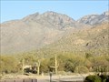
 view gallery view galleryW2.7 km |  Mount Lemmon, highest point in Pima County, Arizona Mount Lemmon, highest point in Pima County, Arizona
in Geographic High Points Mount Lemmon, at over 9,000', is the highest point in Pima County. posted by: tugies location: Arizona date approved: 12/18/2013 last visited: 09/09/2019 |
 view gallery view galleryW2.7 km |  Lemmon Rock Lookout House Lemmon Rock Lookout House
in Civilian Conservation Corps Lemmon Rock Lookout House was built in the 1930s by the Civilian Conservation Corp. posted by: rambles location: Arizona date approved: 08/25/2008 last visited: 07/05/2013 |
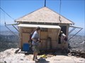 view gallery view galleryW2.7 km |  Lemmon Rock Lookout House Lemmon Rock Lookout House
in U.S. National Register of Historic Places This lookout was built on Mt Lemmon just south of the summit on Lemmon Rock. It has been staffed for 70 years
posted by: rambles location: Arizona date approved: 07/08/2008 last visited: 07/13/2013 |
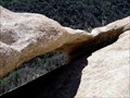 view gallery view gallery N3.4 km N3.4 km
|  Reef of Rock Natural Arch Reef of Rock Natural Arch
in Natural Arches A small natural arch located north of Mt. Lemmon, AZ posted by: TucsonThompsen location: Arizona date approved: 09/14/2011 last visited: 12/15/2014 |
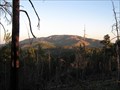
 view gallery view gallery SE4.2 km SE4.2 km
|  Plane Crash on Mt. Bigelow Plane Crash on Mt. Bigelow
in Plane Crash Sites Late in the afternoon of 8 July 1957, two F-86 Saberjet fighter aircraft from Davis-Monthan Air Force Base met in a midair collision in
the sky over Mount Bigelow. posted by: Poehunters location: Arizona date approved: 06/26/2013 last visited: 06/11/2021 |
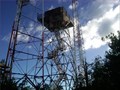 view gallery view gallerySE5 km |  Mt Bigelow Fire Tower Mt Bigelow Fire Tower
in Look-Out Towers This is the Bigelow Mountain fire-lookout tower Near Mt. Lemmon, AZ posted by: TucsonThompsen location: Arizona date approved: 06/15/2010 last visited: 07/05/2013 |
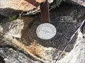
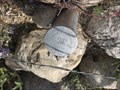
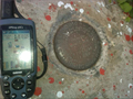 view gallery view gallerySE5 km |  BIGELOW Benchmark BIGELOW Benchmark
in U.S. Benchmarks This the benchmark atop Mt Bigelow in the Catalina Mountains outside of Tucson, AZ. posted by: TucsonThompsen location: Arizona date approved: 06/19/2010 last visited: 07/17/2013 |
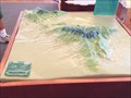 view gallery view gallerySE5.3 km |  Mt Lemmon 3D Map, Mt Lemmon, AZ Mt Lemmon 3D Map, Mt Lemmon, AZ
in 3D Map Models of Our World and Beyond This 3D Map of Mt Lemmon can be found at the Palisades Visitor Center along Catalina Highway about 20 miles up the road. posted by: Poehunters location: Arizona date approved: 07/19/2013 last visited: 08/29/2013 |
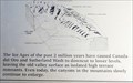
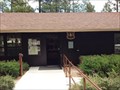 view gallery view gallerySE5.3 km |  Palisades Visitor Center, Mt Lemmon, AZ Palisades Visitor Center, Mt Lemmon, AZ
in Tourist Information Centers - Visitor Centers Just about 20 miles up the road , elevation 7,850 ft, the Forest Service partnering with PLIA, operates the Palisades Visitor Center. The center is a wonderful place to get information, buy books and other mementos. posted by: Poehunters location: Arizona date approved: 07/17/2013 last visited: 11/21/2013 |
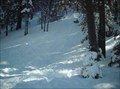 view gallery view gallerySE5.5 km |  Sledding at Bigelow Trailhead, Mt Lemmon, AZ Sledding at Bigelow Trailhead, Mt Lemmon, AZ
in Sledding Places This is a great sledding area in the winter near the Mt Bigelow trail head in Mt Lemmon, AZ. posted by: Poehunters location: Arizona date approved: 08/19/2013 last visited: 08/06/2021 |
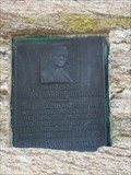 view gallery view gallerySE8.9 km |  Honorable Frank Harris Hitchcock - Tucson, AZ Honorable Frank Harris Hitchcock - Tucson, AZ
in Citizen Memorials This beautiful highway was made possible by his sincere interest and unceasing efforts. It is dedicated to him and shall be known as
"Hitchcock Highway" posted by:  leadhiker leadhiker location: Arizona date approved: 05/25/2010 last visited: 01/03/2019 |
 view gallery view galleryNW10 km |  Charouleau Gap - Arizona Charouleau Gap - Arizona
in Named Mountain Gaps A 4WD road takes you to Charouleau Gap at the northern part of the Santa Catalina Mountains of Southern Arizona. posted by: Team2002 location: Arizona date approved: 01/25/2012 last visited: 09/23/2021 |
 view gallery view gallery NE10.8 km NE10.8 km
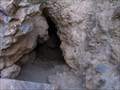
| Pepper Sauce Cave Entrance (Natural), Oracle, AZ in Cave Entrances (Natural) This natural cave entrance is for Pepper Sauce Cave located on Mt Lemmon Road in the Coronado National Forest in Oracle, AZ. posted by: Poehunters location: Arizona date approved: 08/16/2013 last visited: 08/16/2013 |
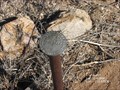
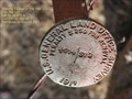
 view gallery view galleryW10.9 km |  AZ Township 11S 14E 1/4 section between section 25 & 26 AZ Township 11S 14E 1/4 section between section 25 & 26
in Public Land Survey Marks 1911 AZ Township 11S 14E 1/4 section marker between sections 25 and 26 posted by: ccprob location: Arizona date approved: 12/23/2012 last visited: never |
 view gallery view galleryW11.1 km | AZ Township 11S 14E 1/4 section between sections 23 and 24 in Public Land Survey Marks 1911 AZ marker for Township 11S 14E 1/4 section between sections 23 and 24. posted by: ccprob location: Arizona date approved: 12/29/2012 last visited: never |
 view gallery view galleryW11.6 km | AZ Township 11S 14E 1/4 section between sections 13 and 14 in Public Land Survey Marks 1911 original survey 1/4 section marker between sections 13 and 14 in AZ township 11S 14E. posted by: ccprob location: Arizona date approved: 11/25/2012 last visited: never |
 view gallery view gallery S11.7 km S11.7 km
|  Catalina Federal Honor Camp Catalina Federal Honor Camp
in World War II Sites Why Put A Prison On A Mountain? posted by: leadhiker location: Arizona date approved: 06/14/2011 last visited: 01/03/2019 |
 view gallery view galleryNW11.9 km | AZ Township 11S 14E corner of Sections 11, 12, 13 & 14 in Public Land Survey Marks AZ Township 1911 marker 11S 14E corner of Sections 11, 12, 13 & 14 posted by: ccprob location: Arizona date approved: 01/04/2013 last visited: never |
 view gallery view galleryW12.6 km | AZ Township 11S 1E corner between sections 22, 27, 23, 26 in Public Land Survey Marks AZ Township 11S 1E corner between sections 22, 27, 23, 26. Replacement marker dated 1994 posted by: ccprob location: Arizona date approved: 01/04/2013 last visited: never |
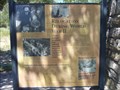
 view gallery view gallerySE13 km |  You Are Here - Molino Basin Trailhead, Mt. Lemmon, AZ You Are Here - Molino Basin Trailhead, Mt. Lemmon, AZ
in 'You Are Here' Maps A "You Are Here" sign at the Molino Basin trailhead on Mount Lemmon, near Tucson, Arizona posted by: The Snowdog location: Arizona date approved: 02/09/2019 last visited: never |
 view gallery view galleryW13.2 km | Geology of the Catalina Mounts, You Are Here, Catalina State Park - Tucson, AZ in 'You Are Here' Maps This You Are Here sign locates the visitor to their position in the geological development of the Catalina Mountains north of Tucson, Arizona. posted by: rjmcdonough1 location: Arizona date approved: 03/29/2018 last visited: 11/13/2019 |
|