 view gallery view gallery SE1.6 km SE1.6 km
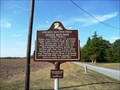
|   Insley Mounds: Ancient Mounds Trail Insley Mounds: Ancient Mounds Trail
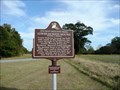
in Louisiana Historical Markers Marker on Frankie Loftin Road, 1.4 mi from Martin Road, off of La 17 South of Delhi posted by:  kwashnak kwashnak location: Louisiana date approved: 11/14/2010 last visited: never |
 view gallery view gallery N6.3 km N6.3 km
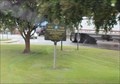
|  MoPac 13497 -- Delhi LA MoPac 13497 -- Delhi LA
in Train Cabooses Old Missouri Pacific RR caboose 13497 is on permanent display at the old Delhi depot, which now serves as the Delhi visitor center. Apparently, this caboose started life on the Chicago and Eastern Illinois (C&EI) RR. posted by:  Benchmark Blasterz Benchmark Blasterz location: Louisiana date approved: 09/22/2014 last visited: 09/24/2014 |
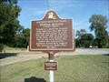
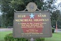
 view gallery view galleryN6.3 km |  LA SH 17 N of US 80 to Epps -- Delhi LA LA SH 17 N of US 80 to Epps -- Delhi LA
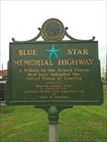
in Blue Star Memorial Highway Markers Louisiana State Highway 17 from the US 80 north to Epps LA is a Blue star Memorial Highway. posted by: Benchmark Blasterz location: Louisiana date approved: 09/16/2014 last visited: 09/17/2014 |
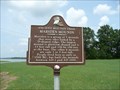 view gallery view galleryN9.7 km | Marsden Mounds in Louisiana Historical Markers The Marsden Mounds are located in the Poverty Point Reservoir State Park, 0.3 miles from the entrance in a pull off on the right side of Poverty Point Parkway. Admission is charged to the park. posted by: kwashnak location: Louisiana date approved: 07/21/2011 last visited: never |
 view gallery view gallery E11.6 km E11.6 km
| Tendal Mound: Ancient Mounds Trail in Louisiana Historical Markers Ancient Mound Trail - Located 11.8 miles West Tallulah on US 80. posted by: kwashnak location: Louisiana date approved: 09/23/2010 last visited: 09/18/2015 |
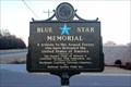
 view gallery view galleryN22.7 km | LA SH 17 between Delhi and Epps -- Epps LA in Blue Star Memorial Highway Markers Louisiana State Highway 17 between Delhi and Epps is a Blue Star Memorial Highway posted by: Benchmark Blasterz location: Louisiana date approved: 09/15/2014 last visited: 09/17/2014 |
 view gallery view galleryN25.4 km | Lower Jackson Mounds: Ancient Mounds Trail in Louisiana Historical Markers Marker on Walnut Grove Lane, just off of LA 134 north of Epps near Poverty Point posted by: kwashnak location: Louisiana date approved: 11/14/2010 last visited: 08/30/2014 |
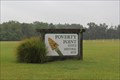
 view gallery view galleryN25.6 km |  Poverty Point National Monument - Delhi, LA Poverty Point National Monument - Delhi, LA
in U.S. National Register of Historic Places Located in northeastern Louisiana, Poverty Point commemorates a culture that thrived during the first and second millennia B.C. This site, which contains some of the largest prehistoric earth works in North America. posted by: nomadwillie location: Louisiana date approved: 06/25/2009 last visited: 07/03/2017 |
 view gallery view galleryN25.6 km |  Poverty Point Poverty Point
in Wikipedia Entries Located in northeastern Louisiana, Poverty Point commemorates a culture that thrived during the first and second millennia B.C. This site, which contains some of the largest prehistoric earth works in North America. posted by: nomadwillie location: Louisiana date approved: 12/17/2009 last visited: 07/03/2017 |
 view gallery view galleryN25.6 km | Poverty Point National Monument - Delhi, LA in Louisiana Historical Markers Located at the intersection of Hwy 577 and 134 in Epps LA posted by: nomadwillie location: Louisiana date approved: 12/20/2009 last visited: 07/03/2017 |
 view gallery view gallery W26.1 km W26.1 km
| U.S. 425, Northeast Louisiana Veterans Cemetery, Rayville, LA in Blue Star Memorial Highway Markers Located south of I-20 on US 425 at the entrance to the cemetery. posted by: Markerman62 location: Louisiana date approved: 12/23/2019 last visited: 12/23/2019 |
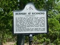 view gallery view galleryE26.2 km | Skirmish at Richmond in Louisiana Historical Markers Richmond was a community outside of Tallulah, Louisiana which was destroyed during the Civil War. A pair of markers note the site and events. Hwy 603, Tallulah. 0.7 mi south of I20 underpass. posted by: kwashnak location: Louisiana date approved: 12/21/2011 last visited: 08/25/2019 |
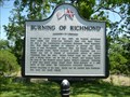 view gallery view galleryE26.2 km | Burning of Richmond in Louisiana Historical Markers Richmond was a community outside of Tallulah, Louisiana which was destroyed during the Civil War. A pair of markers note the site and events. Hwy 603, Tallulah. 0.7 mi south of I20 underpass. posted by: kwashnak location: Louisiana date approved: 12/21/2011 last visited: 08/25/2019 |
 view gallery view galleryW26.4 km |  Subway - Louisa St. - Rayville, LA Subway - Louisa St. - Rayville, LA
in Subway Restaurants Subway located inside the Chevron Station on Louisa St. at I-20, Rayville, LA. posted by: Lat34North location: Louisiana date approved: 10/25/2009 last visited: 08/30/2014 |
 view gallery view galleryW26.9 km | Nonnie Roark Rhymes Memorial Library -- Rayville LA in U.S. National Register of Historic Places The Nonnie Roark Rhymes Memorial Library in Rayville is on the US National Register of Historic Places. It is also known as the Richland parish Library. posted by: Benchmark Blasterz location: Louisiana date approved: 09/13/2014 last visited: 09/15/2014 |
 view gallery view galleryW26.9 km |  FIRST -- Parish Library in Louisiana, Rayville LA FIRST -- Parish Library in Louisiana, Rayville LA
in First of its Kind The Richland Parish Library is the first parish library in the state of Louisiana. posted by: Benchmark Blasterz location: Louisiana date approved: 09/13/2014 last visited: 09/15/2014 |
 view gallery view galleryW26.9 km |  Walmart Supercenter #1109 - Rayville, LA Walmart Supercenter #1109 - Rayville, LA
in WAL*MART Stores A Walmart Supercenter in Rayville, LA posted by: lovorn location: Louisiana date approved: 10/31/2011 last visited: 08/30/2014 |
 view gallery view galleryW27 km | Harrison St. - Rayville, Louisiana in Blue Star Memorial Highway Markers Rayville, Louisiana Blue Star Memorial Marker posted by: Divecontom location: Louisiana date approved: 02/24/2015 last visited: 08/28/2014 |
 view gallery view galleryE27 km |  Love's Truck Stop - Tallulah. LA Love's Truck Stop - Tallulah. LA
in Truck Stops A Love's Truck Stop on I-20 at Exit 171 posted by: lovorn location: Louisiana date approved: 10/23/2011 last visited: 09/01/2014 |
 view gallery view galleryE27 km |  Arby's - Hwy 65 S - Richmond, LA Arby's - Hwy 65 S - Richmond, LA
in Arby's Restaurants An Arby's at the Love's Truck Stop in Richmond, LA posted by: lovorn location: Louisiana date approved: 12/26/2011 last visited: 09/01/2014 |
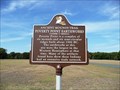 view gallery view galleryN27.4 km | Poverty Point Earthworks: Ancient Mounds Trail in Louisiana Historical Markers Marker on LA 577 just North of entrance to Poverty Point visitor's Center. posted by: kwashnak location: Louisiana date approved: 11/14/2010 last visited: 07/03/2017 |
 view gallery view galleryN27.4 km |  Monumental Earthworks of Poverty Point -- nr Pioneer LA Monumental Earthworks of Poverty Point -- nr Pioneer LA
in World Heritage Sites Poverty Point was named a UNESCO World Heritage Site on 22 Jun 2014. When Blasters were there in Aug 2014, the plaque had not arrived yet. posted by: Benchmark Blasterz location: Louisiana date approved: 09/14/2014 last visited: 07/03/2017 |
 view gallery view galleryN27.4 km |  Louisiana's Poverty Point earthworks named a UNESCO world heritage site -- near Pioneer LA Louisiana's Poverty Point earthworks named a UNESCO world heritage site -- near Pioneer LA
in News Article Locations When Louisiana's Poverty Point State Historic Site was named a World Heritage Site, it made not just national, but INTERNATIONAL news. posted by: Benchmark Blasterz location: Louisiana date approved: 09/13/2014 last visited: 07/03/2017 |
 view gallery view galleryN27.4 km |  Monumental Earthworks of Poverty Point -- nr Pioneer LA Monumental Earthworks of Poverty Point -- nr Pioneer LA
in New World Ancient Evidence Native people have been living at Poverty Point for 3000 years. Poverty Point was named the 22nd World Heritage Site in the US by the UNESCO on 22 June 2014. posted by: Benchmark Blasterz location: Louisiana date approved: 09/13/2014 last visited: 07/03/2017 |
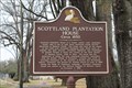 view gallery view galleryE27.4 km | Scottland Plantation House - Tallulah, LA in Louisiana Historical Markers Scottland Plantation House Marker on Highway 65 at Virginia Street in Tallulah, LA posted by: kwashnak location: Louisiana date approved: 04/17/2014 last visited: 08/25/2019 |
|