  N8.4 km N8.4 km
|   Kitchen Express Kitchen Express
in Classic BBQ and Sandwich Joints A permanent Roach Coach in Eunice posted by:  Team Simber Team Simber location: New Mexico date approved: 04/04/2007 last visited: never |
 view gallery view gallery S29 km S29 km
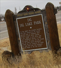
|  Jal, NM State Park Jal, NM State Park
in New Mexico Historical Markers An OHSM For Jal state park posted by: kingbee location: New Mexico date approved: 12/25/2010 last visited: 01/06/2012 |
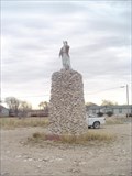 view gallery view galleryN31.1 km | The Monument at Monument in New Mexico Historical Markers "Geronimo" stands atop the monument at Monument. posted by: BewareOfPenguin location: New Mexico date approved: 01/06/2008 last visited: 12/18/2015 |
 view gallery view gallery E32.5 km E32.5 km
|  Andrews County Andrews County
in Texas Historical Markers From Andrews, take FM 87 West about 13 miles to roadside park. posted by:  GeoGrands GeoGrands location: Texas date approved: 02/04/2007 last visited: 09/29/2007 |
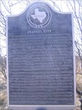 view gallery view galleryE35.6 km | Frankel City in Texas Historical Markers From Andrews, take U.S. 87 west about 12 miles to intersection of FM 181 and U.S. 87 posted by: GeoGrands location: Texas date approved: 02/04/2007 last visited: 10/05/2008 |
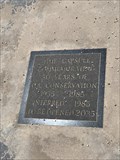 view gallery view galleryN35.9 km |  Commemorating 50 Years — Hobbs, NM Commemorating 50 Years — Hobbs, NM
in Time Capsules Commemorating oil conservation posted by: OcrazyS location: New Mexico date approved: 08/21/2019 last visited: never |
 view gallery view galleryN37.5 km | Hobbs, NM in New Mexico Historical Markers Named for the family of James Hobbs which homesteaded here in 1907, Hobbs became first a trading village for ranchers and then a major oil town after the discovery of oil by the Midwest Oil Company in 1928. posted by: BewareOfPenguin location: New Mexico date approved: 01/04/2008 last visited: 12/18/2015 |
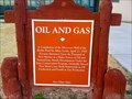 view gallery view galleryN41.2 km | Oil and Gas in New Mexico Historical Markers An Official Historical Scenic Marker honoring completion of the Discovery Well of the Hobbs Pool. posted by: Aarky location: New Mexico date approved: 12/24/2010 last visited: 12/18/2015 |
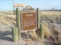
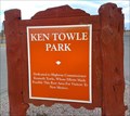 view gallery view galleryN41.2 km | Ken Towle Park in New Mexico Historical Markers A roadside marker honoring highway commissioner Kenneth Towle. posted by: Aarky location: New Mexico date approved: 12/24/2010 last visited: 02/02/2020 |
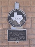 view gallery view galleryE43.9 km | Irwin Ranch House in Texas Historical Markers From Andrews, take U.S. 385 north about 7 miles, then go west on FM 1967 about 7 miles. posted by: GeoGrands location: Texas date approved: 02/04/2007 last visited: 08/18/2019 |
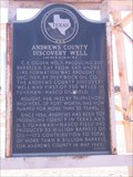 view gallery view galleryE46.5 km | Andrews County Discovery Well in Texas Historical Markers From Andrews, take Hwy. 87 West about 5 miles. posted by: GeoGrands location: Texas date approved: 02/04/2007 last visited: 02/03/2007 |
 view gallery view galleryS47.6 km | Sand Hills in Texas Historical Markers From Kermit, take SH 115 NE about 8 miles. Half a mile or so north of the junction with FM 874. posted by: GeoGrands location: Texas date approved: 01/27/2007 last visited: 12/22/2013 |
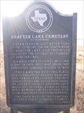 view gallery view galleryE48.1 km | Shafter Lake Cemetery in Texas Historical Markers From Andrews, take SH 385 north 7 miles, then go west on FM 1967 about 3.2 miles. Go south on CR NW 2001 about 1.6 mile. posted by: GeoGrands location: Texas date approved: 02/04/2007 last visited: 08/28/2008 |
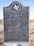 view gallery view galleryE48.1 km | Shafter Lake Townsite in Texas Historical Markers From Andrews, take US 385 north about 7 miles, then go west on FM 1967 about 6.75 miles. posted by: GeoGrands location: Texas date approved: 02/04/2007 last visited: 08/18/2019 |
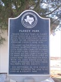 view gallery view galleryE55.7 km | Florey Park in Texas Historical Markers From Andrews, take U.S. 385 north about 10 miles to Florey, then go 1 mile east on Florey Park Rd. posted by: GeoGrands location: Texas date approved: 02/04/2007 last visited: 09/29/2007 |
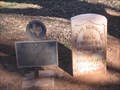 view gallery view galleryE55.7 km | Dorsie M. Pinnell in Texas Historical Markers The low grave marker is in Andrews County Cemetery, US 176 W. Within city limits, Andrews. The entrance from highway is signed Old Cemetery, take left hand road once inside gate. posted by: GeoGrands location: Texas date approved: 02/04/2007 last visited: 12/29/2014 |
 view gallery view galleryS56.2 km |  Desert Storm - Kermit, TX Desert Storm - Kermit, TX
in Murals This magnificent mural depicts Kermit as an oil boom town caught in a desert storm. posted by: The Snowdog location: Texas date approved: 05/29/2022 last visited: never |
 view gallery view galleryS56.2 km |  Heritage Park Engraved Bricks - Kermit, TX Heritage Park Engraved Bricks - Kermit, TX
in Donated Engraved Bricks and Pavers Donated engraved bricks form the wall under a magnificent mural in Heritage Park - in Kermit, Texas. posted by: The Snowdog location: Texas date approved: 05/28/2022 last visited: never |
 view gallery view galleryS56.2 km |  Heritage Park - Kermit, TX Heritage Park - Kermit, TX
in Municipal Parks and Plazas Heritage Park is just north of the Winkler County Courthouse - in Kermit, Texas. posted by: The Snowdog location: Texas date approved: 05/30/2022 last visited: never |
 view gallery view galleryS56.2 km |  Winkler County Courthouse -- Kermit TX Winkler County Courthouse -- Kermit TX
in Courthouses The lovely Beaux-Arts Winkler County Courthouse in downtown Kermit TX posted by: Benchmark Blasterz location: Texas date approved: 03/04/2014 last visited: 05/28/2022 |
 view gallery view galleryS56.2 km |  D.C. -- Kermit TX D.C. -- Kermit TX
in Animal Memorials The grave of D.C., the much loved Winkler Co. Courthouse Cat, occupies a place of honor on the Winkler County Courthouse grounds, so he can still be near his friends who pass by every day. posted by: Benchmark Blasterz location: Texas date approved: 03/08/2014 last visited: 05/28/2022 |
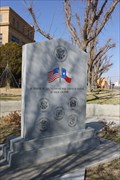 view gallery view galleryS56.2 km |  Winkler County Veterans Memorial -- Kermit TX Winkler County Veterans Memorial -- Kermit TX
in Non-Specific Veteran Memorials The beautiful and patriotic Winkler County Veteran's Memorial on the southeast corner of the Winkler County Courthouse grounds posted by: Benchmark Blasterz location: Texas date approved: 03/04/2014 last visited: 05/28/2022 |
 view gallery view galleryS56.2 km |  TX SH 18 at S Winkler St -- Kermit TX TX SH 18 at S Winkler St -- Kermit TX
in Blue Star Memorial Highway Markers TX 18 through Kermit TX is a Blue Star Memorial Highway. posted by: Benchmark Blasterz location: Texas date approved: 03/04/2014 last visited: 05/28/2022 |
 view gallery view galleryE56.2 km | Lakeside Park - Andrews, TX in Municipal Parks and Plazas City park that takes up 3 city blocks on the north side of Andrews. Has a duck pond with a waterfall and is circled by a walking path. posted by: WalksfarTX location: Texas date approved: 04/08/2016 last visited: never |
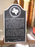 view gallery view galleryS56.2 km | MOVED - Old Wink Cemetery in Texas Historical Markers Located on an easel inside the south entrance of the Winkler County Courthouse, Kermit TX. posted by: GeoGrands location: Texas date approved: 01/26/2007 last visited: 03/14/2014 |
|