 view gallery view gallery N8.9 km N8.9 km
|   Autaugaville, AL - 36003 Autaugaville, AL - 36003
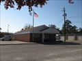
in U.S. Post Offices The Autaugaville post office is located at 105 North Taylor Street, near the intersection with Alabama Highway 14. posted by:  xptwo xptwo location: Alabama date approved: 11/09/2011 last visited: never |
 view gallery view galleryN8.9 km |  Autaugaville - Autaugaville, Alabama Autaugaville - Autaugaville, Alabama
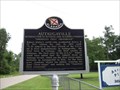
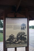
in Alabama Historical Markers Marker noting the 1935 Autaugaville, Alabama, mention in Ripley's Believe It Or Not! column. posted by: xptwo location: Alabama date approved: 06/11/2012 last visited: 09/26/2013 |
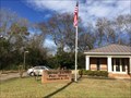
 view gallery view galleryN8.9 km |  Autaugaville Public Library - Autaugaville, Alabama Autaugaville Public Library - Autaugaville, Alabama
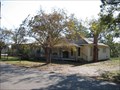
in Libraries The Autaugaville Public Library is a branch of the Autauga Prattville Public Libraries system. posted by: xptwo location: Alabama date approved: 11/07/2011 last visited: never |
 view gallery view galleryN9 km |  Autaugaville Baptist Church Bell - Autaugaville, AL Autaugaville Baptist Church Bell - Autaugaville, AL
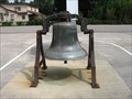
in Bells This bell is on display in the parking lot of Autaugaville Baptist Church. posted by: xptwo location: Alabama date approved: 11/13/2012 last visited: never |
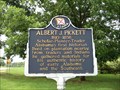 view gallery view galleryN9 km | Albert J. Pickett - Autaugaville, Alabama in Alabama Historical Markers Alabama's first historian is celebrated in this marker located west of Autaugaville, Alabama, along Alabama Highway 14. posted by: xptwo location: Alabama date approved: 06/18/2012 last visited: 09/26/2013 |
 view gallery view gallery SE9.8 km SE9.8 km
|  In Honor of Our Confederate Soldiers - Lowndesboro, AL In Honor of Our Confederate Soldiers - Lowndesboro, AL
in American Civil War Monuments and Memorials Located in the Oakview Cemetery on Broad Street, this is a memorial to the Confederate dead of Lowndesboro, AL. posted by:  hoteltwo hoteltwo location: Alabama date approved: 12/28/2013 last visited: never |
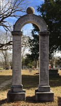
 view gallery view gallerySE9.8 km |  Alabama's First Capitol Dome - Lowndesboro, Alabama Alabama's First Capitol Dome - Lowndesboro, Alabama
in Unique Steeples What makes this steeple unique is that it has the cupola from the first Capitol of the State of Alabama. It is the only known remnant of that building. posted by: xptwo location: Alabama date approved: 07/10/2012 last visited: never |
 view gallery view gallerySE9.8 km |  Alabama's First Capitol Dome - Lowndesboro, Alabama Alabama's First Capitol Dome - Lowndesboro, Alabama
in Preserved Architectural Remnants and Ruins The only remnant of the first Capitol of the State of Alabama is a cupola on a church in Lowndesboro, Alabama. posted by: xptwo location: Alabama date approved: 04/21/2012 last visited: never |
 view gallery view gallerySE10 km | Lowndesboro, AL 36752 in U.S. Post Offices This small town post office serves a population of around 140 in and around Lowndesboro. posted by: hoteltwo location: Alabama date approved: 12/28/2013 last visited: never |
 view gallery view gallerySE10 km | Lowndesboro, Alabama in Alabama Historical Markers Marker giving the history of the town of Lowndesboro, Alabama, which is located about 15 miles west of Montgomery. posted by: xptwo location: Alabama date approved: 04/23/2012 last visited: 12/27/2013 |
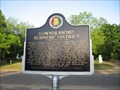 view gallery view gallerySE10 km | Lowndesboro Business District - Lowndesboro, Alabama in Alabama Historical Markers Marker giving the history of the business district in Lownedsboro, Alabama. posted by: xptwo location: Alabama date approved: 04/25/2012 last visited: 12/27/2013 |
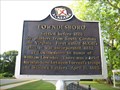 view gallery view gallerySE10.1 km | Lowndesboro, Alabama in Alabama Historical Markers This marker is located on North Broad Street in front of Ruby S. Moore Park in the small town of Lowndesboro. It has some of the early history of the town. posted by: xptwo location: Alabama date approved: 04/19/2012 last visited: 12/27/2013 |
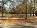 view gallery view gallerySE10.1 km |  Ruby S. Moore Park - Lowndesboro, AL Ruby S. Moore Park - Lowndesboro, AL
in Municipal Parks and Plazas Small town park in the middle of this historic district on North Broad Street. posted by: hoteltwo location: Alabama date approved: 12/28/2013 last visited: never |
 view gallery view gallery NE10.1 km NE10.1 km
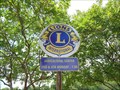
|  Lions Club - Autaugaville, AL Lions Club - Autaugaville, AL
in Lions Clubs International Markers This Lions Club logo next to the Welcome to Autaugaville sign tells the location and times when the local club meets. posted by: xptwo location: Alabama date approved: 06/05/2013 last visited: never |
 view gallery view galleryNE10.1 km |  Autaugaville, Alabama - Population 1,099 Autaugaville, Alabama - Population 1,099
in Population Signs The town of Autaugaville is located in Autauga County, Alabama, on Alabama Highway 14. The posted coordinates are for the welcome sign on the east side of town. posted by: xptwo location: Alabama date approved: 12/20/2011 last visited: never |
 view gallery view galleryNE10.1 km |  "Land of Good Living" - Autaugaville, Alabama "Land of Good Living" - Autaugaville, Alabama
in Welcome Signs The town of Autaugaville is located in Autauga County, Alabama, on Alabama Highway 14. The posted coordinates are for the welcome sign on the east side of town. posted by: xptwo location: Alabama date approved: 11/06/2011 last visited: never |
 view gallery view gallery S10.5 km S10.5 km
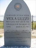
|  Viola Liuzzo Memorial Viola Liuzzo Memorial
in Civil Rights Memorials The Viola Liuzzo Memorial along US Highway 80 (mile marker 111) marks the place where the civil rights worker was shot and killed. posted by: xptwo location: Alabama date approved: 10/16/2011 last visited: 07/26/2017 |
 view gallery view galleryS10.5 km |  Viola Liuzzo Murder Site -- Lowndes Co. AL Viola Liuzzo Murder Site -- Lowndes Co. AL
in Infamous Crime Scenes A memorial at the spot where Viola Liuzzo, who was transporting local civil rights activists back to Selma, was shot and killed by the Ku Klux Klan posted by: Benchmark Blasterz location: Alabama date approved: 08/25/2017 last visited: 07/26/2017 |
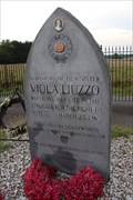
 view gallery view galleryS10.5 km |  Viola Liuzzo Memorial - Lowndes County, Alabama Viola Liuzzo Memorial - Lowndes County, Alabama
in Citizen Memorials The Viola Liuzzo Memorial along US Highway 80 (mile marker 111) marks the place where the civil rights worker was shot and killed. posted by: xptwo location: Alabama date approved: 03/29/2012 last visited: 07/26/2017 |
 view gallery view galleryS10.5 km |  Viola Liuzzo Memorial - Lowndes County, Alabama Viola Liuzzo Memorial - Lowndes County, Alabama
in National Scenic Byways The Viola Liuzzo Memorial along US Highway 80 (mile marker 111) marks the place where the civil rights worker was shot and killed. posted by: xptwo location: Alabama date approved: 01/06/2012 last visited: 07/26/2017 |
 view gallery view gallery SW10.6 km SW10.6 km
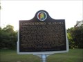
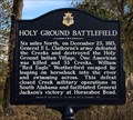
| Holy Ground Battlefield - White Hall, AL in Alabama Historical Markers Marker providing a short history of an Indian battle near the Alabama River. The movement, started by the Prophet Josiah Francis, and his Red Sticks were nearly annihilated. posted by: hoteltwo location: Alabama date approved: 12/27/2013 last visited: never |
 view gallery view gallerySW10.6 km |  Selma to Montgomery NHT - Lowndes County AL Selma to Montgomery NHT - Lowndes County AL
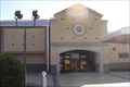
in NPS Passport Cancellation Stations The stamp is located at the visitor center located in White Hall, AL on US 80. This is the location of Tent City. posted by: nomadwillie location: Alabama date approved: 07/09/2009 last visited: 07/27/2017 |
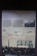 view gallery view gallerySW10.6 km |  "It started in Selma" -- Lowndes Interpretive Center, Lowndes Co. AL "It started in Selma" -- Lowndes Interpretive Center, Lowndes Co. AL
in Signs of History The sign of history outside of the Lowndes County Interpretive Center explains he genesis of the Selma to Montgomery Voting Rights March posted by: Benchmark Blasterz location: Alabama date approved: 09/02/2017 last visited: 01/17/2022 |
 view gallery view gallerySW10.6 km | "After the March -- Tent City" -- Lowndes Interpretive Center, Lowndes Co. AL in Signs of History The sign of history outside of the Lowndes County interpretive center explains what happened after the end of the Selma to Montgomery Voting Rights march posted by: Benchmark Blasterz location: Alabama date approved: 09/02/2017 last visited: 01/17/2022 |
 view gallery view gallerySW10.6 km | Selma to Montgomery March Byway-Lowndes County Interpretive Center in National Scenic Byways The Lowndes County Interpretive Center is about half way along the 54-mile stretch of highway of the 1965 Selma to Montgomery March. posted by: OHail location: Alabama date approved: 12/14/2011 last visited: 07/01/2023 |
|