 view gallery view gallery W7.4 km W7.4 km
|   R 28 ER 29 E R 28 ER 29 E
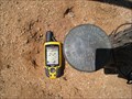
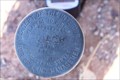
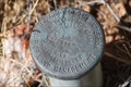
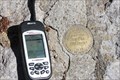
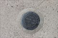
in U.S. Benchmarks Pipe cap benckmark 4 miles south of Bowie, AZ posted by:  The Coroner The Coroner location: Arizona date approved: 06/04/2010 last visited: 06/03/2013 |
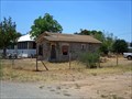
 view gallery view galleryW9 km |  Birthplace of Rambo (Mural) - Bowie, AZ Birthplace of Rambo (Mural) - Bowie, AZ
in Roadside Attractions John Rambo was born in Bowie, AZ posted by: Max and 99 location: Arizona date approved: 01/20/2020 last visited: never |
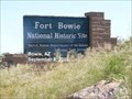
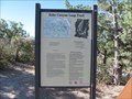
 view gallery view galleryW12.1 km |  Old Fort Bowie Old Fort Bowie
in Arizona Historical Markers Fort Bowie commemorates the bitter conflict between Chiricahua Apaches and the U.S. military. posted by:  leadhiker leadhiker location: Arizona date approved: 06/15/2011 last visited: 06/23/2014 |
 view gallery view galleryW12.4 km |  Bowie, Arizona Bowie, Arizona
in Wikipedia Entries Bowie is a census designated place in southeastern Arizona. posted by: rjmcdonough1 location: Arizona date approved: 07/06/2020 last visited: never |
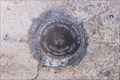 view gallery view galleryW12.6 km | Bowie High School - CY0675 in U.S. Benchmarks This bench mark is located on the North East side of the High School. The data sheet has the identifier for this bench mark as CY0675 posted by: outwest63 location: Arizona date approved: 11/04/2013 last visited: never |
 view gallery view gallery SW18.2 km SW18.2 km
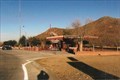
|  Fort Bowie National Historic Site - Bowie, AZ Fort Bowie National Historic Site - Bowie, AZ
in NPS Passport Cancellation Stations Fort Bowie witnessed almost 25 years of conflict between the Chiricahua Apache and the US Army, and remains a tangible connection to the turbulent era of the late 1800s. posted by: Don.Morfe location: Arizona date approved: 02/14/2020 last visited: 10/10/2021 |
 view gallery view gallery NW18.3 km NW18.3 km
|  T11S R28E - Central Road North of Bowie, Az. T11S R28E - Central Road North of Bowie, Az.
in Public Land Survey Marks Brass cap marker located next to cattle guard on Central Road North of Bowie, Az. posted by: outwest63 location: Arizona date approved: 04/17/2011 last visited: never |
 view gallery view gallerySW18.7 km | ") Fort Bowie National Historic Site - Arizona Fort Bowie National Historic Site - Arizona
in National Parks (U.S.) Fort Bowie once served as the headquarters of the US Army in its war against the Chiricahua Apaches. posted by: adenium location: Arizona date approved: 06/20/2012 last visited: 02/15/2022 |
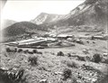 view gallery view gallerySW18.7 km |  Fort Bowie - Arizona Fort Bowie - Arizona
in Photos Then and Now Fort Bowie was an outpost of the US Army from 1862 to 1894. posted by: adenium location: Arizona date approved: 06/18/2012 last visited: 06/23/2014 |
 view gallery view gallerySW19 km |  Orisoba O. Spence-Bowie, AZ Orisoba O. Spence-Bowie, AZ
in Medal Of Honor Resting Places Indian Campaigns Medal of Honor Recipient for action at Chiricahua Mountains, AZ on October 20, 1869. His MOH citation spells his first name as Orizoba. He is buried in Fort Bowie Post Cemetery, Bowie, AZ in Section E-16, Grave 58. posted by: Don.Morfe location: Arizona date approved: 06/13/2018 last visited: 12/12/2021 |
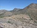
 view gallery view gallerySW20 km | T15S R28E Butterfield Stage Road to Ft. Bowie in Public Land Survey Marks This Cadastral survey marker is on the old Butterfield Stage Trail. It is located approximately 300 yards off the Apache Pass Road in Northern Cochise County. posted by: outwest63 location: Arizona date approved: 04/11/2011 last visited: never |
 view gallery view gallerySW20 km | Apache Pass (Fort Bowie National Historic Site)-Bowie, AZ in Arizona Historical Markers The route of historic Apache Pass – long abandoned and faint – is marked with posts. As you drive over the next 3 downward miles, contemplate what is must have been like over 100 years ago. posted by: Don.Morfe location: Arizona date approved: 11/28/2019 last visited: 10/23/2021 |
 view gallery view gallery E26.4 km E26.4 km
|  Percy Jones, Jr. - The San Simon Rest Area, Arizona Percy Jones, Jr. - The San Simon Rest Area, Arizona
in Citizen Memorials Dedicated to the Engineering Achievements of Percy Jones, Jr. posted by: YoSam. location: Arizona date approved: 02/22/2019 last visited: never |
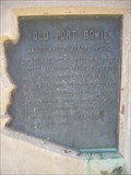
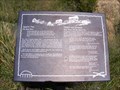
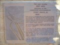
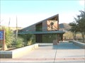
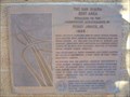 view gallery view galleryE26.4 km | The San Simon Rest Area in Arizona Historical Markers Dedicated to the
Engineering Achievements of
Percy Jones, Jr. posted by: leadhiker location: Arizona date approved: 06/15/2011 last visited: 02/22/2019 |
 view gallery view galleryE26.6 km |  San Simon rest areas reopen on I-10 in southeastern Arizona San Simon rest areas reopen on I-10 in southeastern Arizona
in News Article Locations Westbound side posted by: YoSam. location: Arizona date approved: 02/22/2019 last visited: never |
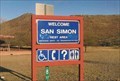 view gallery view galleryE26.6 km |  San Simon Rest Area, San Simon, AZ San Simon Rest Area, San Simon, AZ
in Free Overnight RV Parking Locations First rest area on I-10 as you enter Arizona from New Mexico. posted by: YoSam. location: Arizona date approved: 02/22/2019 last visited: 01/12/2020 |
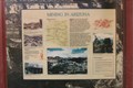 view gallery view galleryE26.6 km | Mining In Arizona - San Simon Rest Area, San Simon, AZ in Arizona Historical Markers Instructional - historical markers in the rest area. posted by: YoSam. location: Arizona date approved: 07/20/2016 last visited: 12/28/2018 |
 view gallery view galleryE26.6 km |  San Simon Rest Area, San Simon, AZ San Simon Rest Area, San Simon, AZ
in Highway Rest Areas First rest area on I-10 as you enter Arizona from New Mexico. posted by: YoSam. location: Arizona date approved: 03/22/2009 last visited: 06/03/2018 |
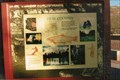 view gallery view galleryE26.6 km |  Arizona High Country - San Simon, AZ Arizona High Country - San Simon, AZ
in Flora and Fauna Information Signs Two markers mainly for flora and fauna. posted by: YoSam. location: Arizona date approved: 12/21/2021 last visited: never |
 view gallery view gallery S27.4 km S27.4 km
|  Cochise Head - Cochise County, Arizona Cochise Head - Cochise County, Arizona
in Simulacra The top of this mountain, known as Cochise Head Mountain, resembles the profile of Apache chief Cochise. posted by: adenium location: Arizona date approved: 06/18/2012 last visited: 09/02/2019 |
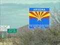 view gallery view galleryE30.3 km |  NM-AZ on I-10 NM-AZ on I-10
in Border Crossings This border crossing between New Mexico and Arizona is on I-10. If you want to take pictures, be prepared to take them 'on the fly'. posted by: PeterNoG location: Arizona date approved: 02/25/2011 last visited: 05/18/2023 |
 view gallery view galleryS31.1 km | 285+40 Bonita Canyon Road in U.S. Benchmarks Marker is located on Bonita Canyon Road in the Chiricahua National monument. posted by: outwest63 location: Arizona date approved: 05/10/2011 last visited: never |
 view gallery view galleryS32.3 km |  Echo Canyon Trailhead - Chiricahua National Monument - Arizona Echo Canyon Trailhead - Chiricahua National Monument - Arizona
in Hiking and walking trailheads A 2-mile loop trail in Chiricahua National Monument. posted by: adenium location: Arizona date approved: 06/18/2012 last visited: 09/02/2019 |
 view gallery view galleryS32.5 km | Faraway Ranch in U.S. Benchmarks Bench mark is located in the side walk for the Faraway Ranch homestead. posted by: outwest63 location: Arizona date approved: 10/22/2011 last visited: never |
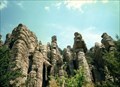 view gallery view galleryS32.7 km |  Chiricahua National Monument Historic Designed Landscape - Willcox AZ Chiricahua National Monument Historic Designed Landscape - Willcox AZ
in U.S. National Register of Historic Places Chiricahua National Monument is a unit of the National Park System located in the Chiricahua Mountains of southeastern Arizona. The monument was established on April 18, 1924, to protect its extensive hoodoos and balancing rocks. posted by: Don.Morfe location: Arizona date approved: 02/19/2022 last visited: 02/16/2022 |
|