 view gallery view gallery S1.4 km S1.4 km
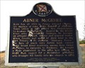
|   Abner McGehee - Hope Hull, AL Abner McGehee - Hope Hull, AL
in Alabama Historical Markers Located in the woods off Folmar Parkway, this cemetery and marker describes one of the early settlers of Hope Hull. posted by:  hoteltwo hoteltwo location: Alabama date approved: 12/28/2013 last visited: 07/25/2022 |
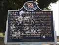 view gallery view galleryS1.4 km | Early Alabama Entrepreneur - Hope Hull, AL in Alabama Historical Markers Describes the farming and business sense of one of Hope Hull's early settlers, Abner McGehee. Marker located in the woods off a dirt road southwest of Folmar Parkway. posted by: hoteltwo location: Alabama date approved: 12/28/2013 last visited: 07/25/2022 |
 view gallery view gallery E2.3 km E2.3 km
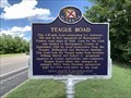
| Teague Road - Montgomery, AL in Alabama Historical Markers Located on Hyundai Boulevard at Mobile Highway (U.S. 31), Montgomery posted by:  Markerman62 Markerman62 location: Alabama date approved: 08/12/2022 last visited: never |
  N4.2 km N4.2 km
|  Montgomery Airport - Dannelly Field Montgomery Airport - Dannelly Field
in Wi-Fi Hotspots Free Wi-Fi located in passenger terminal. posted by: sealawyer98 location: Alabama date approved: 02/03/2009 last visited: 05/05/2022 |
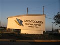 view gallery view galleryN4.2 km |  Montgomery Regional Airport - Montgomery, AL Montgomery Regional Airport - Montgomery, AL
in Airports Montgomery, the state capital of Alabama, is served by three main carriers: Delta Connection, US Airways Express, and American Eagle. posted by: xptwo location: Alabama date approved: 05/16/2012 last visited: 03/11/2015 |
 view gallery view galleryN4.2 km |  Montgomery Regional Airport - Montgomery, Alabama Montgomery Regional Airport - Montgomery, Alabama
in Inside Airports Originally built as Dannelly Field in 1943 by the Army Air Force, the location became the site of the Montgomery Regional Airport in 1946. There have been several expansions and renovations, with the most recent being completed in 2006. posted by: xptwo location: Alabama date approved: 06/25/2012 last visited: 05/05/2022 |
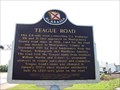 view gallery view galleryE6.3 km | Teague Road - Montgomery, Alabama in Alabama Historical Markers What probably started as a small country road is now a multi-lane highway thanks to the building of the Hyundai Plant in Montgomery County. This marker tells the history of the road. posted by: xptwo location: Alabama date approved: 06/19/2012 last visited: 07/25/2022 |
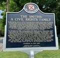 view gallery view galleryN7.9 km | The Smiths: A Civil Rights Family - Montgomery, AL in Alabama Historical Markers Located on Second Street, the historical marker honors three generations of the Smith family’s civil rights activism. posted by: hoteltwo location: Alabama date approved: 05/20/2023 last visited: never |
 view gallery view gallery NE7.9 km NE7.9 km
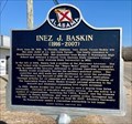
| Inez J. Baskin - Montgomery, AL in Alabama Historical Markers Inez Baskin was an American journalist and civil rights supporter who covered the Civil Rights Movement and the Montgomery bus boycott for African American readers and publications. posted by: hoteltwo location: Alabama date approved: 03/12/2024 last visited: never |
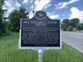 view gallery view galleryNE8 km | Rev. Richard C. Boone (1937-2013) - Montgomery, AL in Alabama Historical Markers Located on Mobile Highway near Young Drive, Montgomery posted by: Markerman62 location: Alabama date approved: 08/12/2022 last visited: never |
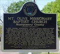 view gallery view galleryN9 km | Mt. Olive Missionary Baptist Church, Montgomery, AL in Alabama Historical Markers The Mt. Olive Missionary Baptist Church historical marker is located in front of the church on the south side of Old Selma Road. posted by: hummerstation location: Alabama date approved: 04/05/2024 last visited: never |
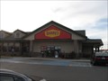
 view gallery view gallery SW9.2 km SW9.2 km
|  Dairy Queen - I-65 exit 158 - Hope Hull, Alabama Dairy Queen - I-65 exit 158 - Hope Hull, Alabama
in Dairy Queen Restaurants This Dairy Queen can be found at the BP Station on the east side of I-65 exit 158. posted by: xptwo location: Alabama date approved: 04/25/2012 last visited: never |
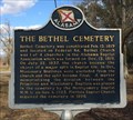 view gallery view galleryS9.3 km | The Bethel Cemetery - Pintlala, AL in Alabama Historical Markers Located along US 31, just north of County Road 24 (Federal Road), this historic cemetery had a difficult break in the church supporting it. posted by: hoteltwo location: Alabama date approved: 01/21/2014 last visited: never |
 view gallery view gallerySW9.3 km |  Flying J - Tyson Road - Hope Hull, Alabama Flying J - Tyson Road - Hope Hull, Alabama
in Truck Stops The Flying J Travel Center is located at exit 158 on I-65 near Hope Hull, Alabama. There is a Denny's at this location. posted by: xptwo location: Alabama date approved: 01/14/2012 last visited: never |
 view gallery view gallerySW9.3 km |  Denny's - Tyson Road - Hope Hull, Alabama Denny's - Tyson Road - Hope Hull, Alabama
in Denny's Restaurants This Denny's is located at the Flying J Truck Plaza near exit 158 on I-65. posted by: xptwo location: Alabama date approved: 12/04/2011 last visited: 12/05/2011 |
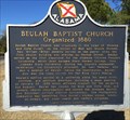 view gallery view galleryNE9.3 km | Beulah Baptist Church - Montgomery, AL in Alabama Historical Markers Marker describes the background of this church that was organized in 1880 and is located on Rosa L Parks Avenue. posted by: hoteltwo location: Alabama date approved: 01/20/2014 last visited: 07/25/2022 |
 view gallery view gallery SE10 km SE10 km
|  RAMM Field - Montgomery, Alabama RAMM Field - Montgomery, Alabama
in Model Aircraft Fields The Radio Aero Modelers Of Montgomery (RAMM) Field is located about five miles south of Montgomery, Alabama. posted by: xptwo location: Alabama date approved: 07/12/2012 last visited: never |
 view gallery view galleryN10.1 km |  Montgomery Goodwill Plant - Montgomery, AL Montgomery Goodwill Plant - Montgomery, AL
in Rotary International Markers The Goodwill buildings on Air Base Boulevard were donated in part by the Montgomery Rotary Club. posted by: xptwo location: Alabama date approved: 12/12/2012 last visited: never |
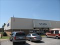
 view gallery view galleryN10.1 km |  Goodwill Air Base Blvd Thrift Store - Montgomery, AL Goodwill Air Base Blvd Thrift Store - Montgomery, AL
in Thrift Stores This Goodwill Retail Store and Donation Center is located on Air Base Boulevard in Montgomery, Alabama. posted by: xptwo location: Alabama date approved: 12/04/2012 last visited: never |
 view gallery view galleryN10.1 km |  Montgomery Goodwill Plant - Montgomery, AL Montgomery Goodwill Plant - Montgomery, AL
in Kiwanis International Markers The Goodwill building on Air Base Boulevard was donated in part by the Montgomery Kiwanis Club. The store has a sign saying it is the Montgomery Kiwanis Club Building. posted by: xptwo location: Alabama date approved: 12/02/2012 last visited: never |
 view gallery view galleryN10.1 km |  Goodwill Air Base Blvd Thrift Store - Montgomery, AL Goodwill Air Base Blvd Thrift Store - Montgomery, AL
in Permanent Charity Donation Locations This Goodwill Retail Store and Donation Center is located on Air Base Boulevard in Montgomery, Alabama. posted by: xptwo location: Alabama date approved: 12/20/2012 last visited: never |
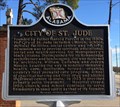 view gallery view galleryNE10.1 km | City of St. Jude - Montgomery, AL in Alabama Historical Markers Built as "the City of St. Jude" by Father Harold Purcell for the advancement of the Negro people. Was a campground for the Selma to Montgomery Civil Rights March in 1965. posted by: hoteltwo location: Alabama date approved: 01/04/2014 last visited: 07/25/2022 |
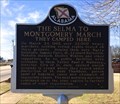 view gallery view galleryNE10.1 km | The Selma to Montgomery March - Montgomery, AL in Alabama Historical Markers Last location on the Selma to Montgomery Trail used as a campsite as part of the march to the Montgomery Capital in 1965. posted by: hoteltwo location: Alabama date approved: 01/04/2014 last visited: 07/25/2022 |
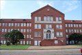 view gallery view galleryNE10.1 km |  Campsite 4 -- City of St. Jude, Selma-Montgomery March NHT, Montgomery AL Campsite 4 -- City of St. Jude, Selma-Montgomery March NHT, Montgomery AL
in National Scenic Byways The City of St. Jude on the west side of Montgomery served as Campsite No. 4 for weary marchers on the Selma to Montgomery Voting Rights march. posted by: Benchmark Blasterz location: Alabama date approved: 09/10/2017 last visited: 07/29/2017 |
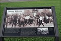 view gallery view galleryNE10.1 km |  Heroe's Welcome -- St. Jude's, Montgomery AL Heroe's Welcome -- St. Jude's, Montgomery AL
in Signs of History A second sign of history at the St. Jude's Catholic Complex on the western edge of Montgomery, the last overnight camp for the marchers on the Selma-Montgomery Voting Rights March posted by: Benchmark Blasterz location: Alabama date approved: 08/29/2017 last visited: 07/26/2017 |
|