 view gallery view gallery S12.1 km S12.1 km
|   Ghost Site Mounds: Ancient Mounds Trail Ghost Site Mounds: Ancient Mounds Trail
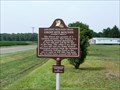
in Louisiana Historical Markers Ancient Mounds Trail marker on LA Highway 4, 0.4 miles east of LA 128 posted by:  kwashnak kwashnak location: Louisiana date approved: 08/11/2010 last visited: never |
 view gallery view gallery E16.9 km E16.9 km
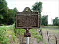
| Schackleford Church Mounds: Ancient Mounds Trail in Louisiana Historical Markers Ancient Mounds Trail marker - LA 575, 6.6 miles North of LA 4 posted by: kwashnak location: Louisiana date approved: 08/11/2010 last visited: never |
 view gallery view gallery N20.9 km N20.9 km
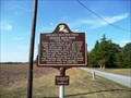
| Insley Mounds: Ancient Mounds Trail in Louisiana Historical Markers Marker on Frankie Loftin Road, 1.4 mi from Martin Road, off of La 17 South of Delhi posted by: kwashnak location: Louisiana date approved: 11/14/2010 last visited: never |
 view gallery view galleryE21.9 km |  Somerset Cemetery - Tensas Parish, Louisiana Somerset Cemetery - Tensas Parish, Louisiana
in Worldwide Cemeteries A small cemetery on Hwy 65 in Tensas Parish, Louisiana. It contains 8 graves posted by: lovorn location: Louisiana date approved: 01/10/2012 last visited: never |
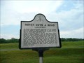 view gallery view galleryE22.5 km | Hovey Cuts a Road Marker in Louisiana Historical Markers Civil War Marker as parts of Grant's March through Louisiana located at US 65 and LA 898 (near LA 575) posted by: kwashnak location: Louisiana date approved: 08/11/2010 last visited: 10/10/2014 |
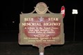
 view gallery view gallery W22.7 km W22.7 km
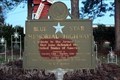
|  U.S. 425, Winnsboro, LA U.S. 425, Winnsboro, LA
in Blue Star Memorial Highway Markers A Blue Star Memorial Highway located on US 425 at Loop Rd, Winnsboro posted by:  Markerman62 Markerman62 location: Louisiana date approved: 12/23/2019 last visited: 12/23/2019 |
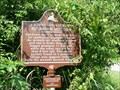
 view gallery view galleryE23 km | Balmoral Mounds: Ancient Mounds Trail in Louisiana Historical Markers Ancient Mounds Trail stop at on US 65, 4.3 miles north of LA 4 near Newellton posted by: kwashnak location: Louisiana date approved: 08/11/2010 last visited: 03/28/2017 |
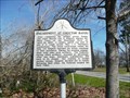
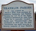 view gallery view galleryW23.2 km | Franklin Parish - Winnsboro, Louisiana in Louisiana Historical Markers A Louisian Historic Marker at the Franklin Parish Courthouse in Winnsboro, Louisiana posted by: lovorn location: Louisiana date approved: 01/10/2012 last visited: 06/17/2019 |
 view gallery view galleryW23.5 km |  Winnsboro, Louisiana - 71295 Winnsboro, Louisiana - 71295
in U.S. Post Offices A US Post Office in Winnsboro, Louisiana posted by: lovorn location: Louisiana date approved: 01/16/2012 last visited: 06/17/2019 |
 view gallery view galleryW23.5 km |  1936 - US Post Office - Winnsboro, Louisiana 1936 - US Post Office - Winnsboro, Louisiana
in Dated Buildings and Cornerstones A US Post Office in Winnsboro, Louisiana posted by: lovorn location: Louisiana date approved: 01/11/2012 last visited: 06/17/2019 |
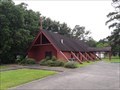 view gallery view galleryW24.3 km |  Former St. Columba's Episcopal Church - Winnsboro, LA, USA Former St. Columba's Episcopal Church - Winnsboro, LA, USA
in Anglican and Episcopal Churches Former Episcopal Church in the town of Winnsboro, Louisiana. Active from the late 1950s to 2020. posted by: irishtexas1885 location: Louisiana date approved: 06/18/2019 last visited: never |
 view gallery view gallery SE24.6 km SE24.6 km
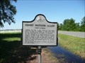
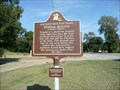
| Henry Watkins Allen in Louisiana Historical Markers Located in Tensas Parish on Louisiana 605, North of Cutoff Road in Newellton. posted by: kwashnak location: Louisiana date approved: 12/21/2011 last visited: never |
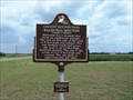
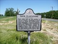
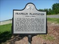 view gallery view gallerySE24.6 km | Franklin Plantation in Louisiana Historical Markers Located in Tensas Parish on Louisiana 605, North of Cutoff Road in Newellton. posted by: kwashnak location: Louisiana date approved: 12/21/2011 last visited: never |
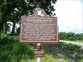
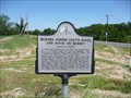 view gallery view galleryE25.4 km | Bridges Across Holt's Bayou and Bayou Du Rosset in Louisiana Historical Markers Located in Tensas Parish on Louisiana 605 at Louisiana 608, North of Newellton. posted by: kwashnak location: Louisiana date approved: 12/21/2011 last visited: never |
 view gallery view galleryE25.4 km | DavisPlantation in Louisiana Historical Markers Located in Tensas Parish on Louisiana 605 at Louisiana 608, North of Newellton. posted by: kwashnak location: Louisiana date approved: 12/21/2011 last visited: never |
 view gallery view galleryS26.7 km | Mayflower Mound: Ancient Mounds Trail in Louisiana Historical Markers Ancient Mounds Trail marker on LA Highway 892, 1.1 miles north of LA 3252 near St. Joseph posted by: kwashnak location: Louisiana date approved: 08/11/2010 last visited: never |
 view gallery view galleryN27.7 km | Tendal Mound: Ancient Mounds Trail in Louisiana Historical Markers Ancient Mound Trail - Located 11.8 miles West Tallulah on US 80. posted by: kwashnak location: Louisiana date approved: 09/23/2010 last visited: 09/18/2015 |
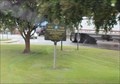
 view gallery view galleryN28.6 km |  MoPac 13497 -- Delhi LA MoPac 13497 -- Delhi LA
in Train Cabooses Old Missouri Pacific RR caboose 13497 is on permanent display at the old Delhi depot, which now serves as the Delhi visitor center. Apparently, this caboose started life on the Chicago and Eastern Illinois (C&EI) RR. posted by: Benchmark Blasterz location: Louisiana date approved: 09/22/2014 last visited: 09/24/2014 |
 view gallery view galleryN28.6 km | LA SH 17 N of US 80 to Epps -- Delhi LA in Blue Star Memorial Highway Markers Louisiana State Highway 17 from the US 80 north to Epps LA is a Blue star Memorial Highway. posted by: Benchmark Blasterz location: Louisiana date approved: 09/16/2014 last visited: 09/17/2014 |
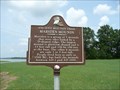
 view gallery view gallery SW29.3 km SW29.3 km
| U.S. 425, Wisner, LA in Blue Star Memorial Highway Markers A Blue Star Memorial Highway located at US 425 and Watson St, Misner posted by: Markerman62 location: Louisiana date approved: 12/23/2019 last visited: 12/23/2019 |
 view gallery view galleryS29.9 km | Sundown Mounds: Ancient Mounds Trail in Louisiana Historical Markers Ancient Mounds trail marker - Sundown Road, 2.2 miles from LA 892 posted by: kwashnak location: Louisiana date approved: 08/11/2010 last visited: never |
 view gallery view gallerySE31.1 km | Engagement at Choctaw Bayou in Louisiana Historical Markers Marker on LA 605 just south of 607 in Lake Bruin at Choctaw Bayou. posted by: kwashnak location: Louisiana date approved: 04/18/2012 last visited: never |
 view gallery view galleryN32 km | Marsden Mounds in Louisiana Historical Markers The Marsden Mounds are located in the Poverty Point Reservoir State Park, 0.3 miles from the entrance in a pull off on the right side of Poverty Point Parkway. Admission is charged to the park. posted by: kwashnak location: Louisiana date approved: 07/21/2011 last visited: never |
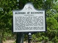 view gallery view gallery NE32 km NE32 km
| Skirmish at Richmond in Louisiana Historical Markers Richmond was a community outside of Tallulah, Louisiana which was destroyed during the Civil War. A pair of markers note the site and events. Hwy 603, Tallulah. 0.7 mi south of I20 underpass. posted by: kwashnak location: Louisiana date approved: 12/21/2011 last visited: 08/25/2019 |
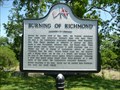 view gallery view galleryNE32 km | Burning of Richmond in Louisiana Historical Markers Richmond was a community outside of Tallulah, Louisiana which was destroyed during the Civil War. A pair of markers note the site and events. Hwy 603, Tallulah. 0.7 mi south of I20 underpass. posted by: kwashnak location: Louisiana date approved: 12/21/2011 last visited: 08/25/2019 |
|