 view gallery view gallery S9 km S9 km
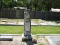
|   Andrew Johnson Rumer - Ramer Cemetery - Ramer, Alabama Andrew Johnson Rumer - Ramer Cemetery - Ramer, Alabama
in Woodmen of the World Grave Markers/Monuments Andrew Johnson Rumer was born on September 6, 1869 and died on May 26, 1916. posted by:  xptwo xptwo location: Alabama date approved: 06/20/2012 last visited: never |
 view gallery view galleryS9 km | Charles R. Long - Ramer Cemetery - Ramer, Alabama in Woodmen of the World Grave Markers/Monuments Charles R. Long was born on August 10, 1865 and died on May 16, 1910. posted by: xptwo location: Alabama date approved: 06/22/2012 last visited: never |
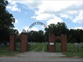
 view gallery view galleryS9.2 km |  Ramer Cemetery Arch - Ramer, Alabama Ramer Cemetery Arch - Ramer, Alabama
in Freestanding Arches This arch leads into the Ramer Cemetery in the unincorporated community of Ramer, Alabama. posted by: xptwo location: Alabama date approved: 06/28/2012 last visited: never |
 view gallery view galleryS9.2 km |  Ramer Cemetery - Ramer, Alabama Ramer Cemetery - Ramer, Alabama
in Worldwide Cemeteries Ramer Cemetery is located in the unincorporated community of Ramer, Alabama, which is in the south part of Montgomery County. posted by: xptwo location: Alabama date approved: 07/27/2012 last visited: never |
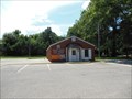
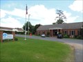 view gallery view galleryS9.2 km |  Ramer Branch Library - Ramer, Alabama Ramer Branch Library - Ramer, Alabama
in Wi-Fi Hotspots The Ramer Branch is part of the Montgomery City - County Library System. It serves the community of Ramer. posted by: xptwo location: Alabama date approved: 06/27/2012 last visited: never |
 view gallery view galleryS9.2 km |  Ramer Branch Library - Ramer, Alabama Ramer Branch Library - Ramer, Alabama
in Libraries The Ramer Branch is part of the Montgomery City - County Library System. It serves the community of Ramer. posted by: xptwo location: Alabama date approved: 06/27/2012 last visited: never |
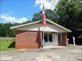 view gallery view galleryS9.5 km |  Ramer, AL - 36069 Ramer, AL - 36069
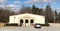
in U.S. Post Offices Ramer is a small community located in the southern part of Montgomery County, Alabama. posted by: xptwo location: Alabama date approved: 10/18/2012 last visited: never |
 view gallery view gallery NW11.1 km NW11.1 km
|  RAMM Field - Montgomery, Alabama RAMM Field - Montgomery, Alabama
in Model Aircraft Fields The Radio Aero Modelers Of Montgomery (RAMM) Field is located about five miles south of Montgomery, Alabama. posted by: xptwo location: Alabama date approved: 07/12/2012 last visited: never |
 view gallery view gallery W12.6 km W12.6 km
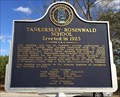
|  Tankersley Rosenwald School - Hope Hull, AL Tankersley Rosenwald School - Hope Hull, AL
in Alabama Historical Markers One of many rural schools built in the early 20th century for African American students in Alabama. posted by:  hoteltwo hoteltwo location: Alabama date approved: 01/21/2014 last visited: 07/25/2022 |
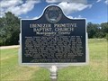 view gallery view galleryS13.2 km | Ebenezer Primitive Baptist Church - Montgomery County - Ramer, AL in Alabama Historical Markers Located at Naftel Ramer Road and Smiley Ferry Road, Ramer posted by: Markerman62 location: Alabama date approved: 08/12/2022 last visited: never |
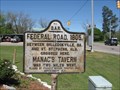 view gallery view galleryW14.3 km | Federal Road, 1805 - Hope Hull, AL in Alabama Historical Markers This marker indicating the route of the Federal Road was placed by the DAR in 1933. posted by: xptwo location: Alabama date approved: 03/04/2013 last visited: 07/25/2022 |
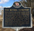 view gallery view galleryNW14.3 km | The Bethel Cemetery - Pintlala, AL in Alabama Historical Markers Located along US 31, just north of County Road 24 (Federal Road), this historic cemetery had a difficult break in the church supporting it. posted by: hoteltwo location: Alabama date approved: 01/21/2014 last visited: never |
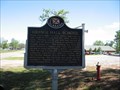 view gallery view galleryW14.5 km | Grange Hall School - Hope Hull, Alabama in Alabama Historical Markers Marker giving the history of the school that used the old Grange Hall in Pintlala for several decades. posted by: xptwo location: Alabama date approved: 03/27/2012 last visited: 07/25/2022 |
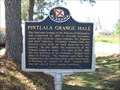 view gallery view galleryW14.5 km | Pintlala Grange Hall - Hope Hull, Alabama in Alabama Historical Markers The marker gives the history of the Grange Hall in the small community of Pintlala, Alabama. posted by: xptwo location: Alabama date approved: 03/31/2012 last visited: 07/25/2022 |
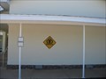 view gallery view galleryW14.6 km |  Safe Place - Pintlala, Alabama Safe Place - Pintlala, Alabama
in Safe Place Havens This safe place is located at Pintlala School, located on County Highway 24 (215 Federal Road, Hope Hull, AL 36043). posted by: xptwo location: Alabama date approved: 03/25/2012 last visited: never |
 view gallery view galleryW14.6 km | Pintlala School - Hope Hull, Alabama in Alabama Historical Markers Marker giving the history of Pintlala School in Hope Hull, Alabama. posted by: xptwo location: Alabama date approved: 03/26/2012 last visited: 07/25/2022 |
 view gallery view galleryW14.8 km | Pintlala Branch Library - Hope Hull, Alabama in Libraries The Pintlala Branch is part of the Montgomery City - County Library System. It serves the community of Pintlala. posted by: xptwo location: Alabama date approved: 03/25/2012 last visited: never |
 view gallery view galleryW14.8 km | Pintlala Branch Library - Hope Hull, Alabama in Wi-Fi Hotspots The Pintlala Branch is part of the Montgomery City - County Library System. It serves the community of Pintlala. Wi-fi is available for patrons. posted by: xptwo location: Alabama date approved: 03/25/2012 last visited: never |
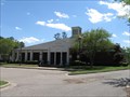
 view gallery view galleryW14.8 km |  Pintlala Volunteer Fire Department - Pintlala, AL Pintlala Volunteer Fire Department - Pintlala, AL
in Firehouses Well equipped volunteer fire department with new facilities near the intersection of U.S. Highway 31 and County Road 24. posted by: hoteltwo location: Alabama date approved: 01/30/2014 last visited: never |
 view gallery view gallery NE15 km NE15 km
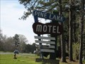
|  Pine Lake Motel - Pike Road, AL REMOVED 2013 Pine Lake Motel - Pike Road, AL REMOVED 2013
in Artistic Neon Lights This artistic Googie sign has the look and feel of the 1950s when the motel opened. NOTE: The sign was replaced in 2013 by new owners, but the waymark is being kept for historical purposes. posted by: xptwo location: Alabama date approved: 01/23/2013 last visited: 09/10/2013 |
 view gallery view galleryNE15 km |  Pine Lake Motel - Pike Road, AL REMOVED 2013 Pine Lake Motel - Pike Road, AL REMOVED 2013
in Googie Architecture he Pine Lake Motel sign looks like it was built in the 1950s when the motel opened. NOTE: The sign was replaced in 2013 by new owners, but the waymark is being kept for historical purposes. posted by: xptwo location: Alabama date approved: 03/17/2012 last visited: 09/10/2013 |
 view gallery view galleryNE15 km | Pine Lake Motel - Pike Road, AL REMOVED 2013 in Neon Signs The Pine Lake Motel sign looks like it was built in the 1950s when the motel opened. NOTE: The sign was replaced in 2013 by new owners, but the waymark is being kept for historical purposes. posted by: xptwo location: Alabama date approved: 03/15/2012 last visited: 09/10/2013 |
 view gallery view gallery SW15.3 km SW15.3 km
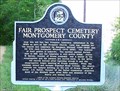
| Fair Prospect Cemetery Montgomery County - Highland Home, AL in Alabama Historical Markers Historical marker at near a historical cemetery. posted by: hummerstation location: Alabama date approved: 04/22/2012 last visited: 07/25/2022 |
 view gallery view galleryS15.9 km | Grady, AL - 36036 in U.S. Post Offices Grady is a small community in the south part of Montgomery County, Alabama. posted by: xptwo location: Alabama date approved: 08/15/2012 last visited: never |
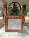 view gallery view gallerySW16.1 km |  Lamar Memorial Bell - Mount Carmel UMC - Mt. Carmel, AL Lamar Memorial Bell - Mount Carmel UMC - Mt. Carmel, AL
in Bells Located in a separate structure next to the Mt. Carmel UMC church in Mt. Carmel, AL, this bell originally was located in a UMC church in Letohatchee, AL. posted by: hoteltwo location: Alabama date approved: 01/02/2014 last visited: never |
|