 view gallery view gallery SE4 km SE4 km
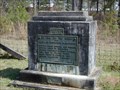
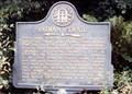
|   Battle of Shephards Plantation-WPA-Stewart Co Battle of Shephards Plantation-WPA-Stewart Co
in Georgia Historical Markers Located on Ga 39 just north of Florence Marina State Park posted by:  Sprinterman Sprinterman location: Georgia date approved: 11/26/2010 last visited: 06/29/2022 |
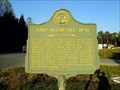
 view gallery view gallerySE4 km |  Shepherd's Plantation Shepherd's Plantation
in Non-Specific Veteran Memorials One of the worst defeats of the Georgia militia during the (not well known) Indian War of 1836. posted by: stsimpson location: Georgia date approved: 02/04/2007 last visited: 06/25/2010 |
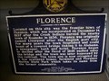 view gallery view gallerySE5.1 km | Florence-HCC-Stewart Co in Georgia Historical Markers Located INSIDE the interpretive center at Florence Marina State Park. posted by: Sprinterman location: Georgia date approved: 11/04/2010 last visited: 03/07/2006 |
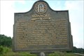
 view gallery view gallery E5.8 km E5.8 km
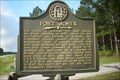
| Fort McCreary-1836-GHM 128-7-Stewart Co in Georgia Historical Markers At Omaha on Ga 39 posted by: Sprinterman location: Georgia date approved: 10/25/2010 last visited: 12/01/2006 |
 view gallery view gallerySE8.2 km | FORT JONES - GHM 129-9 - Stewart County., Ga. in Georgia Historical Markers Located on Ga 39 about 2 miles south of Florence posted by:  Coinseekers Coinseekers location: Georgia date approved: 05/19/2010 last visited: 12/01/2006 |
 view gallery view galleryE9.3 km | Indian Trail GHM 128-3 in Georgia Historical Markers Located on GA 39 east of Omaha. posted by: Markerman62 location: Georgia date approved: 11/05/2015 last visited: 11/08/2015 |
 view gallery view gallery S10 km S10 km
| Roanoke - GHC 128-10 - Stewart County.,Ga. in Georgia Historical Markers Located at Ga 39 about 2 1/2 miles south of Florence posted by: Coinseekers location: Georgia date approved: 05/20/2010 last visited: 12/01/2006 |
 view gallery view gallery W10 km W10 km
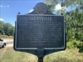
|  Glennville - Glennville, AL Glennville - Glennville, AL
in Alabama Historical Markers Located on Old Seale Highway north of Penny Well Road, Glennville posted by: Markerman62 location: Alabama date approved: 07/07/2022 last visited: never |
 view gallery view gallery NE12.2 km NE12.2 km
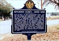
| Spanish Fort, 1689-1691 in Alabama Historical Markers On AL 165 at Terminal Rd in Holy Trinity. posted by: Markerman62 location: Alabama date approved: 03/26/2015 last visited: 03/29/2015 |
 view gallery view gallery N15.9 km N15.9 km
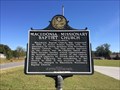
| Macedonia Missionary Baptist Church /Macedonia School - Seale, AL in Alabama Historical Markers Marker located about 8 miles east of Seale on CR 18 notes the beginnings of the Baptist Church and one room schoolhouse. posted by: hoteltwo location: Alabama date approved: 10/24/2014 last visited: 01/08/2022 |
 view gallery view galleryE16.4 km | Providence United Methodist Church-HCC-Stewart Co in Georgia Historical Markers At church, 7 mi W of Lumpkin on Ga 39 Connector posted by: Sprinterman location: Georgia date approved: 11/04/2010 last visited: 10/25/2020 |
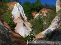 view gallery view galleryE16.7 km |  Providence Canyon State Park (Little Grand Canyon) - Lumpkin, GA Providence Canyon State Park (Little Grand Canyon) - Lumpkin, GA
in State/Provincial Parks Providence Canyon State Park is a 1,001 acre park located in west central Georgia. The park contains Providence Canyon, which is sometimes called Georgia's "Little Grand Canyon". It is considered to be one of the Seven Natural Wonders of Georgia. posted by: ArmyFamily4 location: Georgia date approved: 03/31/2011 last visited: 10/25/2020 |
 view gallery view gallerySE17.1 km | Rev. David Walker Lowe-Stewart Co in Georgia Historical Markers Just inside entrance, Providence Canyon State Park, Ga 39 Connector posted by: Sprinterman location: Georgia date approved: 11/04/2010 last visited: 10/25/2020 |
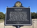 view gallery view gallery NW17.2 km NW17.2 km
| Villula - Pittsview, AL in Alabama Historical Markers Marker located in front of Villula Methodist Church Cemetery along U.S. Highway 431 but well off the road. Nicely maintained cemetery. posted by: hoteltwo location: Alabama date approved: 10/24/2014 last visited: 01/08/2022 |
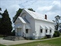 view gallery view galleryN18 km |  Oswichee Baptist Church - Oswichee, AL Oswichee Baptist Church - Oswichee, AL
in Baptist Churches The lovely little Oswichee Baptist Church in Oswichee, Alabama, USA, was constructed in 1882, the same year its congregration was established. posted by: Marine Biologist location: Alabama date approved: 05/17/2009 last visited: 05/16/2009 |
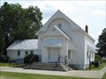 view gallery view galleryN18 km |  Oswichee Baptist Church - Oswichee, AL Oswichee Baptist Church - Oswichee, AL
in This Old Church The lovely little Oswichee Baptist Church in Oswichee, Alabama, USA, was constructed in 1882, the same year its congregration was established. posted by: Marine Biologist location: Alabama date approved: 05/17/2009 last visited: 05/16/2009 |
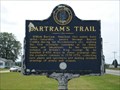
 view gallery view galleryN18 km |  Bartram's Trail - Oswichee, Alabama, USA Bartram's Trail - Oswichee, Alabama, USA
in UK Historical Markers This Bartram's Trail marker is located off of Highway 165 near the Oswichee Baptist Church in Oswichee, Russell County, Alabama. posted by: Marine Biologist location: Alabama date approved: 10/10/2010 last visited: 07/03/2004 |
 view gallery view galleryN18 km |  Bartram's Trail - Oswichee, AL Bartram's Trail - Oswichee, AL
in Spirit of '76 This Bicentennial marker about Bartram's Trail is located off of Highway 165 near the Oswichee Baptist Church in Oswichee, Russell County, Alabama. posted by: Marine Biologist location: Alabama date approved: 10/09/2010 last visited: 07/03/2004 |
 view gallery view galleryN18 km |  Bartram's Trail - Oswichee, AL Bartram's Trail - Oswichee, AL
in Bartram Trail Historical Markers This Bartram's Trail marker is located off of Highway 165 near the Oswichee Baptist Church in Oswichee, Russell County, Alabama.
posted by: Marine Biologist location: Alabama date approved: 05/17/2009 last visited: 07/03/2004 |
 view gallery view galleryN18 km | Bartram's Trail - Oswichee, AL in Alabama Historical Markers This Bartram's Trail marker is located off of Highway 165 near the Oswichee Baptist Church in Oswichee, Russell County, Alabama. posted by: Marine Biologist location: Alabama date approved: 05/21/2009 last visited: 08/16/2019 |
 view gallery view galleryNW19.5 km | William Bacon Oliver 1867-1948 - Seale, AL in Alabama Historical Markers Located off US 431 south of Old Seale Highway, Seale posted by: Markerman62 location: Alabama date approved: 03/21/2022 last visited: never |
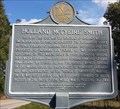 view gallery view galleryNW20.8 km | Holland McTyeire Smith - Seale, AL in Alabama Historical Markers Marker provides a short bio on the military life of General Holland McTyeire Smith. posted by: hoteltwo location: Alabama date approved: 10/17/2013 last visited: 01/08/2022 |
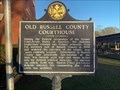 view gallery view galleryNW21.1 km | Old Russell County Courthouse/Russell County Courthouse - Seale, Alabama in Alabama Historical Markers Located in front of the building at Jackson Street and Longview Street, Seale posted by: Markerman62 location: Alabama date approved: 03/21/2022 last visited: never |
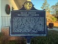 view gallery view galleryNW21.2 km | Seale United Methodist Church - Seale, AL in Alabama Historical Markers Located at Courthouse Street and Chapel Street, Seale posted by: Markerman62 location: Alabama date approved: 03/21/2022 last visited: never |
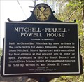 view gallery view galleryNW21.4 km | Mitchell-Ferrell-Powell House - Seale, AL in Alabama Historical Markers Marker shows the history of the Mitchell-Ferrell-Powell House, on Jackson Street, in Seale, AL. posted by: hoteltwo location: Alabama date approved: 10/17/2013 last visited: 01/08/2022 |
|