 view gallery view gallery NW10.3 km NW10.3 km
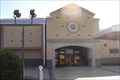
|   Mount Carmel Church - Pleasant, AL Mount Carmel Church - Pleasant, AL
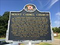
in Alabama Historical Markers Marker describes to beginnings of the Mount Carmel Church and the later changes its name and use. Located on Dallas County Road 12. posted by:  hoteltwo hoteltwo location: Alabama date approved: 08/04/2014 last visited: 05/07/2013 |
 view gallery view gallery E13.4 km E13.4 km
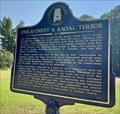
| Enslavement & Racial Terror - Mt Willing, AL in Alabama Historical Markers Located along AL-21 at Snow Hill Drive, this marker describes the devastating violence that once took place in Alabama. More than 350 African-Americans were lynched in Alabama in 66 years of which 16 were killed in this county. posted by: hoteltwo location: Alabama date approved: 09/16/2020 last visited: never |
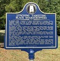 view gallery view galleryE13.4 km | Lynching Targeting Black Sharecroppers - Mt Willing, AL in Alabama Historical Markers Marker memorializes the lynchings of Mr. Ed Bracy, Mr. Jim Press Meriweather, and Rev. G. Smith Watkins, three Black sharecroppers and union leaders lynched in Lowndes County in 1935. Marker is located near Mt Willing Church on AL-21. posted by: hoteltwo location: Alabama date approved: 09/16/2020 last visited: never |
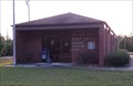
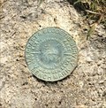 view gallery view galleryE13.4 km |  USCGS Benchmark CN0878 - Mt Willing, AL USCGS Benchmark CN0878 - Mt Willing, AL
in U.S. Benchmarks This bench mark is located next to the former Snow Hill Christian Church Annex on AL-21 at Snow Hill Dr. It is in excellent condition. posted by: hoteltwo location: Alabama date approved: 08/12/2020 last visited: never |
 view gallery view gallery SW15.8 km SW15.8 km
|  Furman, Alabama 36741 Furman, Alabama 36741
in U.S. Post Offices Furman, also known as Old Snow Hill, is an unincorporated community in Wilcox County, Alabama. posted by: hoteltwo location: Alabama date approved: 08/28/2013 last visited: never |
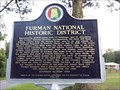 view gallery view gallerySW15.8 km | Furman National Historic District - Furman, AL in Alabama Historical Markers Marker providing the history of the settling of Furman, Alabama, its historic district, and notable citizens. posted by: hoteltwo location: Alabama date approved: 08/28/2013 last visited: never |
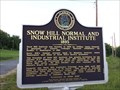 view gallery view gallerySW20.1 km | Snow Hill Normal and Industrial Institute 1893 - Snow Hill, AL in Alabama Historical Markers History of the founding of the Snow Hill Institute educational institution for African Americans in Alabama’s Black Belt. posted by: hoteltwo location: Alabama date approved: 08/28/2013 last visited: never |
 view gallery view gallery NE21.7 km NE21.7 km
|  "The Black Panther Party's deep Alabama roots" -- Mt. Gillard Baptist Church, Lowndes Co. AL "The Black Panther Party's deep Alabama roots" -- Mt. Gillard Baptist Church, Lowndes Co. AL
in News Article Locations Located along the route of the historic Selma-Montgomery Voting Rights march, Mount Gillard is known as the "Mother Church of the Civil Rights Movement" in Lowndes County AL, where the Black Panther Party got its start. posted by:  Benchmark Blasterz Benchmark Blasterz location: Alabama date approved: 09/06/2017 last visited: 07/26/2017 |
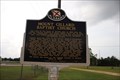 view gallery view galleryNE21.7 km | Mount Gillard Baptist Church -- Tyler AL in Alabama Historical Markers The Alabama state historic marker in front of Mount Gillard Baptist Church in Tyler AL posted by: Benchmark Blasterz location: Alabama date approved: 09/07/2017 last visited: 07/28/2017 |
 view gallery view galleryNE21.7 km |  Mt. Gillard Baptist Church -- Lowndes Co. AL Mt. Gillard Baptist Church -- Lowndes Co. AL
in National Scenic Byways The Mount Gillard Baptist Church in Tyler AL, along the Selma to Montgomery March Scenic Byway posted by: Benchmark Blasterz location: Alabama date approved: 09/10/2017 last visited: 07/29/2017 |
 view gallery view galleryNE21.7 km |  Mt. Gillard Baptist Church - Lowndes Co., AL Mt. Gillard Baptist Church - Lowndes Co., AL
in Baptist Churches Mount Gillard Baptist Church in Tyler AL posted by: Benchmark Blasterz location: Alabama date approved: 09/01/2017 last visited: 07/27/2017 |
 view gallery view galleryNE22 km |  YAH 24 miles from Selma, 29 miles to Montgomery -- Lowndes Interpretive Center, Selma-Montgomery NHT, Lowndes Co. AL YAH 24 miles from Selma, 29 miles to Montgomery -- Lowndes Interpretive Center, Selma-Montgomery NHT, Lowndes Co. AL
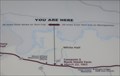
in 'You Are Here' Maps The larger You Are Here map at the Lowndes Interpretive Center along the Selma-Montgomery NHT, in Lowndes Co. AL posted by: Benchmark Blasterz location: Alabama date approved: 09/01/2017 last visited: 07/27/2017 |
 view gallery view galleryNE22 km | You are Here-Lowndes County Interpretive Center, Whitehall AL in 'You Are Here' Maps This is the You Are Here sign at the Lowndes Interpretive Center in Whitehall AL. posted by: OHail location: Alabama date approved: 12/14/2011 last visited: 07/27/2017 |
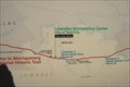
 view gallery view galleryNE22 km | Selma to Montgomery March Byway-Lowndes County Interpretive Center in National Scenic Byways The Lowndes County Interpretive Center is about half way along the 54-mile stretch of highway of the 1965 Selma to Montgomery March. posted by: OHail location: Alabama date approved: 12/14/2011 last visited: 07/01/2023 |
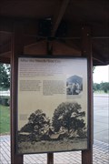 view gallery view galleryNE22 km |  "After the March -- Tent City" -- Lowndes Interpretive Center, Lowndes Co. AL "After the March -- Tent City" -- Lowndes Interpretive Center, Lowndes Co. AL
in Signs of History The sign of history outside of the Lowndes County interpretive center explains what happened after the end of the Selma to Montgomery Voting Rights march posted by: Benchmark Blasterz location: Alabama date approved: 09/02/2017 last visited: 01/17/2022 |
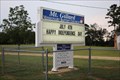
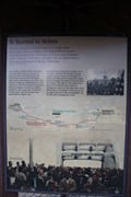 view gallery view galleryNE22 km | "It started in Selma" -- Lowndes Interpretive Center, Lowndes Co. AL in Signs of History The sign of history outside of the Lowndes County Interpretive Center explains he genesis of the Selma to Montgomery Voting Rights March posted by: Benchmark Blasterz location: Alabama date approved: 09/02/2017 last visited: 01/17/2022 |
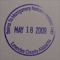 view gallery view galleryNE22 km |  Selma to Montgomery NHT - Lowndes County AL Selma to Montgomery NHT - Lowndes County AL
in NPS Passport Cancellation Stations The stamp is located at the visitor center located in White Hall, AL on US 80. This is the location of Tent City. posted by: nomadwillie location: Alabama date approved: 07/09/2009 last visited: 07/27/2017 |
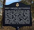 view gallery view galleryNE22.2 km | Holy Ground Battlefield - White Hall, AL in Alabama Historical Markers Marker providing a short history of an Indian battle near the Alabama River. The movement, started by the Prophet Josiah Francis, and his Red Sticks were nearly annihilated. posted by: hoteltwo location: Alabama date approved: 12/27/2013 last visited: never |
 view gallery view gallery S23.5 km S23.5 km
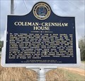
| Coleman-Crenshaw House - Greenville, AL in Alabama Historical Markers Marker located near the Mt. Olive Missionary Baptist Church, on Ridge Road at Crenshaw Road, describes one of the counties pioneer families and home. posted by: hoteltwo location: Alabama date approved: 02/17/2019 last visited: never |
 view gallery view galleryE26.1 km | Varner's Cash Store - Hayneville, AL in Alabama Historical Markers Marker describes the shooting death of a young civil rights activist in Hayneville, AL during the Civil Rights Movement of the 1960s. The murderer was a shotgun-wielding special county deputy who was acquitted by an all-white jury. posted by: hoteltwo location: Alabama date approved: 04/15/2020 last visited: never |
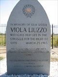
 view gallery view galleryNE26.1 km | Viola Liuzzo Memorial - Lowndes County, Alabama in National Scenic Byways The Viola Liuzzo Memorial along US Highway 80 (mile marker 111) marks the place where the civil rights worker was shot and killed. posted by: xptwo location: Alabama date approved: 01/06/2012 last visited: 07/26/2017 |
 view gallery view galleryNE26.1 km |  Viola Liuzzo Memorial - Lowndes County, Alabama Viola Liuzzo Memorial - Lowndes County, Alabama
in Citizen Memorials The Viola Liuzzo Memorial along US Highway 80 (mile marker 111) marks the place where the civil rights worker was shot and killed. posted by: xptwo location: Alabama date approved: 03/29/2012 last visited: 07/26/2017 |
 view gallery view galleryNE26.1 km |  Viola Liuzzo Memorial Viola Liuzzo Memorial
in Civil Rights Memorials The Viola Liuzzo Memorial along US Highway 80 (mile marker 111) marks the place where the civil rights worker was shot and killed. posted by: xptwo location: Alabama date approved: 10/16/2011 last visited: 07/26/2017 |
 view gallery view galleryNE26.1 km |  Viola Liuzzo Murder Site -- Lowndes Co. AL Viola Liuzzo Murder Site -- Lowndes Co. AL
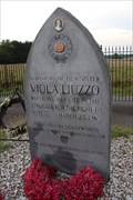
in Infamous Crime Scenes A memorial at the spot where Viola Liuzzo, who was transporting local civil rights activists back to Selma, was shot and killed by the Ku Klux Klan posted by: Benchmark Blasterz location: Alabama date approved: 08/25/2017 last visited: 07/26/2017 |
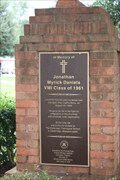 view gallery view galleryE26.1 km | Johnathan M. Daniels Memorial -- Hayneville AL in Civil Rights Memorials A memorial to Johnathan M. Daniels, a white Episcopal Seminarian and civil rights worker murdered here on 20 Aug 1965 for his efforts registering blacks to vote and integrating public spaces in Lowndes County. posted by: Benchmark Blasterz location: Alabama date approved: 08/25/2017 last visited: 07/26/2017 |
|