 view gallery view gallery W19.5 km W19.5 km
|   Quijotoa Quijotoa
in Arizona Historical Markers This is a Papago word meaning, mountain shaped like a carrying basket. posted by:  leadhiker leadhiker location: Arizona date approved: 05/17/2010 last visited: 03/12/2011 |
 view gallery view gallery SE31.1 km SE31.1 km
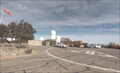
|  Kitt Peak Helipad Kitt Peak Helipad
in Helicopter Landing Pads The Helipad at Kitt Peak National Observatory posted by:  TucsonThompsen TucsonThompsen location: Arizona date approved: 06/04/2010 last visited: 09/08/2019 |
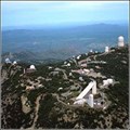 view gallery view gallerySE31.2 km |  Kitt Peak National Observatory (Tucson, Arizona) Kitt Peak National Observatory (Tucson, Arizona)
in Astronomical Observatories Kitt Peak National Observatory (KPNO), part of the National Optical Astronomy Observatory (NOAO), supports the most diverse collection of astronomical observatories on Earth for nighttime optical and infrared astronomy and daytime study of the Sun. posted by: CPT Kelly & MAJ Sandy location: Arizona date approved: 03/27/2006 last visited: 06/20/2021 |
 view gallery view gallerySE31.2 km |  Sun Clock at Kitt Peak National Observatory, Arizona 386, Sells, AZ 85634 Sun Clock at Kitt Peak National Observatory, Arizona 386, Sells, AZ 85634
in Sundials The polished sphere of Jacobs' sun clock. posted by: thearizonaguy location: Arizona date approved: 05/29/2015 last visited: 10/15/2015 |
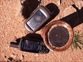
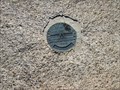
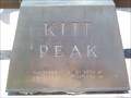 view gallery view gallerySE31.2 km |  Kitt Peak National Observatory - 31° 57' 30.32" N 7h 26 m 22.72" W Kitt Peak National Observatory - 31° 57' 30.32" N 7h 26 m 22.72" W
in Permanent Geographic Coordinates A block engraved on the sundial at the Kitt Peak National Observatory posted by: TucsonThompsen location: Arizona date approved: 06/03/2010 last visited: 07/26/2021 |
 view gallery view gallery NE49.2 km NE49.2 km
|  Silver Bell Windmill - Silver Bell, AZ Silver Bell Windmill - Silver Bell, AZ
in Windmills This working windmill is on a small ranch northwest of Tucson, Arizona. posted by: rjmcdonough1 location: Arizona date approved: 02/24/2018 last visited: never |
 view gallery view galleryNE50.9 km |  Silver Bell Cemetery - Pima County, AZ Silver Bell Cemetery - Pima County, AZ
in Abandoned Cemeteries This cemetery served the ghost town of Silver Bell, northwest of Tucson, Arizona. posted by: rjmcdonough1 location: Arizona date approved: 02/25/2018 last visited: 02/25/2018 |
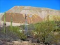
 view gallery view galleryNE51 km |  ASARCO Grupo Mexico Mine - Silver Bell, AZ ASARCO Grupo Mexico Mine - Silver Bell, AZ
in Mines This is an open pit copper mine northwest of Tucson, Arizona. posted by: rjmcdonough1 location: Arizona date approved: 03/01/2018 last visited: never |
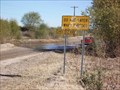
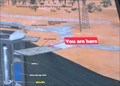 view gallery view galleryNE52.1 km |  Titan II Missile Silo - You Are Here - Marana, AZ Titan II Missile Silo - You Are Here - Marana, AZ
in 'You Are Here' Maps This sign helps orient visitors to their location on the former Titan Missile Silo site. posted by: rjmcdonough1 location: Arizona date approved: 03/01/2018 last visited: 04/22/2020 |
 view gallery view galleryNE52.1 km |  Titan II: A Proud Place in History - Ironwood National Monument, AZ Titan II: A Proud Place in History - Ironwood National Monument, AZ
in Signs of History This sign is one of a group describing the role of the Titan II missile and the silo located here. posted by: rjmcdonough1 location: Arizona date approved: 03/01/2018 last visited: 04/22/2020 |
 view gallery view gallery E53.8 km E53.8 km
|  Buckelew Farms - Corn Maze - Tucson, AZ Buckelew Farms - Corn Maze - Tucson, AZ
in Outdoor Mazes Buckelew Farms is a local farm that adds to the Halloween fun with it's infamous corn maze. Every year it's a newly designed shape. posted by: Poehunters location: Arizona date approved: 07/02/2013 last visited: 10/17/2015 |
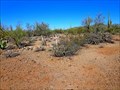
 view gallery view galleryE55.8 km |  Desert Tortoise Crossing, Pima County, AZ Desert Tortoise Crossing, Pima County, AZ
in Turtle Crossings Turtle sightings near a geocache in Southern Arizona. posted by: tugies location: Arizona date approved: 08/02/2014 last visited: 06/18/2021 |
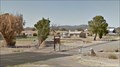
 view gallery view galleryNE58.9 km |  Santa Cruz River Crossing, Pinal County, Arizona Santa Cruz River Crossing, Pinal County, Arizona
in Bridgeless Water Crossings A perennial shallow river crossing in Pinal County Arizona. posted by: tugies location: Arizona date approved: 01/08/2015 last visited: 03/09/2015 |
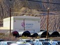
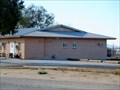
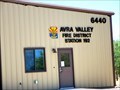 view gallery view galleryNE60.7 km |  Avra Valley Fire District Station 192 Avra Valley Fire District Station 192
in Firehouses Avra Valley is a rural area northwest of Tucson, Arizona. posted by: rjmcdonough1 location: Arizona date approved: 07/02/2020 last visited: never |
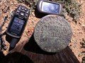
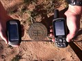
 view gallery view galleryE61.8 km |  LS4080 1/4 LS4080 1/4
in U.S. Benchmarks LS4080 1/4 posted by: philbeer location: Arizona date approved: 06/04/2012 last visited: 06/06/2012 |
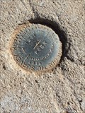 view gallery view galleryNE62.1 km | U.S.C.&G.S. X294 (CZ0652), Pima County, Arizona in U.S. Benchmarks A benchmark near N Pump Station Road, Pima County, Arizona posted by: T2D location: Arizona date approved: 12/28/2021 last visited: never |
 view gallery view galleryNE64.2 km |  Avra Valley Community Church - Marana, AZ Avra Valley Community Church - Marana, AZ
in Religious Buildings Multifarious The Avra Valley Community Church is located on a busy intersection is a rural part of Marana. posted by: rjmcdonough1 location: Arizona date approved: 02/21/2018 last visited: 04/28/2020 |
 view gallery view galleryE64.9 km | T16SR11E in U.S. Benchmarks U.S. General Land Office Survey - 1915. T16SR11ESWCOR Benchmark SW corner of Indian Reservation.
S28-S27
S33-S34 posted by: philbeer location: Arizona date approved: 06/04/2012 last visited: 06/06/2012 |
 view gallery view galleryE66.9 km | United States Army C.O.E. Disk E of Gunsight Mtn., Tucson, AZ in U.S. Benchmarks This is a bench mark type disk but has no data. posted by: sunspider location: Arizona date approved: 01/05/2014 last visited: never |
 view gallery view galleryNE67.3 km |  Sasco - Pima County, AZ Sasco - Pima County, AZ
in Ghost Towns Sasco was a mining town located northwest of Tucson, Arizona. posted by: rjmcdonough1 location: Arizona date approved: 02/26/2018 last visited: never |
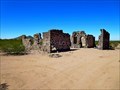 view gallery view galleryNE67.3 km |  Sasco, AZ Sasco, AZ
in Wikipedia Entries Sasco was a mining town located northwest of Tucson, Arizona. posted by: rjmcdonough1 location: Arizona date approved: 02/24/2018 last visited: never |
 view gallery view galleryNE67.3 km |  Hotel Rockland - Sasco, AZ Hotel Rockland - Sasco, AZ
in Photos Then and Now Hotel Rockland, located in the ghost town of Sasco, was abandoned, along with the town in 1921. posted by: rjmcdonough1 location: Arizona date approved: 03/04/2018 last visited: never |
 view gallery view galleryE67.8 km | T15SR11E in U.S. Benchmarks US General Land Office Survey 1915 , T15SR11E S28-S24/S25-26, P1R posted by: philbeer location: Arizona date approved: 06/04/2012 last visited: 06/06/2012 |
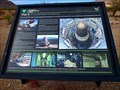
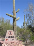 view gallery view galleryE67.9 km |  Saguaro National Park Nature Trail - Arizona Saguaro National Park Nature Trail - Arizona
in Self Guided Walks and Trails Informational markers along this paved, easy self-guided trail give the visitor an excellent overview of life in this Arizona desert. posted by: fishingwishing location: Arizona date approved: 04/10/2009 last visited: 05/25/2017 |
 view gallery view galleryNE67.9 km |  Sasco Cemetery - Red Rock, AZ Sasco Cemetery - Red Rock, AZ
in Worldwide Cemeteries The Sasco cemetery began as the burial ground for a mining town northwest of Tucson, Arizona. posted by: rjmcdonough1 location: Arizona date approved: 02/24/2018 last visited: 03/09/2018 |
|