 view gallery view gallery SW19.6 km SW19.6 km
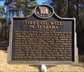
|   First Oil Well In Alabama - Gilbertown, AL First Oil Well In Alabama - Gilbertown, AL
in Alabama Historical Markers Located 2 miles west of Gilbertown on Paragon Rd, marker notes the beginnings of the oil industry in Alabama by H.L. Hunt of Texas. posted by:  hoteltwo hoteltwo location: Alabama date approved: 02/08/2015 last visited: 01/15/2018 |
 view gallery view gallery SE34 km SE34 km
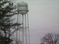
|  Coffeeville, AL WT Coffeeville, AL WT
in Water Towers Municipal Water Tower for Coffeeville, AL posted by:  Six Little Spookies Six Little Spookies location: Alabama date approved: 01/20/2008 last visited: never |
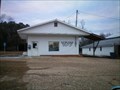
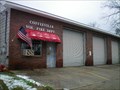 view gallery view gallerySE34 km |  Coffeevillle Vol Fire Dept Coffeevillle Vol Fire Dept
in Firehouses Firehouse for the volunteer firefighters of Coffeeville, Al. posted by: Six Little Spookies location: Alabama date approved: 01/31/2008 last visited: never |
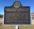 view gallery view gallerySE34.3 km | Clarke-Washington Electric Membership Corporation - Coffeeville, AL in Alabama Historical Markers Located at the intersection of U.S. 84 and River Street, marker notes the history of bringing electric power to the black belt counties of Clarke and Washington. posted by: hoteltwo location: Alabama date approved: 02/08/2015 last visited: 08/27/2019 |
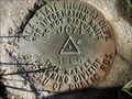 view gallery view gallerySE34.4 km |  Ala. State Hwy. Dept. JC71 1964 Ala. State Hwy. Dept. JC71 1964
in U.S. Benchmarks Alabama State Highway Department benchmark in Coffeeville, Clarke County, Alabama posted by: jkselby location: Alabama date approved: 01/15/2008 last visited: never |
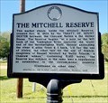 view gallery view gallerySE39.8 km | The Mitchell Reserve - Tattlersville, AL in Alabama Historical Markers Huge land reserve, created between U.S. & Choctaw Nation in 1805, that still exists today. It still causes land ownership problems even now. posted by: hoteltwo location: Alabama date approved: 04/28/2024 last visited: never |
 view gallery view gallery S43.8 km S43.8 km
|  Frankville, AL 36538 Frankville, AL 36538
in U.S. Post Offices Frankville Alabama Post Office posted by: Six Little Spookies location: Alabama date approved: 02/06/2008 last visited: never |
 view gallery view gallery W44.4 km W44.4 km
|  Confederate Memorial Cemetery - Quitman, MS Confederate Memorial Cemetery - Quitman, MS
in Veteran Cemeteries The Confederate Memorial Cemetery is located at the end of a dirt road off US Hwy 11. posted by: hummerstation location: Mississippi date approved: 01/23/2017 last visited: never |
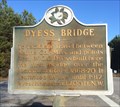 view gallery view gallerySW44.4 km |  Dyess Bridge - Waynesboro, MS Dyess Bridge - Waynesboro, MS
in Mississippi Historical Markers Located at the intersection of Dyess Bridge Road and Big Rock Road, marker notes the history of a first bridge over a nearby river east of Waynesboro. posted by: hoteltwo location: Mississippi date approved: 02/06/2015 last visited: never |
 view gallery view gallery E47.2 km E47.2 km
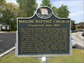
| Shiloh Baptist Church - Dixons Mill, AL in Alabama Historical Markers Marker notes the long history of the many iterations of the Shiloh Churches. posted by: hoteltwo location: Alabama date approved: 04/14/2014 last visited: never |
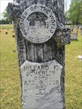
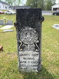 view gallery view galleryE47.2 km |  James Guy Norris - Shiloh Baptist Church Cemetery - Shiloh, AL James Guy Norris - Shiloh Baptist Church Cemetery - Shiloh, AL
in Woodmen of the World Grave Markers/Monuments Located on Shiloh Church Road (County Road 82) this WOW tombstone is shorter than other similar tree stones. posted by: hoteltwo location: Alabama date approved: 04/13/2014 last visited: never |
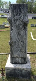 view gallery view galleryE47.2 km | T.L. Stephens - Shiloh Baptist Church Cemetery - Shiloh, AL in Woodmen of the World Grave Markers/Monuments Located in a historic cemetery on Shiloh Church Rd (County Road 82) this tree stone is of the standard type. posted by: hoteltwo location: Alabama date approved: 04/13/2014 last visited: never |
 view gallery view galleryE47.3 km | M.F. Sumerlin - Shiloh Baptist Church Cemetery - Shiloh, AL in Woodmen of the World Grave Markers/Monuments Located in a historic cemetery on Shiloh Church Rd (County Road 82) this tree stone is of the standard type. posted by: hoteltwo location: Alabama date approved: 04/13/2014 last visited: never |
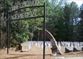
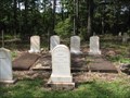 view gallery view gallerySE48.6 km |  Clarkesville Cemetery - Clarkesville, Alabama Clarkesville Cemetery - Clarkesville, Alabama
in Worldwide Cemeteries Rural cemetery near the former town of Clarkesville, Alabama. posted by:  BruceS BruceS location: Alabama date approved: 10/29/2009 last visited: never |
 view gallery view gallery N48.8 km N48.8 km
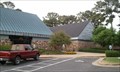
|  Alabama Welcome Center - I-59/20 EB - Cuba, AL Alabama Welcome Center - I-59/20 EB - Cuba, AL
in Highway Rest Areas This is the Alabama Welcome Center on I-59/20 Eastbound between the State Line and Exit 1. posted by: Robert04 location: Alabama date approved: 07/02/2012 last visited: 07/25/2017 |
 view gallery view galleryN48.8 km |  AL-MS I-20 AL-MS I-20
in Border Crossings I-20 posted by: tiki-4 location: Mississippi date approved: 08/23/2007 last visited: 07/25/2017 |
 view gallery view galleryE48.9 km |  Thomasville AFS, AL Thomasville AFS, AL
in Abandoned Air Force Radar Sites Thomasville AFS near Thomasville, AL posted by: APLZ location: Alabama date approved: 01/05/2012 last visited: never |
 view gallery view gallerySE48.9 km | First Clarke County Courthouse - Clarksville, Alabama in Alabama Historical Markers Historical marker marking the location of the first courthouse for Clarke County Alabama. posted by: BruceS location: Alabama date approved: 10/31/2009 last visited: never |
 view gallery view gallerySW49.1 km | Gray Family Cemetery - Waynesboro, MS in Mississippi Historical Markers Located on US 45 just north of Waynesboro, this marker notes one of the founding families of the area. The cemetery is located to the west about 1 mile at the end of the marker road. posted by: hoteltwo location: Mississippi date approved: 02/06/2015 last visited: never |
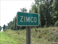 view gallery view gallerySE49.7 km |  Zimco, Alabama Zimco, Alabama
in 'Z' Welcome Signs Small "town" of Zimco, Alabama. posted by: BruceS location: Alabama date approved: 10/28/2009 last visited: never |
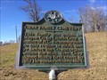
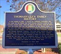 view gallery view galleryE50.9 km | Thomasville's Early History - Thomasville, AL in Alabama Historical Markers Describes the history, industry, railroad impact and the disasters that affected the city of Thomasville. Marker located downtown, on Wilson Ave., near the railroad tracks. posted by: hoteltwo location: Alabama date approved: 03/02/2017 last visited: never |
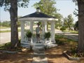 view gallery view galleryE51 km |  Eagle's Nest Eagle's Nest
in Eagle Scout Project Sites Gazebo and Landscaping at Pineview Baptist Church posted by: menawa location: Alabama date approved: 06/10/2006 last visited: 02/08/2010 |
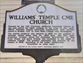 view gallery view galleryE51.2 km | Williams’ Temple CME Church - Thomasville, AL in Alabama Historical Markers Describes the use of the African-American church use also as a school and its history and connection to Miles College in Birmingham. It is located on Davis Avenue, east of East Front Street. posted by: hoteltwo location: Alabama date approved: 03/02/2017 last visited: never |
 view gallery view gallery NE52.5 km NE52.5 km
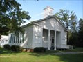
|  Jefferson Baptist Church - Jefferson, Alabama Jefferson Baptist Church - Jefferson, Alabama
in NRHP Historic Districts - Contributing Buildings Historic Baptist church in the small community of Jefferson, Alabama. posted by: BruceS location: Alabama date approved: 10/26/2009 last visited: never |
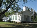 view gallery view galleryNE52.5 km |  Jefferson Baptist Church - Jefferson, AL Jefferson Baptist Church - Jefferson, AL
in Baptist Churches An old country church located in the tiny community of Jefferson, AL posted by: Lazer location: Alabama date approved: 03/01/2009 last visited: 09/25/2009 |
|