 view gallery view gallery SE1.8 km SE1.8 km
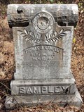
|   Thomas J. Sampley - Jordan Cemetery - Fort Deposit, AL Thomas J. Sampley - Jordan Cemetery - Fort Deposit, AL
in Woodmen of the World Grave Markers/Monuments WOW monument for Thomas J. Sampley, born Sept 14, 1863 and died Nov 13, 1917. posted by:  hoteltwo hoteltwo location: Alabama date approved: 09/12/2013 last visited: never |
 view gallery view gallery E6.6 km E6.6 km
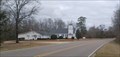
|  Little Sandy Ridge Presbyterian Church - Fort Deposit, AL Little Sandy Ridge Presbyterian Church - Fort Deposit, AL
in Presbyterian Churches This country church is about five miles southwest of Sandy Ridge, Alabama. posted by:  The Snowdog The Snowdog location: Alabama date approved: 01/30/2023 last visited: never |
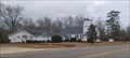 view gallery view galleryE6.6 km |  Little Sandy Ridge Presbyterian Church and Cemetery - Fort Deposit, AL Little Sandy Ridge Presbyterian Church and Cemetery - Fort Deposit, AL
in Churchyard Cemeteries Little Sandy Ridge Presbyterian Church and Cemetery are on Country Road 79, about five miles southwest of Sandy Ridge, Alabama. posted by: The Snowdog location: Alabama date approved: 01/27/2023 last visited: never |
 view gallery view galleryE6.6 km |  Little Sandy Ridge Cemetery - Fort Deposit, AL Little Sandy Ridge Cemetery - Fort Deposit, AL
in Worldwide Cemeteries This country cemetery is on the west side of Country Road 79, about five miles southwest of Sandy Ridge, Alabama. posted by: The Snowdog location: Alabama date approved: 01/27/2023 last visited: never |
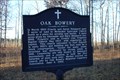 view gallery view gallerySE10.6 km |  Oak Bowery Oak Bowery
in Alabama Historical Markers Marker placed at site of Methodist Episcopal Church South by the Oak Bowery Memorial Cemetery Association. posted by: OHail location: Alabama date approved: 12/18/2011 last visited: 12/19/2013 |
 view gallery view gallery S11.6 km S11.6 km
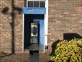
|  Payphone I-65 Southbound - Greenville, Alabama Payphone I-65 Southbound - Greenville, Alabama
in Payphones This phone is outside the Rest Area located at mile marker 133 on I-65 Southbound in Butler County, about 3 miles from the Greenville, Alabama, exit. posted by: xptwo location: Alabama date approved: 01/27/2012 last visited: never |
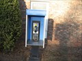 view gallery view galleryS11.6 km | Payphone I-65 Northbound - Greenville, Alabama in Payphones This phone is outside the Rest Area located at mile marker 133 on I-65 Northbound in Butler County, about 3 miles from the Greenville, Alabama, exit. posted by: xptwo location: Alabama date approved: 10/05/2013 last visited: never |
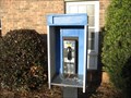 view gallery view galleryS11.6 km | Payphone I-65 Northbound - Greenville, Alabama in Payphones This phone is outside the Rest Area located at mile marker 133 on I-65 Northbound in Butler County, about 3 miles from the Greenville, Alabama, exit. posted by: xptwo location: Alabama date approved: 01/21/2012 last visited: never |
 view gallery view gallery SW12.4 km SW12.4 km
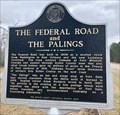
| The Federal Road and The Palings - Greenville, AL in Alabama Historical Markers The Federal Road was designated as a postal route through the Creek Indian frontier in lower Alabama. The marker is located at the Fort Dale Cemetery, on Fort Dale Rd, NW of Greenville. posted by: hoteltwo location: Alabama date approved: 02/17/2019 last visited: never |
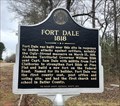 view gallery view gallerySW12.4 km | Fort Dale 1818 - Greenville, AL in Alabama Historical Markers Describes the fort built by Captain Dale to protect settlers from Indian attacks during the Creek Wars. The marker is located at the Fort Dale Cemetery, on Fort Dale Rd, NW of Greenville. posted by: hoteltwo location: Alabama date approved: 02/17/2019 last visited: never |
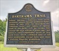 view gallery view gallerySW14.3 km | Bartram's Trail - Greenville, AL in Alabama Historical Markers William Bartram traveled the Southeast U.S., including Butler County, from 1773 through 1777. He published observations of plants, animals, geography and people in 1791. Marker located along Sherling Lake Road west of Braggs Road. posted by: hoteltwo location: Alabama date approved: 08/18/2018 last visited: never |
 view gallery view gallery NW14.8 km NW14.8 km
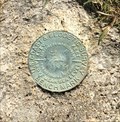
|  USCGS Benchmark CN0878 - Mt Willing, AL USCGS Benchmark CN0878 - Mt Willing, AL
in U.S. Benchmarks This bench mark is located next to the former Snow Hill Christian Church Annex on AL-21 at Snow Hill Dr. It is in excellent condition. posted by: hoteltwo location: Alabama date approved: 08/12/2020 last visited: never |
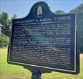 view gallery view galleryNW14.8 km | Enslavement & Racial Terror - Mt Willing, AL in Alabama Historical Markers Located along AL-21 at Snow Hill Drive, this marker describes the devastating violence that once took place in Alabama. More than 350 African-Americans were lynched in Alabama in 66 years of which 16 were killed in this county. posted by: hoteltwo location: Alabama date approved: 09/16/2020 last visited: never |
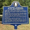 view gallery view galleryNW14.8 km | Lynching Targeting Black Sharecroppers - Mt Willing, AL in Alabama Historical Markers Marker memorializes the lynchings of Mr. Ed Bracy, Mr. Jim Press Meriweather, and Rev. G. Smith Watkins, three Black sharecroppers and union leaders lynched in Lowndes County in 1935. Marker is located near Mt Willing Church on AL-21. posted by: hoteltwo location: Alabama date approved: 09/16/2020 last visited: never |
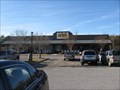 view gallery view galleryS15.4 km |  Cracker Barrel - I-65 Exit 130 - Greenville, Alabama Cracker Barrel - I-65 Exit 130 - Greenville, Alabama
in Cracker Barrel Restaurants This Cracker Barrel is located near I-65, Exit 130 in Greenville, Alabama. This is the Alabama 185 exit. It is on the west side of the interstate. posted by: xptwo location: Alabama date approved: 04/02/2012 last visited: 04/30/2021 |
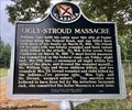 view gallery view gallerySW16.9 km | Ogly-Stroud Massacre - Greenville, AL in Alabama Historical Markers Located northwest of Greenville, at the Old Shiloh Cemetery, along Sherling Lake Road. This marker notes one of the two Indian massacres, that occurred in March, 1818, in Butler County. posted by: hoteltwo location: Alabama date approved: 08/18/2018 last visited: never |
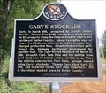 view gallery view gallerySW16.9 km | Gary's Stockade - Greenville, AL in Alabama Historical Markers Due to Indian attacks, a settler built a block house and charged other settlers to use it. An Indian massacre nearby led the government to build a fort, making this one useless. Located northwest of Greenville, at the Old Shiloh Cemetery. posted by: hoteltwo location: Alabama date approved: 08/18/2018 last visited: never |
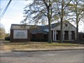 view gallery view galleryS17.5 km |  Greenville-Butler County Library - Greenville, Alabama Greenville-Butler County Library - Greenville, Alabama
in Libraries The Greenville - Butler County Library is a library of some 50,000 volumes serving this Alabama community located about 30 minutes south of Montgomery. posted by: xptwo location: Alabama date approved: 01/16/2012 last visited: never |
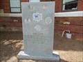 view gallery view galleryS17.5 km |  Desert Storm Memorial - Greenville, AL Desert Storm Memorial - Greenville, AL
in Persian Gulf War Memorials This memorial to those who served in Desert Storm is located outside the Butler County Courthouse in Greenville, Alabama. posted by: xptwo location: Alabama date approved: 10/27/2013 last visited: 01/27/2023 |
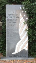 view gallery view galleryS17.7 km |  Vietnam War Memorial, Courthouse Grounds, Greenville, AL, USA Vietnam War Memorial, Courthouse Grounds, Greenville, AL, USA
in Vietnam War Memorials Located on the Butler County Courthouse grounds at 700 Court Square, this monument is dedicated to those KIA in the Vietnam War. posted by: hoteltwo location: Alabama date approved: 12/25/2013 last visited: 01/27/2023 |
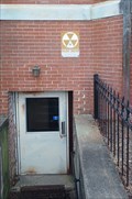 view gallery view galleryS17.7 km |  Butler County Courthouse - Greenville, AL Butler County Courthouse - Greenville, AL
in Civil Defense Fallout Shelters The east basement entrance to the Butler County Courthouse is a fallout shelter - in Greenville, Alabama. posted by: The Snowdog location: Alabama date approved: 01/28/2023 last visited: never |
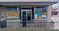 view gallery view galleryS17.7 km |  Docarmo's Taekwondo Center- Greenville, AL Docarmo's Taekwondo Center- Greenville, AL
in Martial Arts Docarmo's Taekwondo Center is on historic E. Commerce Street, just west of the Butler County Courthouse - in Greenville, Alabama. posted by: The Snowdog location: Alabama date approved: 01/28/2023 last visited: never |
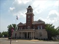 view gallery view galleryS17.7 km | Butler County Courthouse Dome (BU1876) - Greenville, AL in U.S. Benchmarks The dome on the Butler County Courthouse in Greenville, Alabama, was used for surveying purposes in 1944. posted by: xptwo location: Alabama date approved: 08/10/2013 last visited: 01/27/2023 |
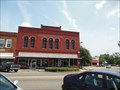 view gallery view galleryS17.7 km |  Capps Drugstore - - East Commerce Street Historic District - Greenville, AL Capps Drugstore - - East Commerce Street Historic District - Greenville, AL
in NRHP Historic Districts - Contributing Buildings The businesses in the application are no longer there, but the building remains. There was a barber shop at 605, but the one now at that address has a different name. posted by: xptwo location: Alabama date approved: 08/14/2013 last visited: never |
 view gallery view galleryS17.7 km | Greenville Hardware - East Commerce Street Historic District - Greenville, AL in NRHP Historic Districts - Contributing Buildings The sign on this building indicates it still houses the Greenville Hardware store. While the second floor windows have been bricked in, one can tell where they were located in the days before air-conditioning. posted by: xptwo location: Alabama date approved: 08/14/2013 last visited: never |
|