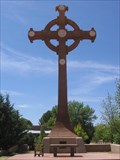
 view gallery view gallery N1.8 km N1.8 km
|   Shrine of the True Cross - St. David, AZ Shrine of the True Cross - St. David, AZ
in Christian Crosses Celtic Cross located on the grounds of the Holy Trinity Monastery just south of St. David, AZ. posted by:  HiFiLZ HiFiLZ location: Arizona date approved: 05/04/2008 last visited: 06/18/2021 |
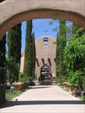 view gallery view galleryN1.8 km |  Our Lady of Guadalupe Church - St. David, AZ Our Lady of Guadalupe Church - St. David, AZ
in Roman Catholic Churches Church located on the grounds of the Holy Trinity Monastery in St. David, AZ. posted by: HiFiLZ location: Arizona date approved: 05/22/2008 last visited: 04/27/2011 |
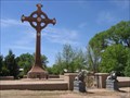 view gallery view galleryN1.8 km |  Holy Trinity Monastery - St. David, AZ Holy Trinity Monastery - St. David, AZ
in Abbeys, Convents and Monasteries Benedictine monastery located along Hwy 80 south of St. David, AZ. posted by: HiFiLZ location: Arizona date approved: 05/04/2008 last visited: 08/20/2019 |
 view gallery view gallery NW3.9 km NW3.9 km
|  Apache Powder Company- St. David, AZ Apache Powder Company- St. David, AZ
in Super Fund Sites Site of an operation manufacturing industrial chemicals and explosives which resulted in soil and groundwater contamination. posted by:  linkys linkys location: Arizona date approved: 01/03/2010 last visited: 09/02/2019 |
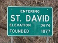
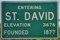 view gallery view galleryN4 km |  Saint David, Arizona (Southern Approach) ~ Elevation 3676 Feet Saint David, Arizona (Southern Approach) ~ Elevation 3676 Feet
in Elevation Signs This Elevation Sign is located on the east side of Arizona Highway 80 at the southern town limit of Saint David, Arizona. posted by: brwhiz location: Arizona date approved: 02/12/2013 last visited: 07/11/2014 |
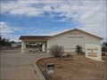
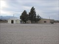 view gallery view galleryN4.7 km |  First Baptist Church - St. David, AZ First Baptist Church - St. David, AZ
in Baptist Churches Small Baptist Church in a small Arizona town. posted by: linkys location: Arizona date approved: 12/31/2009 last visited: 04/27/2011 |
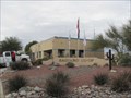
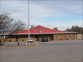
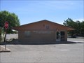 view gallery view galleryN5 km |  St. David, AZ 85630 St. David, AZ 85630
in U.S. Post Offices U.S. Post Office located along Miller Lane in St. David, AZ, USA. posted by: HiFiLZ location: Arizona date approved: 05/04/2008 last visited: 09/17/2011 |
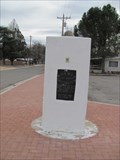 view gallery view galleryN5 km |  Mormon Battalion Marker - St David, AZ Mormon Battalion Marker - St David, AZ
in Smithsonian Art Inventory Sculptures A monument commemorating the Mormon Battalion's camp in 1846, and Capt Merrill's return in 1877. posted by: linkys location: Arizona date approved: 12/30/2009 last visited: 08/17/2022 |
 view gallery view galleryN5 km |  Mormon Battalion Monument - St David, AZ Mormon Battalion Monument - St David, AZ
in Arizona Historical Markers A monument concerning the Mormon Battalion's camp in 1846. posted by: linkys location: Arizona date approved: 01/05/2010 last visited: 08/17/2022 |
 view gallery view galleryN5.1 km | St. David, AZ - 3676 Feet in Elevation Signs An elevation sign on Hwy 80 at the north side of St. David. posted by: linkys location: Arizona date approved: 01/02/2010 last visited: 08/18/2013 |
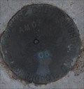
 view gallery view gallery SE6.1 km SE6.1 km
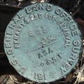
|  S35 1/4 ASA2451 1916 S35 1/4 ASA2451 1916
in U.S. Benchmarks I was looking for the FARO triangulation station and its RMs, when I came across this old station. posted by: MIG2 location: Arizona date approved: 02/26/2012 last visited: never |
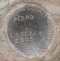 view gallery view galleryNW6.1 km | PEDRO LS303.65 2005 COCHISE COUNTY in U.S. Benchmarks A benchmark listed in the NGS database, but not the GC.com database. posted by: MIG2 location: Arizona date approved: 02/24/2012 last visited: never |
 view gallery view galleryNW11.9 km |  SKP RV PARK - Benson, AZ SKP RV PARK - Benson, AZ
in Bookcrossing Zones Book release site at an RV park for retirees who travel to Arizona for the warm temperatures in the winter. posted by: linkys location: Arizona date approved: 01/03/2010 last visited: 11/28/2014 |
 view gallery view galleryNW11.9 km |  Turquoise Hills Golf & RV - Benson, AZ Turquoise Hills Golf & RV - Benson, AZ
in Public and Private Golf Courses Executive length course offering a golf and RV package as well as regular public play. posted by: linkys location: Arizona date approved: 12/30/2009 last visited: 06/18/2021 |
 view gallery view galleryNW12.9 km | AMOX DK7527 COCHISE COUNTY HIGHWAY AND FLOODPLAN DEPT. LS36365 2005 in U.S. Benchmarks This is a floodplan survey mark. posted by: MIG2 location: Arizona date approved: 02/19/2012 last visited: never |
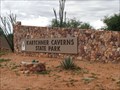 view gallery view gallery W13 km W13 km
|  Kartchner Caverns State Park - Benson, AZ Kartchner Caverns State Park - Benson, AZ
in State/Provincial Parks Kartchner Caverns State Park in Southeastern Arizona features a stunning and pristine limestone cave with world-class features that have been protected since its discovery in 1974. posted by: Poehunters location: Arizona date approved: 07/17/2013 last visited: 02/05/2018 |
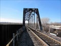
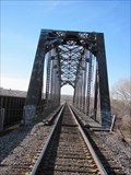 view gallery view galleryNW13.2 km |  San Pedro River RR Bridge - Benson, AZ San Pedro River RR Bridge - Benson, AZ
in Truss Bridges Older steel truss railroad bridge across the San Pedro River east of town. posted by: linkys location: Arizona date approved: 01/02/2010 last visited: 07/14/2012 |
 view gallery view galleryNW13.2 km |  San Pedro River RR Bridge - Benson, AZ San Pedro River RR Bridge - Benson, AZ
in Railroad Bridges Double bridge across the river east of town. posted by: linkys location: Arizona date approved: 01/04/2010 last visited: 07/14/2012 |
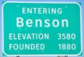 view gallery view galleryNW13.4 km | Benson, Arizona (Eastern Approach) ~ Elevation 3580 Feet in Elevation Signs This Elevation Sign is located on the north side of 4th Street (Interstate Highway 10 Business) at the eastern town limit of Benson, Arizona. posted by: brwhiz location: Arizona date approved: 02/12/2013 last visited: 07/11/2014 |
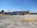
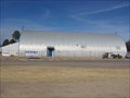 view gallery view galleryNW13.4 km |  Currently For Sale - Benson, AZ Currently For Sale - Benson, AZ
in Quonset Huts A large quonset hut that sports a "For Sale" sign (12/09) on the east side of Benson, AZ. It appears to be currently occupied by a construction company. posted by: linkys location: Arizona date approved: 12/17/2009 last visited: 04/24/2011 |
 view gallery view galleryW13.4 km |  Kartchner Caverns State Park Penny Smasher Kartchner Caverns State Park Penny Smasher
in Penny Smashers This four-design Penny Smasher is in the Kartchner Caverns State Park Visitor Center at 2950 S Highway 90 south of Benson, Arizona. posted by: brwhiz location: Arizona date approved: 10/22/2011 last visited: 12/06/2014 |
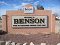 view gallery view galleryNW13.4 km |  Benson, AZ Benson, AZ
in Welcome Signs Welcome sign for the I-10 town of Benson, AZ. posted by: linkys location: Arizona date approved: 12/20/2009 last visited: 04/24/2011 |
 view gallery view galleryNW13.5 km |  Kingdom Hall of Jehovah's Witnesses - Benson, AZ Kingdom Hall of Jehovah's Witnesses - Benson, AZ
in Kingdom Halls of Jehovah's Witnesses Kingdom Hall on Hwy 80 just south of Benson, next door to the Methodist church. posted by: linkys location: Arizona date approved: 01/06/2010 last visited: 04/24/2011 |
 view gallery view galleryNW13.5 km |  San Pedro Valley United Methodist Church - Benson, AZ San Pedro Valley United Methodist Church - Benson, AZ
in Methodist Churches Small, but active Methodist congregation on the southeast side of Benson. posted by: linkys location: Arizona date approved: 12/26/2009 last visited: 04/24/2011 |
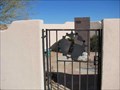 view gallery view galleryNW13.5 km |  San Pedro Valley United Methodist Church - Benson, AZ San Pedro Valley United Methodist Church - Benson, AZ
in Churchyard Cemeteries Small columbarium on the church grounds. posted by: linkys location: Arizona date approved: 01/15/2010 last visited: 07/06/2021 |
|