 view gallery view gallery N5.8 km N5.8 km
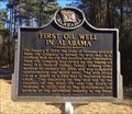
|   First Oil Well In Alabama - Gilbertown, AL First Oil Well In Alabama - Gilbertown, AL
in Alabama Historical Markers Located 2 miles west of Gilbertown on Paragon Rd, marker notes the beginnings of the oil industry in Alabama by H.L. Hunt of Texas. posted by:  hoteltwo hoteltwo location: Alabama date approved: 02/08/2015 last visited: 01/15/2018 |
 view gallery view gallery SW22.7 km SW22.7 km
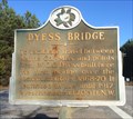
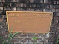
|  Dyess Bridge - Waynesboro, MS Dyess Bridge - Waynesboro, MS
in Mississippi Historical Markers Located at the intersection of Dyess Bridge Road and Big Rock Road, marker notes the history of a first bridge over a nearby river east of Waynesboro. posted by: hoteltwo location: Mississippi date approved: 02/06/2015 last visited: never |
 view gallery view gallery E23.8 km E23.8 km
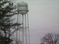
|  Coffeeville, AL WT Coffeeville, AL WT
in Water Towers Municipal Water Tower for Coffeeville, AL posted by:  Six Little Spookies Six Little Spookies location: Alabama date approved: 01/20/2008 last visited: never |
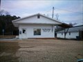
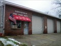 view gallery view galleryE23.8 km |  Coffeevillle Vol Fire Dept Coffeevillle Vol Fire Dept
in Firehouses Firehouse for the volunteer firefighters of Coffeeville, Al. posted by: Six Little Spookies location: Alabama date approved: 01/31/2008 last visited: never |
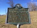
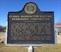 view gallery view galleryE24.1 km | Clarke-Washington Electric Membership Corporation - Coffeeville, AL in Alabama Historical Markers Located at the intersection of U.S. 84 and River Street, marker notes the history of bringing electric power to the black belt counties of Clarke and Washington. posted by: hoteltwo location: Alabama date approved: 02/08/2015 last visited: 08/27/2019 |
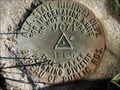 view gallery view galleryE24.3 km |  Ala. State Hwy. Dept. JC71 1964 Ala. State Hwy. Dept. JC71 1964
in U.S. Benchmarks Alabama State Highway Department benchmark in Coffeeville, Clarke County, Alabama posted by: jkselby location: Alabama date approved: 01/15/2008 last visited: never |
 view gallery view gallery SE25.7 km SE25.7 km
|  Frankville, AL 36538 Frankville, AL 36538
in U.S. Post Offices Frankville Alabama Post Office posted by: Six Little Spookies location: Alabama date approved: 02/06/2008 last visited: never |
 view gallery view gallery W31.7 km W31.7 km
| Gray Family Cemetery - Waynesboro, MS in Mississippi Historical Markers Located on US 45 just north of Waynesboro, this marker notes one of the founding families of the area. The cemetery is located to the west about 1 mile at the end of the marker road. posted by: hoteltwo location: Mississippi date approved: 02/06/2015 last visited: never |
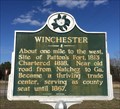 view gallery view gallerySW32.7 km | Former Community of Winchester - Waynesboro, MS in Mississippi Historical Markers Winchester was one of the first significant communities in western Mississippi and the County Seat but today is covered by forest. posted by: hoteltwo location: Mississippi date approved: 02/06/2015 last visited: never |
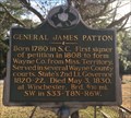 view gallery view gallerySW33.5 km | General James Patton - Waynesboro, MS in Mississippi Historical Markers Marker is at the intersection of Old 45 Winchester Road and Winchester Cross Road and notes the early settler of the area. posted by: hoteltwo location: Mississippi date approved: 02/06/2015 last visited: never |
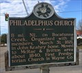 view gallery view gallerySW33.6 km | Philadelphus Church - Waynesboro, MS in Mississippi Historical Markers Marker is at the intersection of Mississippi Drive (Mississippi Route 145) and Wayne Street and notes a short history and the direction of a rural church. posted by: hoteltwo location: Mississippi date approved: 02/06/2015 last visited: never |
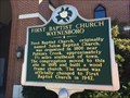 view gallery view gallerySW33.6 km | First Baptist Church - Waynesboro, MS in Mississippi Historical Markers Marker is at the intersection of Azalea Drive (Mississippi Route 184) and Mississippi drive (Mississippi Route 145) and describes the beginnings of the First Baptist Church in Waynesboro. posted by: hoteltwo location: Mississippi date approved: 02/06/2015 last visited: never |
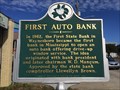 view gallery view gallerySW34 km | First Auto Bank - Waynesboro, MS in Mississippi Historical Markers Marker located at the intersection of Azalea Drive (Mississippi Route 184) and Fagan Avenue and is unused today as a bank. You can still see the 2 drive up windows at this small bank. posted by: hoteltwo location: Mississippi date approved: 02/06/2015 last visited: never |
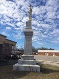 view gallery view gallerySW34.1 km |  Wayne County Civil War Monument - Waynesboro, MS Wayne County Civil War Monument - Waynesboro, MS
in American Civil War Monuments and Memorials Monument is at the intersection of Chickasawhay St. and Azalea Dr. (MS Route 184) by the east side of the Justice Court building. Previously it was located in front of the Waynesboro High School before the school was torn down. posted by: hoteltwo location: Mississippi date approved: 02/04/2015 last visited: never |
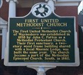 view gallery view gallerySW34.3 km | First United Methodist Church - Waynesboro, MS in Mississippi Historical Markers Marker is at the intersection of Turner Street (Mississippi Route 63) and Wayne Street and describes the early history of this Methodist Church. posted by: hoteltwo location: Mississippi date approved: 02/06/2015 last visited: never |
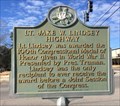 view gallery view gallerySW34.3 km | Lt. Jake W. Lindsey Highway - Waynesboro, MS in Mississippi Historical Markers Marker is at the intersection of Turner Street (Mississippi Route 63) and Azalea Drive (Mississippi Route 184) and notes a local soldier who earned the nation's highest military decoration, the Medal of Honor. posted by: hoteltwo location: Mississippi date approved: 02/06/2015 last visited: never |
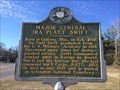 view gallery view gallerySW37 km | Major General Ira Platt Swift - Buckatunna, MS in Mississippi Historical Markers Notes the life of US Army Major General Swift and is located at the intersection of Buckatunna-Chicora-Clara Road and Chicora-State Line Road. posted by: hoteltwo location: Mississippi date approved: 02/06/2015 last visited: never |
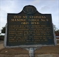 view gallery view gallerySE40.6 km | Old St. Stephens Masonic Lodge No. 9 (1821-1834) - St. Stephens, AL in Alabama Historical Markers The original Masonic Lodge #9 here declined and closed and was later reopened as Masonic Lodge #81. posted by: hoteltwo location: Alabama date approved: 12/06/2013 last visited: never |
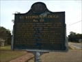 view gallery view gallerySE40.6 km | St. Stephens Lodge No. 81 - St. Stephens, AL in Alabama Historical Markers St. Stephens Lodge #81 is a regular and recognized masonic lodge located in St. Stephens, AL. posted by: hoteltwo location: Alabama date approved: 12/06/2013 last visited: never |
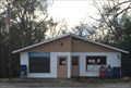 view gallery view gallerySE40.6 km | St. Stephens, AL 36569 in U.S. Post Offices Rural post office located in the former historical Washington County Seat town of St. Stephens. posted by: hoteltwo location: Alabama date approved: 12/06/2013 last visited: never |
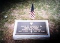 view gallery view gallerySW41.2 km |  Jake W Lindsey-Clara, MS Jake W Lindsey-Clara, MS
in Medal Of Honor Resting Places World War II Medal of Honor Recipient for action near Hamich, Germany on November 16, 1944. He is buried in Whitehouse Cemetery, Clara MS. posted by: Don.Morfe location: Mississippi date approved: 11/25/2017 last visited: 12/19/2021 |
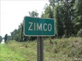 view gallery view galleryE43.5 km |  Zimco, Alabama Zimco, Alabama
in 'Z' Welcome Signs Small "town" of Zimco, Alabama. posted by:  BruceS BruceS location: Alabama date approved: 10/28/2009 last visited: never |
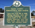 view gallery view gallerySW43.8 km | Wayne County Agricultural High School - Clara, MS in Mississippi Historical Markers Marker notes the former location of a county vocational school and is located on Clara School Road just south of Mississippi Route 63. posted by: hoteltwo location: Mississippi date approved: 02/06/2015 last visited: never |
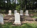 view gallery view galleryE43.8 km |  Clarkesville Cemetery - Clarkesville, Alabama Clarkesville Cemetery - Clarkesville, Alabama
in Worldwide Cemeteries Rural cemetery near the former town of Clarkesville, Alabama. posted by: BruceS location: Alabama date approved: 10/29/2009 last visited: never |
 view gallery view galleryE43.9 km | First Clarke County Courthouse - Clarksville, Alabama in Alabama Historical Markers Historical marker marking the location of the first courthouse for Clarke County Alabama. posted by: BruceS location: Alabama date approved: 10/31/2009 last visited: never |
|