 view gallery view gallery E4.3 km E4.3 km
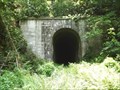
|   Tunnel Springs, AL Abandoned Train Tunnel Tunnel Springs, AL Abandoned Train Tunnel
in Abandoned Train Tunnels Abandoned Train Tunnel located near the town of Tunnel Springs, Alabama. posted by:  Six Little Spookies Six Little Spookies location: Alabama date approved: 12/30/2007 last visited: 04/12/2014 |
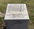
 view gallery view galleryE13.4 km |  Old Federal Road - Pine Orchard, AL Old Federal Road - Pine Orchard, AL
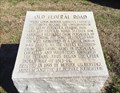
in Alabama Historical Markers One of eight stone markers along the Alabama portion of the Federal road established as a postal route by President Jefferson. Located on County Road 5, south of County Road 42. posted by:  hoteltwo hoteltwo location: Alabama date approved: 03/24/2015 last visited: never |
 view gallery view gallery SE15 km SE15 km
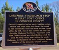
| Longmire Stagecoach Stop - Burnt Corn, AL in Alabama Historical Markers Marker located along the rural County Road 5, north of Burnt Corn. Notes the early history of Conecuh County postal service. posted by: hoteltwo location: Alabama date approved: 03/22/2015 last visited: never |
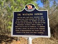 view gallery view gallerySE15.3 km | Dr. Watkins House - Burnt Corn, AL in Alabama Historical Markers Located on Conecuh County Rd 5, about a mile north of CR-15, notes the house and life of a prominent doctor and politician, John Watkins. posted by: hoteltwo location: Alabama date approved: 03/22/2015 last visited: never |
 view gallery view gallery S16.3 km S16.3 km
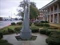
|  Monroeville, AL Eternal Flame Monroeville, AL Eternal Flame
in Eternal Flames Eternal Flame outside the Monroeville, Alabama, Courthouse. posted by: Six Little Spookies location: Alabama date approved: 01/27/2008 last visited: 01/21/2008 |
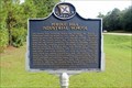
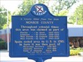 view gallery view galleryS16.3 km | A County Older Then The State - Monroe County in Alabama Historical Markers Monroe County, Alabama is older then the state itself - created in 1815, Alabama did not become a state until 1819. posted by: Thorny1 location: Alabama date approved: 07/11/2008 last visited: 07/31/2011 |
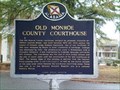 view gallery view galleryS16.3 km | Old Monroe County Courthouse - Monroeville, AL in Alabama Historical Markers Historical Marker commemorating the Old Monroe County Courthouse, made famous from the novel and movie, "To Kill A Mockingbird, posted by: Six Little Spookies location: Alabama date approved: 02/02/2008 last visited: 04/12/2014 |
 view gallery view galleryS16.3 km |  Old Monroe County Courthouse - To Kill A Mockingbird Old Monroe County Courthouse - To Kill A Mockingbird
in Literary Sites Old Monroeville County Courthouse - the setting for the famous courtroom scene in "To Kill A Mockingbird" by Harper Lee. posted by: Thorny1 location: Alabama date approved: 07/22/2008 last visited: 07/11/2010 |
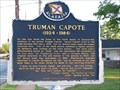 view gallery view galleryS16.6 km | Truman Capote in Alabama Historical Markers Monroeville home of Truman Capote. posted by: Thorny1 location: Alabama date approved: 07/11/2008 last visited: 07/11/2010 |
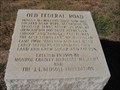
 view gallery view gallerySE16.9 km | Old Federal Road - Burnt Corn, AL in Alabama Historical Markers One of eight stone markers along the Alabama portion of the Federal road established as a postal route by President Jefferson. Located at the intersection of County Road 5 and County Road 15. posted by: hoteltwo location: Alabama date approved: 03/24/2015 last visited: never |
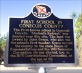 view gallery view gallerySE18.3 km | First School in Conecuh County - Burnt Corn, AL in Alabama Historical Markers Located on Conecuh County Road 15, east of County Road 5 this marker notes the former location of the first school in this rural county. posted by: hoteltwo location: Alabama date approved: 03/22/2015 last visited: never |
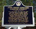 view gallery view gallerySE19 km | John Green Cemetery - Burnt Corn, AL in Alabama Historical Markers Located near the community of Burnt Corn, this cemetery contains Civil War and war of 1812 graves. The cemetery is well off the main road and you will need some GPS sense to find it. The cemetery is now well taken care of. posted by: hoteltwo location: Alabama date approved: 03/12/2015 last visited: never |
 view gallery view gallery W19.6 km W19.6 km
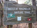
|  Big Leaf Magnolia Nature Trail, Haines Island Park, Monroe County, Alabama Big Leaf Magnolia Nature Trail, Haines Island Park, Monroe County, Alabama
in Hiking and walking trailheads Hiking trail at U.S. Army Corps of Engineers Haines Island Park on the Alabama River posted by: jkselby location: Alabama date approved: 01/12/2011 last visited: never |
 view gallery view galleryE20.6 km | Old Federal Road - Midway Alabama in Alabama Historical Markers One of eight stone markers along the Alabama portion of the Federal road established as a postal route by President Jefferson. Located at the intersection of County Road 1 and State Route 83 in Conecuh County. posted by: hoteltwo location: Alabama date approved: 03/24/2015 last visited: never |
 view gallery view galleryS21.6 km | Old Federal Road - Bermuda, AL in Alabama Historical Markers One of eight stone markers along the Alabama portion of the Federal road established as a postal route by President Jefferson. Located at the intersection of County Road 5 and County Road 20. posted by: hoteltwo location: Alabama date approved: 03/24/2015 last visited: never |
 view gallery view galleryE21.7 km | Midway - Midway, AL in Alabama Historical Markers Marker notes the community started here and is located at the intersection of State, County and U.S. highways. It should not to be confused with the incorporated town of Midway that’s located in Bullock County. posted by: hoteltwo location: Alabama date approved: 03/12/2015 last visited: never |
 view gallery view gallery SW22 km SW22 km
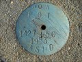
|  1427 + 50 1427 + 50
in U.S. Benchmarks Alabama State Highway Dept. ROW marker on AL 47 near Mexia, Alabama posted by: jkselby location: Alabama date approved: 12/15/2007 last visited: never |
 view gallery view galleryS22.9 km |  Lambert's - Foley, Alabama Lambert's - Foley, Alabama
in Independent Diners Lambert's - Home of the Thrown Rolls, Lambert's Foley, Alabama, location. posted by: gwtriker location: Alabama date approved: 06/03/2010 last visited: 03/06/2015 |
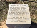
 view gallery view galleryS24.6 km | Old Federal Road - Repton, Alabama in Alabama Historical Markers Marker indicating the location of a stage stop on Old Federal Road. It is located north of Repton, Alabama. posted by: xptwo location: Alabama date approved: 11/30/2011 last visited: 03/07/2015 |
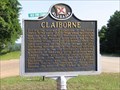 view gallery view gallerySW26.6 km | Claiborne in Alabama Historical Markers Claiborne, AL also entertained LaFayette on his travels in 1825. posted by: Thorny1 location: Alabama date approved: 07/11/2008 last visited: 08/27/2019 |
 view gallery view gallerySW26.6 km | Piache in Alabama Historical Markers Located on US 84 at Old Fort Claiborne Road posted by: Markerman62 location: Alabama date approved: 09/09/2019 last visited: 08/27/2019 |
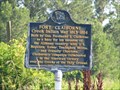 view gallery view gallerySW26.6 km | Fort Claiborne - Monroe County, AL in Alabama Historical Markers Located in Monroe County, AL and built to support the settlers and defend against Creek Indian attacks. posted by: Thorny1 location: Alabama date approved: 07/11/2008 last visited: 08/27/2019 |
 view gallery view gallerySW26.9 km | Perdue Hill Industrial School in Alabama Historical Markers Located on US 84 just west of Dales Ferry Road in Perdue Hill. posted by: Markerman62 location: Alabama date approved: 09/09/2019 last visited: 08/27/2019 |
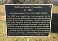 view gallery view gallerySW26.9 km | Dellet-Bedsole Plantation (c.1850) - Whatley, AL in Alabama Historical Markers Located along U.S. 84, 2 miles west of Lena Landegger Highway (County Road 39), on the right when traveling west. It is near the tree lined driveway into the 4000 acre farm. posted by: hoteltwo location: Alabama date approved: 02/08/2015 last visited: never |
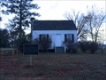 view gallery view gallerySW27 km |  William Barret Travis Home - Perdue Hill, AL William Barret Travis Home - Perdue Hill, AL
in Relocated Structures Relocated home of the Texas hero and commander of the Alamo, William Travis. posted by: hoteltwo location: Alabama date approved: 12/10/2013 last visited: never |
|