 view gallery view gallery SW7.1 km SW7.1 km
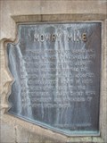
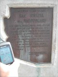
|   Mowry Mine Mowry Mine
in Arizona Historical Markers In 1860 Sylvester Mowry purchased the Patagonia Mine and renamed it the Mowry Mine. A number of Apache attacks and killings occurred at or near this mine. posted by:  leadhiker leadhiker location: Arizona date approved: 05/04/2010 last visited: 11/20/2010 |
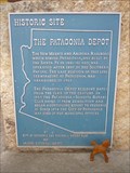 view gallery view gallerySW7.1 km | Patagonia Depot in Arizona Historical Markers The Patagonia Depot was sold in about 1950 to a local businessman, but a local Rotarian purchased it from him. After the Patagonia-Sonoita Club's partial restoration, the Town purchased the building, which still serves as the Town Hall. posted by: leadhiker location: Arizona date approved: 05/04/2010 last visited: never |
 view gallery view gallery N7.1 km N7.1 km
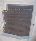
| Camp Crittenden - Sonoita, AZ in Arizona Historical Markers A historical marker for Camp Crittenden, AZ. Established 1867 and deactivated 1873. posted by:  Phydux Phydux location: Arizona date approved: 06/16/2009 last visited: 01/21/2020 |
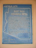 view gallery view gallerySW7.2 km | Cady Hall - Patagonia Hotel in Arizona Historical Markers The Patagonia Hotel, now home to the Patagonia Library and Cady Hall, was constructed
by adventurer, chef, soldier, stage driver and sheep rancher John H. Cady between
1901 and 1912. posted by: leadhiker location: Arizona date approved: 05/04/2010 last visited: 07/08/2010 |
 view gallery view gallery NE10.6 km NE10.6 km
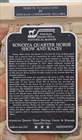
| Sonoita Quarter Horse Show and Races in Arizona Historical Markers One of four American Quarter Horse Heritage Center & Museum Markers in Arizona. posted by: leadhiker location: Arizona date approved: 11/21/2011 last visited: never |
 view gallery view gallerySW12.1 km | John Ward's Ranch in Arizona Historical Markers On January 27, 1861, Indians raided John Ward's ranch on Sonoita Creek, abducting Ward's stepson and stealing cattle.
The incident ignited a war that would not be resolved until 1872. posted by: leadhiker location: Arizona date approved: 05/04/2010 last visited: 03/21/2018 |
 view gallery view gallery S14.5 km S14.5 km
|  Harshaw, Az. - Ghost Town Harshaw, Az. - Ghost Town
in Ghost Towns Harshaw is located South of Patagonia, Az. Harshaw was an active mining community from 1877 to 1903. posted by: outwest63 location: Arizona date approved: 10/14/2013 last visited: never |
 view gallery view galleryN15.6 km |  Santa Rita Water & Mining Co.- Kentucky Camp, AZ Santa Rita Water & Mining Co.- Kentucky Camp, AZ
in Mines Partially restored buildings of Santa Rita Water & Mining Co. founded in 1904 and abandoned shortly thereafter posted by: KBW location: Arizona date approved: 10/04/2010 last visited: 09/23/2021 |
 view gallery view galleryN16.3 km |  Santa Rita Abbey - Sonoita, Arizona (near Tucson) Santa Rita Abbey - Sonoita, Arizona (near Tucson)
in Abbeys, Convents and Monasteries Santa Rita Abbey south of Tucson, Arizona. Please visit their website. posted by: unimoggers location: Arizona date approved: 08/03/2007 last visited: 06/15/2008 |
 view gallery view galleryN17.9 km |  Blackberry Picking at Harris Heritage Growers, Sonoita, AZ Blackberry Picking at Harris Heritage Growers, Sonoita, AZ
in Berry Picking Pick your own Blueberries from early July to late September at Harris Heritage Growers in Sonoita, AZ. posted by: Poehunters location: Arizona date approved: 08/14/2013 last visited: 06/20/2021 |
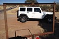 view gallery view galleryN17.9 km |  Get Framed Get Framed
in Framed Views Put yourself in the frame or just the view from that spot.. posted by: grandmabetsy location: Arizona date approved: 12/27/2013 last visited: 12/27/2013 |
 view gallery view gallery E19.6 km E19.6 km
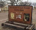
|  The Village of Elgin Winery-Arizona The Village of Elgin Winery-Arizona
in Wineries The Village of Elgin Winery and Tasting Room. posted by: grandmabetsy location: Arizona date approved: 03/12/2018 last visited: 06/18/2021 |
 view gallery view gallery W22.2 km W22.2 km
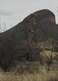
|  Devil's Throne Bench Mark Devil's Throne Bench Mark
in U.S. Benchmarks Tough climb to the top of Devil's Throne. posted by: Cactus Monkey location: Arizona date approved: 02/21/2011 last visited: 02/20/2011 |
 view gallery view galleryNE22.7 km |  Lonely Chimney along Upper Egin Rd.-Arizona Lonely Chimney along Upper Egin Rd.-Arizona
in Lonely Chimneys Spotted this lonely chimney next to the road. posted by: grandmabetsy location: Arizona date approved: 03/12/2018 last visited: never |
 view gallery view galleryNE23.5 km | San Ignacia del Babocomari in Arizona Historical Markers I found this gem back in July of 2005 because I'm a big marker fan. What a story! Can you imagine the robbery!!?? I tried to find a website to learn more. No avail. posted by: unimoggers location: Arizona date approved: 09/22/2007 last visited: 12/31/2012 |
 view gallery view galleryW24 km |  San Cayetano Top Hop San Cayetano Top Hop
in Summit Registers A summit Register for the second highest peak in the San Cayetano range. posted by: Phydux location: Arizona date approved: 06/14/2009 last visited: 05/10/2014 |
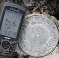
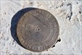
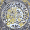 view gallery view galleryE25.3 km | USGS ASA1465 Cochise Co. Arizona in U.S. Benchmarks USGS Benchmark mounted on a boulder just out the West gate of Fort Huachuca, Arizona. posted by: Phydux location: Arizona date approved: 01/05/2009 last visited: 05/10/2014 |
 view gallery view galleryS30.4 km |  Lochiel Schoolhouse, Santa Cruz County, AZ Lochiel Schoolhouse, Santa Cruz County, AZ
in One-Room Schoolhouses One room adobe schoolhouse in southern Arizona near the Mexican border. posted by: tugies location: Arizona date approved: 10/17/2014 last visited: 12/31/2014 |
 view gallery view galleryS30.6 km | International Boundary and Water Commission in U.S. Benchmarks This marker is located on a hill approximately 200 feet north of the border between Mexico and the United States in Santa Cruz County, Arizona. posted by: outwest63 location: Arizona date approved: 01/17/2011 last visited: never |
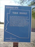 view gallery view galleryW31.1 km | Tubac Schools in Arizona Historical Markers T. Lillie Mercer, Sabino Otero and others established the Tubac town site in 1882, built the Tubac School in 1885, and they organized the Tubac Scouts in 1866 to fight the Apaches. posted by: leadhiker location: Arizona date approved: 05/03/2010 last visited: 09/30/2023 |
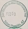 view gallery view galleryW31.1 km |  Juan Bautista de Anza NHT - Tubac Presidio Juan Bautista de Anza NHT - Tubac Presidio
in NPS Passport Cancellation Stations One of many places that has a passport stamp for the Juan Bautista de Anza NHT. This stamp is available behind the counter. I had to show the attendant a stamp for her to understand what I was asking for. posted by: npsVisitor location: Arizona date approved: 03/17/2019 last visited: never |
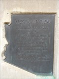 view gallery view galleryW31.1 km | Presidio of Tubac in Arizona Historical Markers Tubac remembers its origins at the Tubac Presidio State Historic Park located in the village's Old Town, and no visit to Tubac is complete without a stop at Arizona's First State Park. posted by: leadhiker location: Arizona date approved: 05/03/2010 last visited: never |
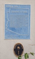 view gallery view galleryW31.1 km |  Churches in Tubac, Arizona Churches in Tubac, Arizona
in Blue Plaques Tubac's most famous Spanish resident was Juan Bautista de Anza. While stationed at Tubac (1760-1776), de Anza built the chapel of Santa Gertrudis, the foundations of which lie beneath today's St. Ann's Church. posted by: grandmabetsy location: Arizona date approved: 12/10/2013 last visited: 09/30/2023 |
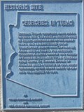 view gallery view galleryW31.1 km | Churches in Tubac in Arizona Historical Markers Tubac's most famous Spanish resident was Juan Bautista de Anza. While stationed at Tubac (1760-1776), de Anza built the chapel of Santa Gertrudis, the foundations of which lie beneath today's St. Ann's Church. posted by: leadhiker location: Arizona date approved: 05/03/2010 last visited: 09/30/2023 |
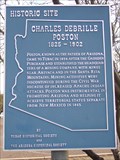 view gallery view galleryW31.2 km | Charles Debrille Poston in Arizona Historical Markers Charles Debrille Poston was an American explorer, prospector, author, politician, and civil servant. He is referred to as the "Father of Arizona" due to his efforts lobbying for creation of the territory. posted by: leadhiker location: Arizona date approved: 05/06/2010 last visited: 09/30/2023 |
|