 view gallery view gallery NW4.2 km NW4.2 km
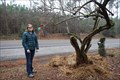
|   Pepper Tree -- SH 21 near Alto TX Pepper Tree -- SH 21 near Alto TX
in Historic Trees A historic pepper tree along the El Camino Real has seen better days, but is hanging on to life with a little help from the Forestry Department of Stephen F. Austin State University posted by:  Benchmark Blasterz Benchmark Blasterz location: Texas date approved: 02/04/2018 last visited: 07/07/2019 |
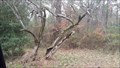 view gallery view galleryNW4.2 km |  Pepper Tree Planted in 1848 Pepper Tree Planted in 1848
in Exceptional Trees On the side of a Texas highway, most likely on a site of a earlier settlement or Mission is a pepper tree marked by a highway sign that reads it was planted well over 150 years ago. posted by: BBQ'n Dadd'n location: Texas date approved: 01/03/2016 last visited: 07/07/2019 |
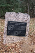
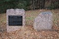 view gallery view galleryNW4.5 km |  El Camino Real -- DAR Marker No. 23 & Mission Santissimo Nombre de Maria -- SH 21 at the Neches River bridge, Cherokee Co. TX El Camino Real -- DAR Marker No. 23 & Mission Santissimo Nombre de Maria -- SH 21 at the Neches River bridge, Cherokee Co. TX
in Wagon Roads and Trails Two historic markers on the west end of the SH 21 bridge over the Neches River along the El Camino Real posted by: Benchmark Blasterz location: Texas date approved: 01/27/2018 last visited: 12/30/2017 |
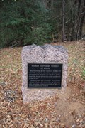
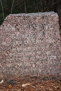
 view gallery view galleryNW4.5 km |  El Camino Real de los Tejas -- DAR Marker No. 23, SH 21 at Neches River El Camino Real de los Tejas -- DAR Marker No. 23, SH 21 at Neches River
in National Scenic Byways No. 23 of 118 pink granite markers erected by the Daughters of The American Revolution and the State of Texas along the route of the Old Spanish Road posted by: Benchmark Blasterz location: Texas date approved: 01/27/2018 last visited: 12/30/2017 |
 view gallery view galleryNW4.5 km | El Camino Real de los Tejas -- Mission Santissimo Nombre de Maria, SH 21 at Neches River in National Scenic Byways A state-accepted historic marker on the west end of the SH 21 bridge over the Neches River along the El Camino Real posted by: Benchmark Blasterz location: Texas date approved: 01/27/2018 last visited: 12/30/2017 |
 view gallery view galleryNW4.5 km |  El Camino Real -- Mission Santissimo Nombre de Maria, SH 21 at Neches River El Camino Real -- Mission Santissimo Nombre de Maria, SH 21 at Neches River
in Ancient Traces and Roads A state-accepted historic marker on the west end of the SH 21 bridge over the Neches River along the El Camino Real posted by: Benchmark Blasterz location: Texas date approved: 01/27/2018 last visited: 12/30/2017 |
 view gallery view galleryNW4.5 km |  King's Highway DAR Marker #23 -- SH 21 at Neches River, Cherokee Co., TX, USA King's Highway DAR Marker #23 -- SH 21 at Neches River, Cherokee Co., TX, USA
in Daughters of the American Revolution No. 23 of 118 pink granite markers erected by the Texas Society of the Daughters of The American Revolution and the State of Texas along the route of the Old Spanish Road from the Louisiana border to the Mexican border posted by: Benchmark Blasterz location: Texas date approved: 05/05/2023 last visited: 05/06/2023 |
 view gallery view galleryNW4.5 km | El Camino Real -- DAR Marker No. 23, SH 21 at Neches River in Ancient Traces and Roads No. 23 of 118 pink granite markers erected by the Daughters of The American Revolution and the State of Texas along the route of the Old Spanish Road posted by: Benchmark Blasterz location: Texas date approved: 01/27/2018 last visited: 12/30/2017 |
 view gallery view galleryNW4.5 km |  King's Highway King's Highway
in Texas Historical Markers No. 23 of 118 pink granite markers erected by the Daughters of The American Revolution and the State of Texas along the route of the Old Spanish Road posted by: Benchmark Blasterz location: Texas date approved: 01/22/2018 last visited: 12/30/2017 |
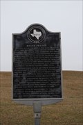
 view gallery view galleryNW4.5 km | Mission Santissimo Nombre de Maria in Texas Historical Markers The state historic marker for the Mission Santissimo Nombre de Maria in Houston County TX posted by: Benchmark Blasterz location: Texas date approved: 11/06/2018 last visited: 12/30/2017 |
 view gallery view gallery N5.8 km N5.8 km
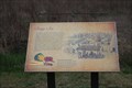
| Mound Prairie -- SH 21 W of Alto TX in Ancient Traces and Roads The state historic marker for Mound Prairie, named for a series of prehistoric Caddo Indian mounds, west of Alto posted by: Benchmark Blasterz location: Texas date approved: 01/27/2018 last visited: 12/30/2017 |
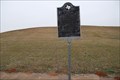 view gallery view galleryN5.8 km | Mound Prairie -- SH 21 W of Alto TX in National Scenic Byways The state historic marker for Mound Prairie, named for a series of prehistoric Caddo Indian mounds, west of Alto posted by: Benchmark Blasterz location: Texas date approved: 01/27/2018 last visited: 12/30/2017 |
 view gallery view galleryN5.8 km | Mound Prairie in Texas Historical Markers The state historic marker for Mound Prairie, named for a series of prehistoric Caddo Indian mounds, west of Alto posted by: Benchmark Blasterz location: Texas date approved: 01/22/2018 last visited: 08/10/2021 |
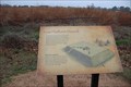
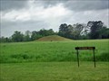
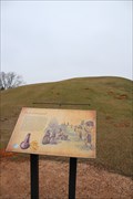
 view gallery view galleryN6 km |  High Temple Mound -- Caddo Mounds SHS, SH 21 W of Alto, TX High Temple Mound -- Caddo Mounds SHS, SH 21 W of Alto, TX
in Signs of History A sign of history for the High Temple Mound at Caddo Mounds State Historic Site west of Alto TX posted by: Benchmark Blasterz location: Texas date approved: 01/22/2018 last visited: 12/30/2017 |
 view gallery view galleryN6 km | Low Platform Mound -- Caddo Mounds SHS, SH 21 W of Alto, TX in Signs of History A sign of history for the Low Platform Mound at Caddo Mounds SHS, SH 21 W of Alto, TX posted by: Benchmark Blasterz location: Texas date approved: 01/22/2018 last visited: 12/30/2017 |
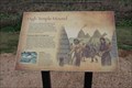
 view gallery view galleryN6.1 km | Village Life -- Caddo Mounds SHS, SH 21 W of Alto, TX in Signs of History The sign of history about Caddo Village Life at Caddo Mounds SHS, SH 21 W of Alto, TX posted by: Benchmark Blasterz location: Texas date approved: 01/22/2018 last visited: 12/30/2017 |
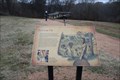 view gallery view galleryN6.1 km | Borrow Pit -- Caddo Mounds SHS, SH 21 est of Alto TX in Signs of History A sign of history for the Borrow Pit at Caddo Mounds State Historic Site west of Alto TX posted by: Benchmark Blasterz location: Texas date approved: 01/22/2018 last visited: 12/30/2017 |
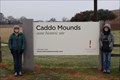 view gallery view galleryN6.3 km |  Caddo Mounds State Historic Site -- Alto TX Caddo Mounds State Historic Site -- Alto TX
in New World Ancient Evidence Unique and FINALLY interpreted Caddo Mounds State Historic Site teaches about the prehistoric Caddo Indians who built tall mounds here. The site is is located along SH 21 west of Alto TX posted by: Benchmark Blasterz location: Texas date approved: 01/22/2018 last visited: 12/30/2017 |
 view gallery view galleryN6.3 km |  Caddo Mounds State Historic Site - Alto, TX Caddo Mounds State Historic Site - Alto, TX
in State/Provincial Parks Unique and FINALLY interpreted Caddo Mounds State Historic Site is located along SH 21 west of Alto TX posted by: Benchmark Blasterz location: Texas date approved: 01/22/2018 last visited: 12/30/2017 |
 view gallery view galleryN6.3 km |  George C. Davis Site Archaeological Excavation – Alto, TX George C. Davis Site Archaeological Excavation – Alto, TX
in WPA Projects The excavation site is now part of the Caddo Mounds State Historic Site. It is located along SH 21 west of Alto. posted by:  WalksfarTX WalksfarTX location: Texas date approved: 03/04/2020 last visited: never |
 view gallery view galleryN6.3 km |  Davis, George C., Site - Alto, TX Davis, George C., Site - Alto, TX
in U.S. National Register of Historic Places The excavation site is now part of the Caddo Mounds State Historic Site. It is located along SH 21 west of Alto. posted by: WalksfarTX location: Texas date approved: 02/27/2020 last visited: never |
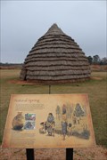 view gallery view galleryN6.3 km | Natural Spring -- Caddo Mounds SHS, SH 21 W of Alto, TX in Signs of History A sign of history at the Natural Spring, Caddo Mounds SHS, SH 21 W of Alto, TX posted by: Benchmark Blasterz location: Texas date approved: 01/22/2018 last visited: 12/30/2017 |
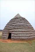 view gallery view galleryN6.3 km |  Caddo Mounds State Historic Site -- Alto TX Caddo Mounds State Historic Site -- Alto TX
in Thatch Cottages Caddo Mounds State Historic Site near Alto TX features a recreation of a prehistoric Caddo Indian hut, roofed with thatches of grass posted by: Benchmark Blasterz location: Texas date approved: 01/23/2018 last visited: 12/30/2017 |
 view gallery view galleryN6.4 km | Burial Mound -- Caddo Mounds SHS, SH 21 W of Alto, TX in Signs of History A sign of history for the Burial Mound at Caddo Mounds State Historic Site west of Alto TX posted by: Benchmark Blasterz location: Texas date approved: 01/22/2018 last visited: 12/30/2017 |
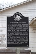 view gallery view galleryN6.4 km | Weeping Mary Community in Texas Historical Markers The state historic marker for the Weeping Mary community near alto posted by: Benchmark Blasterz location: Texas date approved: 01/28/2018 last visited: 12/30/2017 |
|