 view gallery view gallery N1.1 km N1.1 km
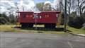
|   L & N Caboose 39 - Evergreen, AL L & N Caboose 39 - Evergreen, AL
in Train Cabooses L & N Caboose 39 is displayed next to the Evergreen Depot. posted by:  hummerstation hummerstation location: Alabama date approved: 04/07/2022 last visited: never |
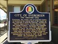 view gallery view galleryN1.1 km |  City of Evergreen (The Emerald City) - Evergreen, AL City of Evergreen (The Emerald City) - Evergreen, AL
in Alabama Historical Markers Marker located right next to the old Evergreen Train Depot near Front Street. The depot has been refurbished and is across from the Evergreen Historic District. posted by:  hoteltwo hoteltwo location: Alabama date approved: 03/12/2015 last visited: 05/05/2024 |
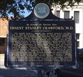 view gallery view galleryN1.3 km | Ernest Stanley Crawford, M.D. - Evergreen, AL in Alabama Historical Markers Located along the railroad tracks in the historic district, this marker notes the life of a renowned vascular surgeon born in this city. posted by: hoteltwo location: Alabama date approved: 03/12/2015 last visited: never |
 view gallery view galleryN1.4 km |  Evergreen Courant - Evergreen, AL Evergreen Courant - Evergreen, AL
in Newspaper Headquarters The Evergreen Courant has been providing the news since 1895 - in Evergreen, Alabama. posted by: The Snowdog location: Alabama date approved: 01/28/2023 last visited: never |
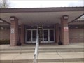
 view gallery view galleryN1.4 km |  Evergreen, AL 36401 Evergreen, AL 36401
in U.S. Post Offices This fine old Post Office serves Evergreen, Alabama. posted by: The Snowdog location: Alabama date approved: 01/28/2023 last visited: never |
 view gallery view gallery NE1.4 km NE1.4 km
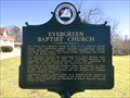
| Evergreen Baptist Church - Evergreen, AL in Alabama Historical Markers Marker located on Park St notes the beginnings of the Evergreen Baptist Church and lists the pastors and lists the pastorates as well. posted by: hoteltwo location: Alabama date approved: 03/12/2015 last visited: never |
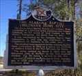 view gallery view galleryNE1.9 km | Alabama Baptist Children’s Home Site - Evergreen, AL in Alabama Historical Markers Former location of widows and orphans home located at the intersection of S. Main St and Cemetery Ave in front of the old Evergreen Junior High School gymnasium. posted by: hoteltwo location: Alabama date approved: 03/22/2015 last visited: 05/05/2024 |
 view gallery view gallery W9.5 km W9.5 km
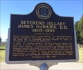
| Reverend Hillary James Hawkins, D.D. (1905-1995) - Lime Hill, AL in Alabama Historical Markers Marker is at the intersection of Brown Hawkins Road and Fall Lane off U.S. Highway 84 and in a small lay by. The street was name after him. Notes his life history in the area. posted by: hoteltwo location: Alabama date approved: 03/12/2015 last visited: never |
 view gallery view gallery SW10.3 km SW10.3 km
|  I-65 SB Conecuh County Rest Area - Castleberry, Alabama I-65 SB Conecuh County Rest Area - Castleberry, Alabama
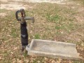
in Hand Operated Water Pumps A Zurn Yard Hydrant in a rest area in Alabama. posted by: theHostas location: Alabama date approved: 04/26/2019 last visited: 03/30/2019 |
 view gallery view gallerySW10.5 km |  I-65 SB Conecuh County Rest Area - Castleberry, Alabama I-65 SB Conecuh County Rest Area - Castleberry, Alabama
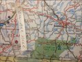
in 'You Are Here' Maps You Are Here in rest area building. posted by: theHostas location: Alabama date approved: 04/25/2019 last visited: 03/30/2019 |
 view gallery view gallerySW10.5 km |  I-65 SB Conecuh, Alabama I-65 SB Conecuh, Alabama
in Highway Rest Areas Rest Area on SB I-65 in Clanton, Kentucky. posted by: theHostas location: Alabama date approved: 04/26/2019 last visited: 03/30/2019 |
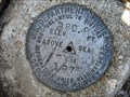 view gallery view gallery S13.8 km S13.8 km
|  US Geological Survey elevation marker 281 FT FAH 1975 US Geological Survey elevation marker 281 FT FAH 1975
in U.S. Benchmarks USGS marker at Holly Grove Church posted by: jkselby location: Alabama date approved: 02/14/2008 last visited: never |
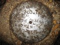
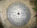 view gallery view galleryS14.8 km | US Geological Survey elevation marker 317.5 FT 7 FAH 1975 in U.S. Benchmarks USGS benchmark at L Pond Church, Conecuh County, AL posted by: jkselby location: Alabama date approved: 03/06/2008 last visited: never |
 view gallery view galleryS15.1 km | US Geological Survey elevation marker 296 FT 6 FAH 1975 in U.S. Benchmarks USGS elevation benchmark at Cedar Creek Church posted by: jkselby location: Alabama date approved: 04/09/2008 last visited: never |
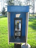
 view gallery view gallerySW17.1 km |  I-65 north rest area phone #1 I-65 north rest area phone #1
in Payphones This is one of two pay phones located just outside the rest area on I-65 northbound in southern Alabama. Maintained by Talton Communications. posted by: Lazer location: Alabama date approved: 10/30/2007 last visited: 01/19/2008 |
 view gallery view gallerySW17.1 km | I-65 north rest area phone #2 in Payphones This is 1 of 2 payphones just outside the I-65 northbound rest area in southern Alabama. Serviced by Talton Communications. posted by: Lazer location: Alabama date approved: 10/30/2007 last visited: 01/19/2008 |
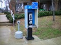 view gallery view gallerySW17.1 km | Northbound I-65 Rest Stop Payphone #3 in Payphones A Payphone located at the northbound I-65 Rest Stop around mile marker 85. posted by: Six Little Spookies location: Alabama date approved: 01/26/2008 last visited: 01/19/2008 |
 view gallery view gallerySW17.1 km | I-65 NB Conecuh County Rest Area - Castleberry, Alabama in 'You Are Here' Maps You Are Here Map in the Conecuh County NB Rest Area building lobby. posted by: theHostas location: Alabama date approved: 04/26/2019 last visited: 04/06/2019 |
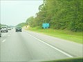 view gallery view gallerySW17.2 km | I-65 Rest Area Mile Marker 58 in Highway Rest Areas A rest area on Interstate 65 North in southern Alabama. posted by: ggmorton location: Alabama date approved: 09/21/2007 last visited: 04/30/2021 |
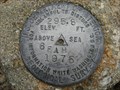
 view gallery view galleryS17.2 km | US Geological Survey elevation marker 288 FT 5 FAH 1975 in U.S. Benchmarks USGS elevation marker near Johnstonville posted by: jkselby location: Alabama date approved: 04/18/2008 last visited: never |
 view gallery view gallery SE20.4 km SE20.4 km
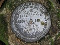
| US Geological Survey elevation marker 304 FT 2 FAH 1975 in U.S. Benchmarks USGS elevation benchmark on County Rd. 6 near Brooklyn posted by: jkselby location: Alabama date approved: 04/18/2008 last visited: never |
 view gallery view gallery NW21.6 km NW21.6 km
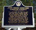
| John Green Cemetery - Burnt Corn, AL in Alabama Historical Markers Located near the community of Burnt Corn, this cemetery contains Civil War and war of 1812 graves. The cemetery is well off the main road and you will need some GPS sense to find it. The cemetery is now well taken care of. posted by: hoteltwo location: Alabama date approved: 03/12/2015 last visited: never |
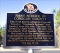 view gallery view galleryNW22.2 km | First School in Conecuh County - Burnt Corn, AL in Alabama Historical Markers Located on Conecuh County Road 15, east of County Road 5 this marker notes the former location of the first school in this rural county. posted by: hoteltwo location: Alabama date approved: 03/22/2015 last visited: never |
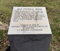 view gallery view galleryW23.3 km | Old Federal Road - Bermuda, AL in Alabama Historical Markers One of eight stone markers along the Alabama portion of the Federal road established as a postal route by President Jefferson. Located at the intersection of County Road 5 and County Road 20. posted by: hoteltwo location: Alabama date approved: 03/24/2015 last visited: never |
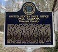 view gallery view gallerySE23.5 km | United States Post Office Paul, Alabama in Alabama Historical Markers This building served as the Paul Post Office from 1908-1975. It is located just south of County Rd 8 on Paul Rd. The former postmaster's home is still right next door. posted by: hoteltwo location: Alabama date approved: 03/06/2021 last visited: never |
|