 view gallery view gallery N9.7 km N9.7 km
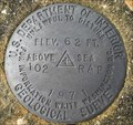
|   U.S. Geological Survey elevation marker 62 FT 102 RAP 1971 U.S. Geological Survey elevation marker 62 FT 102 RAP 1971
in U.S. Benchmarks USGS elevation mark 2.8 miles north of Chrysler, Monroe County posted by:  jkselby jkselby location: Alabama date approved: 11/24/2009 last visited: never |
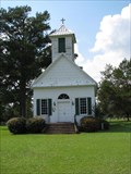
 view gallery view galleryN10.8 km |  Mt. Pleasant Methodist Church - near Uriah, AL Mt. Pleasant Methodist Church - near Uriah, AL
in Alabama Historical Markers Notes the architecture and history of the building of this Methodist Church. It also describes the local industry that sprouted up in the community around this old church. posted by: hoteltwo location: Alabama date approved: 07/17/2024 last visited: never |
 view gallery view gallery NE12.6 km NE12.6 km
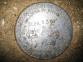
| US Geological Survey elevation marker 136 FT 105 RAP 1971 in U.S. Benchmarks USGS elevation marker on CR 1 near Eliska Church posted by: jkselby location: Alabama date approved: 11/04/2009 last visited: never |
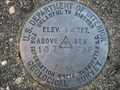 view gallery view galleryNE14.6 km | US Geological Survey elevation marker 147 FT 107 RAP 1971 in U.S. Benchmarks USGS elevation marker at Morning Star Church posted by: jkselby location: Alabama date approved: 11/04/2009 last visited: never |
 view gallery view gallery NW18 km NW18 km
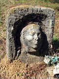
|  Isaac Nettles Gravestones - Carlton, Alabama Isaac Nettles Gravestones - Carlton, Alabama
in Wikipedia Entries Death mask gravestones in Mt. Nebo Baptist Church cemetery near Carlton, Alabama. posted by:  BruceS BruceS location: Alabama date approved: 09/24/2013 last visited: never |
 view gallery view galleryNW18 km |  Nettles, Isaac, Gravestones - Carlton, Alabama Nettles, Isaac, Gravestones - Carlton, Alabama
in U.S. National Register of Historic Places Death mask gravestones in Mt. Nebo Baptist Church cemetery near Carlton, Alabama. posted by: BruceS location: Alabama date approved: 10/31/2009 last visited: never |
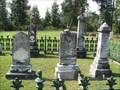
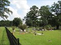
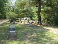 view gallery view galleryNW18 km |  Mt Nebo Baptist Church Cemetery - Carlton, Alabama Mt Nebo Baptist Church Cemetery - Carlton, Alabama
in Worldwide Cemeteries Small churchyard cemetery in rural area near Carlton, Alabama. posted by: BruceS location: Alabama date approved: 11/01/2009 last visited: never |
 view gallery view galleryNW18 km |  Mt Nebo Baptist Church Cemetery - Carlton, Alabama Mt Nebo Baptist Church Cemetery - Carlton, Alabama
in Churchyard Cemeteries Small churchyard cemetery in rural area near Carlton, Alabama. posted by: BruceS location: Alabama date approved: 11/01/2009 last visited: never |
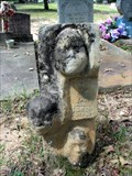
 view gallery view galleryNW18 km |  Mother Nettles - Carlton, Alabama Mother Nettles - Carlton, Alabama
in Death Mask Gravestones Gravestone with three death masks in a rural cemetery in Clarke County, Alabama. posted by: BruceS location: Alabama date approved: 09/25/2009 last visited: never |
 view gallery view galleryNW18 km | Ezella Nettles - Carlton, Alabama in Death Mask Gravestones One of three death mask gravestones in this small cemetery in rural Clarke County, Alabama. posted by: BruceS location: Alabama date approved: 09/25/2009 last visited: never |
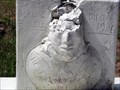 view gallery view galleryNW18 km | Manul Burell - Carlton, Alabama in Death Mask Gravestones One of three death mask gravestones in this small cemetery in rural Clarke County, Alabama. posted by: BruceS location: Alabama date approved: 09/26/2009 last visited: never |
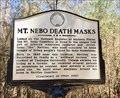 view gallery view galleryNW18 km | Mt. Nebo Death Masks - Carlton, AL in Alabama Historical Markers At the Mt. Nebo Baptist Church, in the nearby cemetery, there are three graves that have very unusual markings. The headstones on these graves contain “death masks”. These headstones were crafted by Isaac Nettles, Sr. (1885 – 1957). posted by: hoteltwo location: Alabama date approved: 03/02/2017 last visited: never |
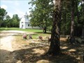
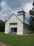
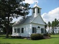
 view gallery view galleryNW18 km |  Mt Nebo Baptist Church - Carlton, Alabama Mt Nebo Baptist Church - Carlton, Alabama
in This Old Church Rural Baptist Church near Carlton, Alabama. posted by: BruceS location: Alabama date approved: 10/31/2009 last visited: never |
 view gallery view galleryNW18 km | Mt Nebo Baptist Church - Carlton, Alabama in Country Churches Rural Baptist Church near Carlton, Alabama. posted by: BruceS location: Alabama date approved: 11/03/2009 last visited: 02/25/2017 |
 view gallery view galleryNW18 km |  Mt. Nebo Baptist Church - Carlton, AL Mt. Nebo Baptist Church - Carlton, AL
in Baptist Churches Rural Baptist Church near Carlton, Alabama. posted by: BruceS location: Alabama date approved: 10/31/2009 last visited: never |
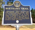 view gallery view galleryNW19.3 km | Bartram's Trail - Rockville, Alabama in Alabama Historical Markers One of many markers noting the trail of William Bartram on his quest for obtaining and documenting natural features of the southern colonies. entrance to the Fred T. Stimpson Wildlife Sanctuary on Rockville Rd. (County Rd 15). posted by: hoteltwo location: Alabama date approved: 03/02/2017 last visited: never |
 view gallery view galleryN20.6 km | Gainestown Methodist Church Cemetery - Gainestown, Alabama in Worldwide Cemeteries Historic cemetery located near the small community of Gainestown, Alabama. posted by: BruceS location: Alabama date approved: 11/04/2009 last visited: never |
 view gallery view galleryN20.6 km | Gainestown Methodist Church and Cemetery - Gainestown, Alabama in Churchyard Cemeteries Historic church and cemetery located near the small community of Gainestown, Alabama. posted by: BruceS location: Alabama date approved: 11/01/2009 last visited: never |
 view gallery view galleryN20.6 km |  Gainestown United Methodist Church - Gainestown, Alabama Gainestown United Methodist Church - Gainestown, Alabama
in Methodist Churches Historic Methodist church located near the small community of Gainestown, Alabama. posted by: BruceS location: Alabama date approved: 10/31/2009 last visited: never |
 view gallery view galleryN20.6 km | Gainestown Methodist Church and Cemetery - Gainestown, Alabama in U.S. National Register of Historic Places Historic church and cemetery located near the small community of Gainestown, Alabama. posted by: BruceS location: Alabama date approved: 10/31/2009 last visited: never |
 view gallery view galleryN20.6 km | Gainestown Methodist Church and Cemetery - Gainestown, Alabama in Wikipedia Entries Historic church and cemetery located near the small community of Gainestown, Alabama. posted by: BruceS location: Alabama date approved: 09/24/2013 last visited: never |
 view gallery view gallery SW21.6 km SW21.6 km
|  Red Hill Spring, Latham, AL Red Hill Spring, Latham, AL
in Artesian Well Red Hill Spring Located on Highway 59 north of Latham, AL. posted by:  Six Little Spookies Six Little Spookies location: Alabama date approved: 01/27/2008 last visited: 11/23/2013 |
 view gallery view gallerySW21.6 km |  Red Hill Spring, Latham, AL Red Hill Spring, Latham, AL
in Natural Springs Natural spring located on Highway 59 north of Latham, AL. posted by: Six Little Spookies location: Alabama date approved: 01/20/2008 last visited: 06/06/2008 |
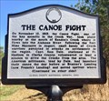 view gallery view galleryN21.7 km | The Canoe Fight - Gainestown, AL in Alabama Historical Markers Marker located along Madison Road (County Road 33), east of Gainestown, describes the Creek War incident between Creek Indians and militiamen of the area forts. posted by: hoteltwo location: Alabama date approved: 03/02/2017 last visited: never |
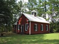 view gallery view galleryN21.7 km |  Gainestown Schoolhouse - Gainestown, Alabama Gainestown Schoolhouse - Gainestown, Alabama
in Former Schools Historic former schoolhouse in the small community of Gainestown, Alabama. posted by: BruceS location: Alabama date approved: 11/04/2009 last visited: never |
|