 view gallery view gallery S4.8 km S4.8 km
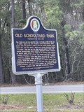
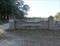
|   Old Schoolyard Park - Historic Stockton Old Schoolyard Park - Historic Stockton
in Alabama Historical Markers Historical marker located in Stockton, AL. posted by:  electrical_chris electrical_chris location: Alabama date approved: 04/22/2023 last visited: 04/22/2023 |
 view gallery view gallery NE5.6 km NE5.6 km
|  Red Hill Spring, Latham, AL Red Hill Spring, Latham, AL
in Natural Springs Natural spring located on Highway 59 north of Latham, AL. posted by:  Six Little Spookies Six Little Spookies location: Alabama date approved: 01/20/2008 last visited: 06/06/2008 |
 view gallery view galleryNE5.6 km |  Red Hill Spring, Latham, AL Red Hill Spring, Latham, AL
in Artesian Well Red Hill Spring Located on Highway 59 north of Latham, AL. posted by: Six Little Spookies location: Alabama date approved: 01/27/2008 last visited: 11/23/2013 |
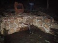
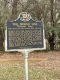 view gallery view galleryS6.3 km | Mound Line in Alabama Historical Markers Historical marker located in Stockton, AL. posted by: electrical_chris location: Alabama date approved: 04/22/2023 last visited: 04/22/2023 |
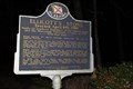
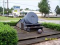 view gallery view galleryS9 km |  13" Mortar - Bay Minette, AL 13" Mortar - Bay Minette, AL
in Static Artillery Displays 13" Mortar located at the Baldwin County Bicentennial Park, Bay Minette, AL posted by: hummerstation location: Alabama date approved: 09/09/2010 last visited: 01/15/2017 |
 view gallery view gallery W14.6 km W14.6 km
|  Southern Railway Depot - Mt. Vernon, AL Southern Railway Depot - Mt. Vernon, AL
in Train Stations/Depots Acquired in 2010 this former train depot is now used by the Mt Vernon Alabama Historical Preservation Society. posted by: hoteltwo location: Alabama date approved: 12/10/2013 last visited: never |
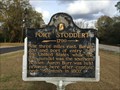 view gallery view galleryW14.8 km | Fort Stoddert (1799) - Mt. Vernon, AL in Alabama Historical Markers Constructed in 1799, Fort Stoddert was located at the Mount Vernon Landing on the Mobile River in Mobile County east of current day Mount Vernon and was named for the Acting Secretary of War Benjamin Stoddert. posted by: hoteltwo location: Alabama date approved: 12/05/2013 last visited: 09/30/2019 |
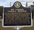 view gallery view galleryW15 km | Mt. Vernon Federal Highway - Mt Vernon, AL in Alabama Historical Markers Describes the history of the establishment of the Federal Highway and other events in Mt. Vernon, Alabama. posted by: hoteltwo location: Alabama date approved: 12/05/2013 last visited: 09/30/2019 |
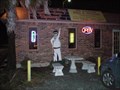 view gallery view galleryW15 km |  Bar-Be-Quing With My Honey - Mt Vernon, AL Bar-Be-Quing With My Honey - Mt Vernon, AL
in Classic BBQ and Sandwich Joints Mom-and-Pop Barbeque restaurant in Mount Vernon, AL on Highway 43. posted by: Six Little Spookies location: Alabama date approved: 01/24/2008 last visited: 10/19/2009 |
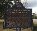 view gallery view galleryW15.6 km | Mount Vernon Arsenal and Barracks - Mt. Vernon, AL in Alabama Historical Markers A small town with a lot of history, this marker describes the history of a nearby former military arsenal. posted by: hoteltwo location: Alabama date approved: 12/06/2013 last visited: never |
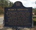 view gallery view galleryW15.6 km | Searcy Hospital - Mt. Vernon, AL in Alabama Historical Markers Searcy Hospital was a state-owned and operated psychiatric hospital. It was located on the grounds of the former Mt. Vernon Arsenal. It closed permanently in 2012 and is now falling into ruin. posted by: hoteltwo location: Alabama date approved: 12/06/2013 last visited: never |
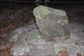
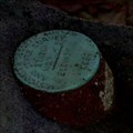 view gallery view galleryW16.3 km |  O 9 ELLICOTT STONE - BH0103 O 9 ELLICOTT STONE - BH0103
in U.S. Benchmarks A U.S. Coast & Geodetic Survey and State Survey disc on top of the Ellicott Stone. posted by: Thorny1 location: Alabama date approved: 07/10/2008 last visited: 09/30/2019 |
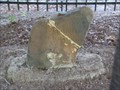 view gallery view galleryW16.3 km |  Ellicott's Stone - Mobile County, AL - US/Spanish Border Marker Ellicott's Stone - Mobile County, AL - US/Spanish Border Marker
in U.S. Historic Survey Stones and Monuments The stone marker, a ferruginous sandstone block about two feet high and eight inches thick, is near the west bank of the Mobile River. On the northern side of the stone is an inscription stating "U.S. Lat. 31, 1799." The inscription on the southern side reads "Dominio De S.M. Carlos IV, Lat. 31, 1799." (Dominion of his majesty King Charles IV, Lat. 31, 1799) posted by: Thorny1 location: Alabama date approved: 07/09/2008 last visited: 09/30/2019 |
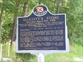 view gallery view galleryW16.4 km | Ellicott's Stone - Mobile County, Alabama in Alabama Historical Markers National boundary between US and Spanish in 1799. posted by: Thorny1 location: Alabama date approved: 07/09/2008 last visited: 09/30/2019 |
 view gallery view galleryW16.4 km |  Ellicott's Stone -- nr Mobile AL Ellicott's Stone -- nr Mobile AL
in Engineering Landmarks In 1968 the American Society of Civil Engineers named the Ellicott Stone a US National Civil Engineering Landmark. posted by: Benchmark Blasterz location: Alabama date approved: 02/14/2015 last visited: 09/30/2019 |
 view gallery view galleryW16.4 km |  FIRST -- Southern Boundary of the US, nr Mobile AL FIRST -- Southern Boundary of the US, nr Mobile AL
in First of its Kind The Ellicott Stone marks the first Southern boundary between the United States and what was, in 1799, Spanish Florida. It also serves as the initial point (or Zero Stone) for all public land surveys in the Mississippi territory. posted by: Benchmark Blasterz location: Alabama date approved: 02/13/2015 last visited: 09/30/2019 |
 view gallery view galleryW16.4 km | FIRST -- Survey Point for Public Lands in Mississippi Territory, nr Mobile AL in First of its Kind The Ellicott Stone serves as the initial point (or Zero Stone) for all public land surveys in the Mississippi territory. posted by: Benchmark Blasterz location: Alabama date approved: 02/13/2015 last visited: 09/30/2019 |
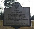 view gallery view gallery SW18.7 km SW18.7 km
| Site of Old Mobile in Alabama Historical Markers Marks the nearby location of the French Fort Louis de la Louisiane built in 1702. posted by: hoteltwo location: Alabama date approved: 12/05/2013 last visited: never |
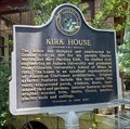 view gallery view gallerySW20.6 km | Kirk House - Axis, Alabama in Alabama Historical Markers The Kirk family beginnings in the area started with saw mills. Ancestors still live in the house and it is open for events and tours. posted by: hoteltwo location: Alabama date approved: 07/09/2023 last visited: never |
 view gallery view gallery SE20.8 km SE20.8 km
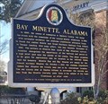
| Bay Minette, Alabama in Alabama Historical Markers Marker about the history of Bay Minette is located at the Bay Minette Public Library, 205 W 2nd Street. posted by: hoteltwo location: Alabama date approved: 01/17/2017 last visited: never |
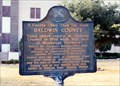 view gallery view gallerySE20.8 km | A County Older Than the State-Baldwin County in Alabama Historical Markers At the courthouse in Bay Minette. posted by: Markerman62 location: Alabama date approved: 04/07/2015 last visited: 01/14/2017 |
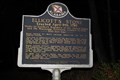
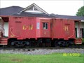 view gallery view galleryS20.9 km |  L & N Caboose 114 - Bay Minette, AL L & N Caboose 114 - Bay Minette, AL
in Train Cabooses L & N Caboose 114 located at the Chamber of Commerce in Bay Minette, AL posted by: hummerstation location: Alabama date approved: 08/31/2010 last visited: never |
 view gallery view gallerySW24.1 km |  Charles Hudgens - Creola Cemetery - Creola, AL Charles Hudgens - Creola Cemetery - Creola, AL
in Woodmen of the World Grave Markers/Monuments The Charles Hudgens Woodmen of the World memorial is located in the Creola Cemetery. posted by: hummerstation location: Alabama date approved: 01/27/2019 last visited: never |
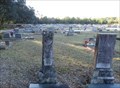
 view gallery view gallerySW24.1 km |  Creola Cemetery - Creola, AL Creola Cemetery - Creola, AL
in Worldwide Cemeteries Creola Cemetery is located behind the Creola United Methodist Church off of Highway 43 and on James Burkett Lane. posted by: hummerstation location: Alabama date approved: 01/28/2019 last visited: never |
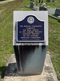 view gallery view gallery E26.1 km E26.1 km
| Old Sullivan Community Cemetery - Atmore, AL in Alabama Historical Markers Located at 287 James Rd about 7 mi W of Atmore at Sullivan Cemetery, the marker notes its addition to the Alabama Register of Historic Cemeteries. posted by: hoteltwo location: Alabama date approved: 07/15/2023 last visited: never |
|