 view gallery view gallery E2.9 km E2.9 km
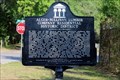
|   Old Sullivan Community Cemetery - Atmore, AL Old Sullivan Community Cemetery - Atmore, AL
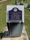
in Alabama Historical Markers Located at 287 James Rd about 7 mi W of Atmore at Sullivan Cemetery, the marker notes its addition to the Alabama Register of Historic Cemeteries. posted by:  hoteltwo hoteltwo location: Alabama date approved: 07/15/2023 last visited: never |
 view gallery view galleryE12.9 km | Railroad Bill - Atmore, AL in Alabama Historical Markers Located on East Louisiana Avenue near North Pensacola Avenue at the train station, Atmore posted by:  Markerman62 Markerman62 location: Alabama date approved: 07/07/2022 last visited: never |
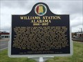 view gallery view galleryE12.9 km | Williams Station, Alabama (1866-1897) - Atmore, AL in Alabama Historical Markers Marker near the old Atmore train station on Highway 31, notes the early history of Atmore and the railroad influence. posted by: hoteltwo location: Alabama date approved: 04/02/2014 last visited: 09/26/2015 |
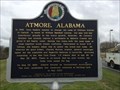 view gallery view galleryE12.9 km | Atmore, Alabama in Alabama Historical Markers Marker located on East Nashville Ave in downtown Atmore describes the beginnings of the city and a little of its history. posted by: hoteltwo location: Alabama date approved: 04/02/2014 last visited: 03/05/2023 |
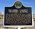 view gallery view galleryE14.3 km | Escambia County Training School - Atmore, AL in Alabama Historical Markers Marker notes the history and sports records of the historically African-American school buildings located here on Martin Luther King Avenue (formerly 8th Avenue) between Broad & McGlasker Streets. posted by: hoteltwo location: Alabama date approved: 01/17/2017 last visited: never |
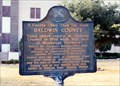 view gallery view gallery SW19.8 km SW19.8 km
| A County Older Than the State-Baldwin County in Alabama Historical Markers At the courthouse in Bay Minette. posted by: Markerman62 location: Alabama date approved: 04/07/2015 last visited: 01/14/2017 |
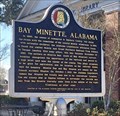 view gallery view gallerySW20.1 km | Bay Minette, Alabama in Alabama Historical Markers Marker about the history of Bay Minette is located at the Bay Minette Public Library, 205 W 2nd Street. posted by: hoteltwo location: Alabama date approved: 01/17/2017 last visited: never |
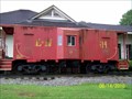 view gallery view gallerySW20.8 km |  L & N Caboose 114 - Bay Minette, AL L & N Caboose 114 - Bay Minette, AL
in Train Cabooses L & N Caboose 114 located at the Chamber of Commerce in Bay Minette, AL posted by: hummerstation location: Alabama date approved: 08/31/2010 last visited: never |
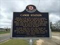 view gallery view galleryE20.8 km | Canoe Station - Canoe, AL in Alabama Historical Markers Marker along Highway 31 near Atmore, notes the early settlement of rural area initially important during the Civil War and for its mineral springs. posted by: hoteltwo location: Alabama date approved: 04/02/2014 last visited: 02/16/2015 |
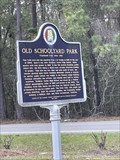 view gallery view gallery W21.2 km W21.2 km
| Old Schoolyard Park - Historic Stockton in Alabama Historical Markers Historical marker located in Stockton, AL. posted by: electrical_chris location: Alabama date approved: 04/22/2023 last visited: 04/22/2023 |
 view gallery view gallery NW21.7 km NW21.7 km
|  Red Hill Spring, Latham, AL Red Hill Spring, Latham, AL
in Natural Springs Natural spring located on Highway 59 north of Latham, AL. posted by: Six Little Spookies location: Alabama date approved: 01/20/2008 last visited: 06/06/2008 |
 view gallery view galleryNW21.7 km |  Red Hill Spring, Latham, AL Red Hill Spring, Latham, AL
in Artesian Well Red Hill Spring Located on Highway 59 north of Latham, AL. posted by: Six Little Spookies location: Alabama date approved: 01/27/2008 last visited: 11/23/2013 |
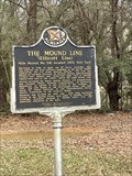 view gallery view galleryW22 km | Mound Line in Alabama Historical Markers Historical marker located in Stockton, AL. posted by: electrical_chris location: Alabama date approved: 04/22/2023 last visited: 04/22/2023 |
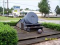 view gallery view galleryW23.5 km |  13" Mortar - Bay Minette, AL 13" Mortar - Bay Minette, AL
in Static Artillery Displays 13" Mortar located at the Baldwin County Bicentennial Park, Bay Minette, AL posted by: hummerstation location: Alabama date approved: 09/09/2010 last visited: 01/15/2017 |
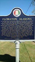 view gallery view galleryE34.6 km | Flomaton, Alabama-Flomaton, AL in Alabama Historical Markers Flomation AL town created by the railroads. posted by: Don.Morfe location: Alabama date approved: 10/12/2017 last visited: 10/29/2021 |
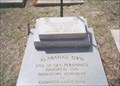
 view gallery view galleryE34.6 km |  Alabama's own Alabama's own
in Specific Veteran Memorials A World War I memorial dedicated to one of Alabama's own. posted by: Lazer location: Alabama date approved: 10/15/2007 last visited: 02/16/2015 |
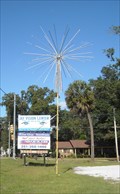 view gallery view galleryE34.6 km |  Black Cat Fireworks stand in Flomaton, AL Black Cat Fireworks stand in Flomaton, AL
in Fireworks Trees This tree looked in good repair but on Halloween, it wasn't on. posted by: TKDenizen location: Alabama date approved: 11/04/2010 last visited: 02/16/2015 |
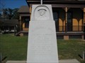
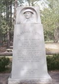 view gallery view galleryE34.6 km |  Alabama's Own-Flomaton, AL Alabama's Own-Flomaton, AL
in World War I Memorials and Monuments Alabama's Own-Corporal Sidney E. Manning, WWI Medal of Honor Recipient, one of General Pershing's Immortal Ten. posted by: Don.Morfe location: Alabama date approved: 10/03/2017 last visited: 10/23/2021 |
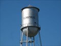 view gallery view galleryE34.8 km |  Flomaton Tower Flomaton Tower
in Water Towers A small tower serving residents of the town of Flomaton, AL. posted by: Lazer location: Alabama date approved: 10/14/2007 last visited: 02/16/2015 |
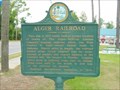 view gallery view galleryE34.9 km |  Alger Railroad / Century, Florida Alger Railroad / Century, Florida
in Florida Historical Markers A double marker with history about the local railroad and the town that the railroad work created. posted by: ggmorton location: Florida date approved: 10/16/2007 last visited: 05/08/2018 |
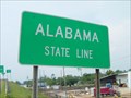 view gallery view galleryE34.9 km |  Florida Alabama Line - Century, FL Florida Alabama Line - Century, FL
in Border Crossings The Florida Alabama state line in Century, Florida. posted by: ggmorton location: Alabama date approved: 11/20/2007 last visited: 02/16/2015 |
 view gallery view galleryE35.4 km | Sidney Earnest Manning-Flomaton, AL in Medal Of Honor Resting Places World War I Medal of Honor Recipient for action near Breuvannes, France on July 28, 1918. He is buried in Little Escambia Baptist Church Cemetery, Flomaton AL. posted by: Don.Morfe location: Alabama date approved: 10/09/2017 last visited: 12/19/2021 |
 view gallery view galleryE35.6 km | Alger-Sullivan Lumber Company Residential Historic District in Florida Historical Markers Located at Jefferson Ave and Front St posted by: Markerman62 location: Florida date approved: 05/09/2018 last visited: 05/08/2019 |
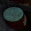 view gallery view galleryW37.7 km |  O 9 ELLICOTT STONE - BH0103 O 9 ELLICOTT STONE - BH0103
in U.S. Benchmarks A U.S. Coast & Geodetic Survey and State Survey disc on top of the Ellicott Stone. posted by: Thorny1 location: Alabama date approved: 07/10/2008 last visited: 09/30/2019 |
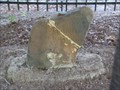 view gallery view galleryW37.7 km |  Ellicott's Stone - Mobile County, AL - US/Spanish Border Marker Ellicott's Stone - Mobile County, AL - US/Spanish Border Marker
in U.S. Historic Survey Stones and Monuments The stone marker, a ferruginous sandstone block about two feet high and eight inches thick, is near the west bank of the Mobile River. On the northern side of the stone is an inscription stating "U.S. Lat. 31, 1799." The inscription on the southern side reads "Dominio De S.M. Carlos IV, Lat. 31, 1799." (Dominion of his majesty King Charles IV, Lat. 31, 1799) posted by: Thorny1 location: Alabama date approved: 07/09/2008 last visited: 09/30/2019 |
|