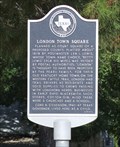
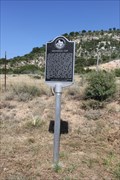
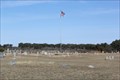
 view gallery view gallery N0.2 km N0.2 km
|   London Town Square London Town Square
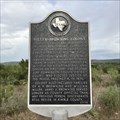
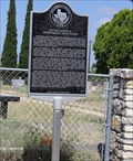
in Texas Historical Markers The state historic marker at the London Town Square, intended to be the seat of Kimble County when it was laid out in 1878. posted by:  Benchmark Blasterz Benchmark Blasterz location: Texas date approved: 10/20/2015 last visited: 07/25/2015 |
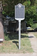 view gallery view galleryN0.2 km |  London TX London TX
in Small Town, Big Name Tiny London was laid out to be the seat of Kimble County in 1878 -- when Junction was named county seat, London's fate was sealed posted by: Benchmark Blasterz location: Texas date approved: 10/12/2015 last visited: 07/24/2015 |
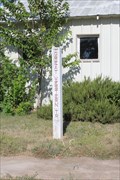 view gallery view galleryN0.2 km |  The Great Western Cattle Trail -- London TX The Great Western Cattle Trail -- London TX
in Wagon Roads and Trails A concrete pole Great Western Trail marker in front of the London TX City Hall reminds that 140 years ago, cattle drives passed through here on the way to markets in the north. posted by: Benchmark Blasterz location: Texas date approved: 10/28/2015 last visited: 08/01/2015 |
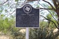
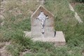
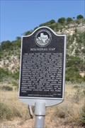 view gallery view gallery S2.9 km S2.9 km
| Reichenau Gap in Texas Historical Markers The historic marker at the Reichenau Gap, in Kimble County south of London. posted by: Benchmark Blasterz location: Texas date approved: 10/20/2015 last visited: 07/25/2015 |
 view gallery view galleryS2.9 km |  Reichenau Gap -- US 377 south of London TX Reichenau Gap -- US 377 south of London TX
in Named Mountain Gaps The historic marker at the Reichenau Gap, a famous pioneer-era mountain gap in Kimble County, south of London. posted by: Benchmark Blasterz location: Texas date approved: 10/08/2015 last visited: 07/24/2015 |
 view gallery view gallery SW17.9 km SW17.9 km
| Teacup Mountain in Texas Historical Markers The historic marker for Teacup Mountain, an important local landform easily seen from the US 377 north of Junction posted by: Benchmark Blasterz location: Texas date approved: 10/19/2015 last visited: 07/25/2015 |
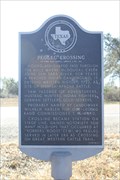 view gallery view galleryN21.6 km | Pegleg Crossing on the San Saba in Texas Historical Markers The state historic marker for the Pegleg crossing in San Saba is located at a roadside pullout on State Highway 29. posted by: Benchmark Blasterz location: Texas date approved: 01/20/2017 last visited: 06/09/2017 |
 view gallery view galleryN21.6 km | Great Western Trail -- Pegleg Crossing on the San Saba, SH 29, Menard Co. TX in Wagon Roads and Trails The Great Western Trail used the Pegleg Crossing on the San Saba as part of the cattle route north to Canada posted by: Benchmark Blasterz location: Texas date approved: 01/10/2017 last visited: 06/09/2017 |
 view gallery view galleryN21.6 km |  Pegleg Crossing on the San Saba -- SH 29, Menard Co. TX Pegleg Crossing on the San Saba -- SH 29, Menard Co. TX
in Battlefields In 1732 Spanish troops and Apache Indians clashed in a battle near here where McDougall Creek joins the San Saba River posted by: Benchmark Blasterz location: Texas date approved: 01/13/2017 last visited: 06/09/2017 |
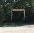 view gallery view galleryN21.7 km |  76848 -- Hext TX 76848 -- Hext TX
in U.S. Post Offices Almost a ghost town, the tiny Texas town of Hext still has a US post office posted by: Benchmark Blasterz location: Texas date approved: 10/19/2015 last visited: 07/24/2015 |
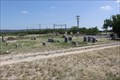
 view gallery view galleryN22.4 km |  Hext Cemetery -- Hext TX Hext Cemetery -- Hext TX
in Worldwide Cemeteries The tiny town of Hext in Menard County has more folks in the cemetery than in town posted by: Benchmark Blasterz location: Texas date approved: 01/08/2017 last visited: 01/09/2017 |
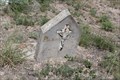
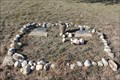 view gallery view galleryN22.4 km |  A Latin American Child and a Latin American Infant -- Hext Cemetery, Hext TX A Latin American Child and a Latin American Infant -- Hext Cemetery, Hext TX
in Graves of the Unknown The graves of an unknown Latin American child and an unknown Latin American Infant at Hext Cemetery are touchingly lined with stones, lights, and both a handmade tombstone and a traditional tombstone posted by: Benchmark Blasterz location: Texas date approved: 01/07/2017 last visited: 01/09/2017 |
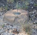 view gallery view galleryN22.5 km |  BN0785 Hext -- Hext, TX BN0785 Hext -- Hext, TX
in U.S. Benchmarks A triangulation station on the TX SH 29 near the tiny Menard Co. town of Hext, where the Benchmark Blasterz completed the Texas County Challenge (Benchmark Mode) on 24 July 2015 -- and with an FTF no less :) posted by: Benchmark Blasterz location: Texas date approved: 10/05/2015 last visited: 07/22/2015 |
 view gallery view gallerySW23.5 km | Cloud Point in Texas Historical Markers This post-mounted subject marker stands to the immediate left of the "Miller-Browning Colony" marker on FM 2169 a few miles east of Junction, TX. posted by: QuesterMark location: Texas date approved: 09/19/2020 last visited: 08/13/2021 |
 view gallery view gallerySW23.5 km | Miller-Browning Colony in Texas Historical Markers This post-mounted subject marker stands to the immediate right of the "Cloud Point" marker on FM 2169 a few miles east of Junction, TX. posted by: QuesterMark location: Texas date approved: 09/20/2020 last visited: 08/13/2021 |
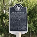 view gallery view gallerySW25.1 km | The Oliver Pecan in Texas Historical Markers This post-mounted subject marker from 1973 stands on the south side of the road at 1843 FM 2169, Junction, TX 76849 (address via Google Maps). The post appears to have been repaired via sleeving in another post. posted by: QuesterMark location: Texas date approved: 09/21/2020 last visited: never |
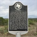
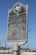
 view gallery view gallerySW25.9 km | First Court in Kimble County in Texas Historical Markers This historic marker details the history of the first courthouse in Kimble County, not far from here. posted by: Benchmark Blasterz location: Texas date approved: 10/18/2015 last visited: 07/24/2015 |
 view gallery view gallerySW25.9 km |  FIRST -- Court session in Kimble County, near Junction TX FIRST -- Court session in Kimble County, near Junction TX
in First of its Kind The first court session in Kimble County was held under a large live oak tree with bees bizzing around it on the banks of the North Llano River posted by: Benchmark Blasterz location: Texas date approved: 10/07/2015 last visited: 07/24/2015 |
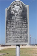 view gallery view gallerySW25.9 km | The Killing of Sam Speer in Texas Historical Markers This historic marker detailing the death of Sam Speer, killed by Indians in 1876 posted by: Benchmark Blasterz location: Texas date approved: 10/18/2015 last visited: 07/24/2015 |
 view gallery view gallerySW25.9 km |  LAST -- Anglo settler killed by Indians in Kimble Co., Junction TX LAST -- Anglo settler killed by Indians in Kimble Co., Junction TX
in Last of its Kind This historic marker detailing the death of Sam Speer, killed by Indians in 1876 -- the last Indian murder of an Anglo settler in Kimble county posted by: Benchmark Blasterz location: Texas date approved: 10/07/2015 last visited: 07/23/2015 |
 view gallery view gallerySW26.1 km |  OST through Little Mexico (Northeast Junction) - Junction, TX OST through Little Mexico (Northeast Junction) - Junction, TX
in Old Spanish Trail Auto Route The state historic marker at Cementerio Campo Santo, also known as Little Mexico Cemetery, in Junction TX discusses the impact of the OST on this separated and segregated community near Junction. posted by: Benchmark Blasterz location: Texas date approved: 10/07/2015 last visited: 07/23/2015 |
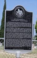 view gallery view gallerySW26.1 km | Little Mexico (Northeast Junction) in Texas Historical Markers The state historic marker at Cementerio Campo Santo, also known as Little Mexico Cemetery in Junction TX posted by: Benchmark Blasterz location: Texas date approved: 10/19/2015 last visited: 07/24/2015 |
 view gallery view gallerySW26.1 km | Cementario Campo Santo/Little Mexico Cemetery -- Junction TX in Worldwide Cemeteries Depending on your ethnicity, you would call this cemetery near the I-10 in Junction TX either Cementerio Campo Santo or Little Mexico Cemetery. posted by: Benchmark Blasterz location: Texas date approved: 10/07/2015 last visited: 07/23/2015 |
 view gallery view gallerySW26.1 km |  Damial de Luna -- Cementario Campo Santo/Little Mexico Cemetery, Junction TX Damial de Luna -- Cementario Campo Santo/Little Mexico Cemetery, Junction TX
in Homemade Tombstones The homemade tombstone for Damial de Luna, in Northeast Junction's historic Cementario Campo Santo, one of two made by the same person at the same time posted by: Benchmark Blasterz location: Texas date approved: 10/07/2015 last visited: 07/23/2015 |
 view gallery view gallerySW26.1 km | Augelio Sauseda -- Cementario Campo Santo/Little Mexico Cemetery, Junction TX in Homemade Tombstones The homemade tombstone for Augelio Sauseda, in Northeast Junction's historic Cementario Campo Santo, one of two made by the same person at the same time posted by: Benchmark Blasterz location: Texas date approved: 10/07/2015 last visited: 07/23/2015 |
|