 view gallery view gallery NW2.3 km NW2.3 km
|   Donkey Lady Bridge - Medina River Natural Area, San Antonio, TX USA Donkey Lady Bridge - Medina River Natural Area, San Antonio, TX USA
in Weird Story Locations The Donkey Lady Bridge is found near the Medina River Greenway Applewhite Trailhead at 2440 W. Jett Road, San Antonio, Texas 78264. Also described as at the Old Applewhite Trailhead. posted by:  WayBetterFinder WayBetterFinder location: Texas date approved: 02/24/2023 last visited: 02/24/2023 |
 view gallery view gallery W2.7 km W2.7 km
|  Oak Island Cemetery - San Antonio, TX Oak Island Cemetery - San Antonio, TX
in Worldwide Cemeteries Cemetery is adjacent to Oak Island United Methodist Church. Pictured on "Find a Grave" website with an arched entrance. The arch is now gone. posted by:  WalksfarTX WalksfarTX location: Texas date approved: 09/20/2018 last visited: never |
 view gallery view galleryW2.7 km |  Oak Island Methodist Church - San Antonio, TX Oak Island Methodist Church - San Antonio, TX
in Methodist Churches Oak Island is near the Medina River off State Highway 16, fifteen miles south of downtown San Antonio in southern Bexar County. In 1878 John Wesley DeVilbiss established a Methodist mission church here. New sanctuary sits next to the original church. posted by: WalksfarTX location: Texas date approved: 09/22/2018 last visited: 09/27/2021 |
 view gallery view galleryW2.7 km |  Oak Island Methodist Church - San Antonio, TX Oak Island Methodist Church - San Antonio, TX
in This Old Church Oak Island is near the Medina River off State Highway 16, fifteen miles south of downtown San Antonio in southern Bexar County. In 1878 John Wesley DeVilbiss established a Methodist mission church here. posted by: WalksfarTX location: Texas date approved: 09/21/2018 last visited: 09/27/2021 |
 view gallery view galleryW2.7 km |  1 - Oak Island Church - San Antonio, TX 1 - Oak Island Church - San Antonio, TX
in Historic United Methodist Sites Oak Island is near the Medina River off State Highway 16, fifteen miles south of downtown San Antonio in southern Bexar County. In 1878 John Wesley DeVilbiss established a Methodist mission church here. posted by: WalksfarTX location: Texas date approved: 09/20/2018 last visited: 09/27/2021 |
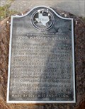 view gallery view galleryW2.7 km |  Oak Island Methodist Church and Cemetery with Grave of the Reverend John Wesly DeVilbliss Oak Island Methodist Church and Cemetery with Grave of the Reverend John Wesly DeVilbliss
in Texas Historical Markers Texas Historical Marker Mounted on a Large stone in front of Methodist Church landmark building, in Oak Island Texas. posted by: SoloSeekers ヅ location: Texas date approved: 05/25/2013 last visited: 09/27/2021 |
 view gallery view galleryW2.7 km |  Oak Island Methodist Church - San Antonio, TX Oak Island Methodist Church - San Antonio, TX
in Bells On display on a rock pedestal to the right of the old church building. posted by: WalksfarTX location: Texas date approved: 09/20/2018 last visited: 09/27/2021 |
 view gallery view galleryNW5 km |  Old Farmhouse Chimney - San Antonio, TX Old Farmhouse Chimney - San Antonio, TX
in Lonely Chimneys Chimney is along the paved trail in the Medina River Natural Area. posted by: WalksfarTX location: Texas date approved: 01/25/2020 last visited: never |
 view gallery view galleryNW5.5 km |  Medina River Park Trailhead - San Antonio, TX Medina River Park Trailhead - San Antonio, TX
in 'You Are Here' Maps Map is at trailhead near the ranger station. posted by: WalksfarTX location: Texas date approved: 01/26/2020 last visited: never |
 view gallery view gallery NE5.5 km NE5.5 km
|  El Camino Real -- DAR Marker No. 88, 16030 Pleasanton Rd, San Antonio TX El Camino Real -- DAR Marker No. 88, 16030 Pleasanton Rd, San Antonio TX
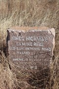
in Wagon Roads and Trails No. 88 of 128 pink granite El Camino Real markers placed by the Daughters of the American Revolution in 1918 stands on the route of the Old San Antonio Road in a backyard, San Antonio TX posted by: Benchmark Blasterz location: Texas date approved: 04/08/2018 last visited: 01/14/2018 |
 view gallery view galleryNE5.5 km | King's Highway in Texas Historical Markers No. 88 of 128 pink granite markers erected by the Daughters of The American Revolution and the State of Texas along the route of the Old Spanish Road posted by: Benchmark Blasterz location: Texas date approved: 02/13/2018 last visited: 01/14/2018 |
 view gallery view galleryNE5.5 km |  El Camino Real de los Tejas -- DAR Marker No. 88, 16029 Pleasanton Rd, San Antonio TX El Camino Real de los Tejas -- DAR Marker No. 88, 16029 Pleasanton Rd, San Antonio TX
in National Scenic Byways No. 88 of 128 pink granite El Camino Real markers placed by the Daughters of the American Revolution in 1918 stands on the route of the Old San Antonio Road in a backyard, San Antonio TX posted by: Benchmark Blasterz location: Texas date approved: 02/05/2018 last visited: 01/14/2018 |
 view gallery view galleryNE5.5 km |  El Camino Real -- DAR Marker No. 88, 16029 Pleasanton Rd, San Antonio TX El Camino Real -- DAR Marker No. 88, 16029 Pleasanton Rd, San Antonio TX
in Ancient Traces and Roads No. 88 of 128 pink granite El Camino Real markers placed by the Daughters of the American Revolution in 1918 stands on the route of the Old San Antonio Road in a backyard, San Antonio TX posted by: Benchmark Blasterz location: Texas date approved: 02/04/2018 last visited: 01/14/2018 |
 view gallery view galleryNE5.5 km |  King's Highway DAR Marker #88 -- 16029 Pleasanton Rd/old US 281, Bexar Co., TX, USA King's Highway DAR Marker #88 -- 16029 Pleasanton Rd/old US 281, Bexar Co., TX, USA
in Daughters of the American Revolution No. 88 of 118 pink granite markers erected by the Texas Society of the Daughters of The American Revolution and the State of Texas along the route of the Old Spanish Road from the Louisiana border to the Mexican border posted by: Benchmark Blasterz location: Texas date approved: 05/05/2023 last visited: 05/06/2023 |
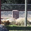
 view gallery view galleryNE5.6 km |  Pleasanton Road bridge over the Medina River -- Bexar Co. TX Pleasanton Road bridge over the Medina River -- Bexar Co. TX
in Orphaned Bridges The old Pleasanton/US 281 bridge, a state-of-the-art marvel of concrete engineering when it opened in 1910, and a dangerously obsolete death-risk when closed in the 1970s. posted by: Benchmark Blasterz location: Texas date approved: 02/05/2018 last visited: 01/14/2018 |
 view gallery view galleryNW5.6 km |  Medina River Natural Area - San Antonio, TX Medina River Natural Area - San Antonio, TX
in Municipal Parks and Plazas 511-acre oasis with riverfront paved & dirt hiking & biking trails, with a variety of terrain & wildlife. posted by: WalksfarTX location: Texas date approved: 01/26/2020 last visited: never |
 view gallery view gallery E6.1 km E6.1 km
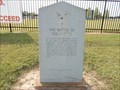
| The Battle Of The Medina in Texas Historical Markers This is the oldest of several markers that claim The Battle of the Medina was fought at its location. In 1936, when this marker was placed, that was the belief at the time. Since then, other research places the battle a few miles southward from here. posted by: WayBetterFinder location: Texas date approved: 09/11/2021 last visited: 09/11/2021 |
 view gallery view gallery N6.3 km N6.3 km
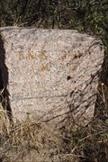
|  AY0801 - X510 - 1953 AY0801 - X510 - 1953
in U.S. Benchmarks Literally "down a long country road," near the fence along the south side of the roadway. posted by: WayBetterFinder location: Texas date approved: 07/31/2015 last visited: 08/01/2015 |
 view gallery view galleryNE7.1 km | King's Highway in Texas Historical Markers No. 87 of 128 pink granite markers erected by the Daughters of The American Revolution and the State of Texas along the route of the Old Spanish Road posted by: Benchmark Blasterz location: Texas date approved: 02/12/2018 last visited: 01/14/2018 |
 view gallery view galleryNE7.1 km | El Camino Real -- DAR Marker No. 87, Pleasanton Rd N of Mauermann Rd, San Antonio TX in Wagon Roads and Trails No. 87 of 128 pink granite El Camino Real markers placed by the Daughters of the American Revolution in 1918 stands on the route of the Old San Antonio Road along Pleasanton Rd N of Mauermann Rd, San Antonio TX posted by: Benchmark Blasterz location: Texas date approved: 02/04/2018 last visited: 01/14/2018 |
 view gallery view galleryNE7.1 km | El Camino Real -- DAR Marker No. 87, Pleasanton Rd N of Mauermann Rd, San Antonio TX in Ancient Traces and Roads No. 87 of 128 pink granite El Camino Real markers placed by the Daughters of the American Revolution in 1918 stands on the route of the Old San Antonio Road along Pleasanton Rd N of Mauermann Rd, San Antonio TX posted by: Benchmark Blasterz location: Texas date approved: 02/04/2018 last visited: 05/22/2019 |
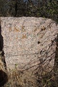 view gallery view galleryNE7.1 km | El Camino Real de los Tejas -- DAR Marker No. 87, Pleasanton Rd N of Mauermann Rd, San Antonio TX in National Scenic Byways No. 87 of 128 pink granite El Camino Real markers placed by the Daughters of the American Revolution in 1918 stands on the route of the Old San Antonio Road along Pleasanton Rd N of Mauermann Rd, San Antonio TX posted by: Benchmark Blasterz location: Texas date approved: 02/05/2018 last visited: 01/14/2018 |
 view gallery view galleryNE7.1 km | King's Highway DAR Marker #87 -- Old US 281/Pleasanton Rd N of Mauermann Rd, San Antonio, TX, USA in Daughters of the American Revolution No. 87 of 118 pink granite markers erected by the Texas Society of the Daughters of The American Revolution and the State of Texas along the route of the Old Spanish Road from the Louisiana border to the Mexican border posted by: Benchmark Blasterz location: Texas date approved: 05/05/2023 last visited: 05/06/2023 |
 view gallery view gallery SE7.9 km SE7.9 km
| King's Highway DAR Marker #89 -- Old US281/Pleasanton Rd at Osburn Sand Co. Rd, Bexar Co., TX, USA in Daughters of the American Revolution No. 89 of 118 pink granite markers erected by the Texas Society of the Daughters of The American Revolution and the State of Texas along the route of the Old Spanish Road from the Louisiana border to the Mexican border posted by: Benchmark Blasterz location: Texas date approved: 05/05/2023 last visited: 05/06/2023 |
 view gallery view gallerySE7.9 km | El Camino Real -- DAR Marker No. 89, Pleasanton Rd at Osburn Sand Co. Rd, San Antonio TX in Wagon Roads and Trails No. 89 of 128 pink granite El Camino Real markers placed by the Daughters of the American Revolution in 1918 stands on the route of the Old San Antonio Road along Pleasanton Road at Osburn Sand Road posted by: Benchmark Blasterz location: Texas date approved: 02/04/2018 last visited: 01/14/2018 |
|