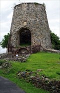
 view gallery view gallery NW2.9 km NW2.9 km
|   Annaberg Sugar Plantation - St. john U.S.V.I. Annaberg Sugar Plantation - St. john U.S.V.I.
in Windmills The 40 foot windmill could be rotated to catch prevailing winds, not limited to one position. posted by:  kJfishman kJfishman location: US Virgin Islands date approved: 12/16/2016 last visited: 07/04/2022 |
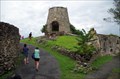 view gallery view galleryNW2.9 km |  Annaberg Sugar Plantation Ruins - St. john U.S.V.I. Annaberg Sugar Plantation Ruins - St. john U.S.V.I.
in Preserved Architectural Remnants and Ruins This Sugar Cane Plant was constructed between 1797 and 1805. It was state of the art at the time. The 40 foot windmill could be rotated to catch prevailing winds, not limited to one position. The plant was operated by slaves and the island and was a colony Denmark at that time the United States purchased them. posted by: kJfishman location: US Virgin Islands date approved: 11/13/2016 last visited: 07/04/2022 |
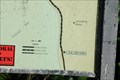 view gallery view galleryNW3.1 km |  Leinster Bay Trail - St. John USVI Leinster Bay Trail - St. John USVI
in 'You Are Here' Maps The Leinster Bay Trail in the US Virgin Island, St. John. posted by:  partlizard partlizard location: US Virgin Islands date approved: 01/31/2009 last visited: 07/04/2022 |
 view gallery view gallery W6.4 km W6.4 km
| ") Virgin Islands National Park - Virgin Islands Virgin Islands National Park - Virgin Islands
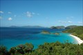
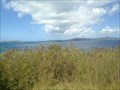
in National Parks (U.S.) Virgin Islands National Park covers over 7,000 acres. The park includes hiking trails, camping sites, beaches, and coral reefs. posted by: Free2bme29 location: US Virgin Islands date approved: 04/19/2013 last visited: 07/04/2022 |
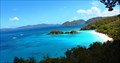
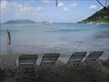
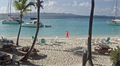
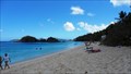 view gallery view galleryW6.4 km |  Trunk Bay - St. John, USVI Trunk Bay - St. John, USVI
in Beaches This is a beautiful white sand beach on the island of St. John. The beach is one of the main attractions within the Virgin Islands National Park. posted by: Free2bme29 location: US Virgin Islands date approved: 04/18/2013 last visited: 07/04/2022 |
 view gallery view galleryW6.8 km |  Trunk Bay Overlook Trunk Bay Overlook
in Scenic Roadside Look-Outs Trunk Bay is the most beautiful beach in the world! posted by: partlizard location: US Virgin Islands date approved: 01/07/2009 last visited: 07/04/2022 |
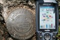 view gallery view galleryW7.4 km |  Survey Mark Peace Hill St John USVI Survey Mark Peace Hill St John USVI
in U.S. Benchmarks Survey marker found at the Peace Hill Sugar plantation ruins on St. John US Virgin Islands posted by: Moony Padfoot and Prongs location: US Virgin Islands date approved: 08/10/2007 last visited: 01/28/2009 |
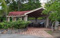 view gallery view galleryW9.3 km |  U.S. Virgins Islands National Park Visitors Center Pergola - St John USVI U.S. Virgins Islands National Park Visitors Center Pergola - St John USVI
in Pergolas U.S. Virgins Islands National Park Visitors Center Pergola posted by: kJfishman location: US Virgin Islands date approved: 11/17/2016 last visited: 07/04/2022 |
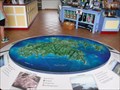 view gallery view galleryW9.3 km |  Virgin Islands National Park Map - St. John USVI Virgin Islands National Park Map - St. John USVI
in 3D Map Models of Our World and Beyond Virgin Islands National Park Map St. John USVI posted by: kJfishman location: US Virgin Islands date approved: 11/18/2016 last visited: 07/04/2022 |
 view gallery view galleryW9.3 km |  U.S. Virgins Islands National Park Stamp St. John USVI U.S. Virgins Islands National Park Stamp St. John USVI
in NPS Passport Cancellation Stations You can get 4 different stamps here. posted by: kJfishman location: US Virgin Islands date approved: 11/14/2016 last visited: 02/12/2022 |
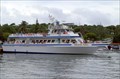 view gallery view galleryW9.3 km |  Cruz Bay Ferry Dock - St. John U.S.V.I Cruz Bay Ferry Dock - St. John U.S.V.I
in Ferries and Ferry Landings This small island main access is by ferry. posted by: kJfishman location: US Virgin Islands date approved: 01/09/2017 last visited: 07/09/2022 |
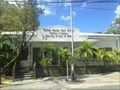 view gallery view galleryW9.5 km |  Cruz Bay, USVI, - 00830 Cruz Bay, USVI, - 00830
in U.S. Post Offices A post office on St. John, USVI posted by: chrissyml location: US Virgin Islands date approved: 04/05/2021 last visited: 07/09/2022 |
 view gallery view galleryW9.7 km |  Lind Point Trail, St. John, USVI Lind Point Trail, St. John, USVI
in Scenic Hikes Connects the National Park Visitor Center at Cruz Bay with Honeymoon Beach at Caneel Bay. Trail ascends .4 miles to scenic Lind Point overlook (elev. 160 ft.). At .7 miles, a side trail leads to Salomon Beach. (source: nps.gov) posted by: chrissyml location: US Virgin Islands date approved: 06/10/2015 last visited: never |
 view gallery view gallery NE10.1 km NE10.1 km
| Cane Garden Bay Beach, Tortola, British Virgin Islands in Beaches One of the WOW beaches of the British Virgin Islands! located in a natural cove creating great protection. White sand and cold drinks. Highly Recomended. posted by: PersonsMD location: British Virgin Islands date approved: 01/13/2010 last visited: 03/19/2019 |
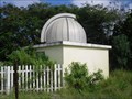 view gallery view galleryNE11.6 km |  British Virgin Islands Community College Observatory British Virgin Islands Community College Observatory
in Astronomical Observatories Located on the island of Tortola in the British Islands this facility is operated in partnership with the BVI Community College and the Cincinnati Astronomical Society. posted by: PersonsMD location: British Virgin Islands date approved: 01/12/2010 last visited: 12/22/2011 |
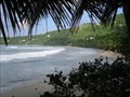 view gallery view galleryNE12.1 km | Brewers Bay Beach, Brewers Bay, Tortola, British Virgin Islands in Beaches Nearly isolated this beach is a wonderful place to get away from the real world. A couple of service providers but mostly as nature made intended. posted by: PersonsMD location: British Virgin Islands date approved: 01/13/2010 last visited: 01/04/2010 |
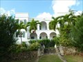
 view gallery view galleryNE12.1 km |  Old Government House - Road Town, Tortola, British Virgin Islands Old Government House - Road Town, Tortola, British Virgin Islands
in Philatelic Photographs Old Government House is located on the side of a hill on the west side of Waterfront Drive in Road Town, Tortola, BVI. posted by:  neoc1 neoc1 location: British Virgin Islands date approved: 04/08/2019 last visited: never |
 view gallery view galleryNE12.1 km |  Government House - Road Town, Tortola, British Virgin Islands Government House - Road Town, Tortola, British Virgin Islands
in Wikipedia Entries The Government House is located on the side of a hill on the west side of Waterfront Drive in Road Town, Tortola, BVI. posted by: neoc1 location: British Virgin Islands date approved: 02/29/2020 last visited: never |
 view gallery view galleryNE12.1 km |  Old Government House - Road Town, Tortola, British Virgin Islands Old Government House - Road Town, Tortola, British Virgin Islands
in Satellite Imagery Oddities The Old Government House is located on the side of a hill on the west side of Waterfront Drive in Road Town, Tortola, BVI. posted by: neoc1 location: British Virgin Islands date approved: 03/01/2020 last visited: never |
 view gallery view galleryNW12.1 km |  Soggy Dollar Bar Webcam - Jost Van Dyke, British Virgin Islands Soggy Dollar Bar Webcam - Jost Van Dyke, British Virgin Islands
in Web Cameras Jost Van Dyke (sometimes colloquially referred to as JVD or Jost) is the smallest of the four main islands of the British Virgin Islands, measuring roughly 8 square kilometres (3 square miles). posted by: Noe1 location: British Virgin Islands date approved: 02/06/2017 last visited: never |
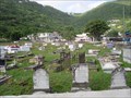 view gallery view galleryNE12.2 km |  Methodist Cemetery, Road Town, Tortola, British Virgin Islands (BVI) Methodist Cemetery, Road Town, Tortola, British Virgin Islands (BVI)
in Worldwide Cemeteries The City cemetery of Road Town located on Tortola island in the British Virgin Islands. posted by: PersonsMD location: British Virgin Islands date approved: 01/12/2010 last visited: 01/04/2010 |
 view gallery view galleryNE12.2 km |  Sir James Olva Georges - Road Town, Tortola, British Virgin Islands Sir James Olva Georges - Road Town, Tortola, British Virgin Islands
in Statues of Historic Figures A statue of Sir James Olva Georges, the only citizen of the British Virgin Islands to be knighted by Queen Elizabeth II, is located in Olva Georges Plaza in Road Town, Tortola, British Virgin Islands. posted by: neoc1 location: British Virgin Islands date approved: 03/31/2019 last visited: never |
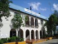 view gallery view galleryNE12.2 km |  Police Headquarters, Road Town, tortola, British Virgin Islands Police Headquarters, Road Town, tortola, British Virgin Islands
in Police Stations Located on main street in Road Town this building serves as the Headquarters for the police force of Road Town, Tortola, British Virgin Islands. posted by: PersonsMD location: British Virgin Islands date approved: 01/12/2010 last visited: 12/05/2013 |
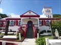 view gallery view galleryNE12.2 km |  St. George's Episcopal (Anglican) Church - Road Town, Tortola, British Virgin Islands St. George's Episcopal (Anglican) Church - Road Town, Tortola, British Virgin Islands
in Anglican and Episcopal Churches St. George's Episcopal (Anglican) Church is located at 170 Main Street in Road Town, Tortola, British Virgin Islands. posted by: neoc1 location: British Virgin Islands date approved: 03/06/2020 last visited: never |
 view gallery view galleryNE12.2 km |  St. George's Episcopal (Anglican) Church - Road Town, Tortola, British Virgin Islands St. George's Episcopal (Anglican) Church - Road Town, Tortola, British Virgin Islands
in This Old Church St. George's Episcopal (Anglican) Church is located at 170 Main Street in Road Town, Tortola, British Virgin Islands. posted by: neoc1 location: British Virgin Islands date approved: 03/07/2020 last visited: never |
|