 view gallery view gallery NE3.5 km NE3.5 km
|   St. Aidan's Anglican Church - Bathsheba, St. Joseph Parish, Barbados St. Aidan's Anglican Church - Bathsheba, St. Joseph Parish, Barbados
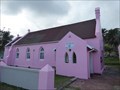
in This Old Church St. Aidan's Anglican Church is located in Bathsheba, St. Joseph Parish on Highway Z the central Atlantic Coast of Bardados. posted by:  neoc1 neoc1 location: Barbados date approved: 01/29/2023 last visited: never |
 view gallery view galleryNE3.5 km |  St. Aidan's Anglican Church - Bathsheba, St. Joseph Parish, Barbados St. Aidan's Anglican Church - Bathsheba, St. Joseph Parish, Barbados
in Victorian Style Architecture St. Aidan's Anglican Church is located in Bathsheba, St. Joseph Parish on Highway Z the central Atlantic Coast of Bardados. posted by: neoc1 location: Barbados date approved: 01/28/2023 last visited: never |
 view gallery view galleryNE3.5 km |  St. Aidan's Anglican Church - Bathsheba, St. Joseph Parish, Barbados St. Aidan's Anglican Church - Bathsheba, St. Joseph Parish, Barbados
in Anglican and Episcopal Churches St. Aidan's Anglican Church is located in Bathsheba, St. Joseph Parish on Highway Z the central Atlantic Coast of Bardados. posted by: neoc1 location: Barbados date approved: 03/18/2021 last visited: never |
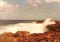
 view gallery view galleryNE3.5 km |  Bathsheba Beach - Bathsheba, St. Joseph Parish, Barbados Bathsheba Beach - Bathsheba, St. Joseph Parish, Barbados
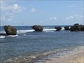
in Wavy Places The area around Bathsheba Beach is a world renown surfing area. It is located on the on the Atlantic Ocean of Barbados on the central east coast of Barbados adjacent to Highway 2. posted by: neoc1 location: Barbados date approved: 01/28/2023 last visited: never |
 view gallery view gallery E3.9 km E3.9 km
|  St. John Parish Church - Hackleton's Cliff, Barbados St. John Parish Church - Hackleton's Cliff, Barbados
in Wikipedia Entries St. John Parish (Anglican) Church is located in St. John Parish on the east side of the central coast of Barbados. posted by: neoc1 location: Barbados date approved: 03/27/2020 last visited: never |
 view gallery view galleryE3.9 km |  St. John Parish Church - Hackleton's Cliff, Barbados St. John Parish Church - Hackleton's Cliff, Barbados
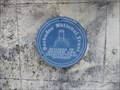
in Blue Plaques St. John Parish (Anglican) Church is located in St. John Parish on the east side of the central coast of Barbados. posted by: neoc1 location: Barbados date approved: 03/31/2020 last visited: never |
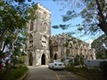 view gallery view galleryE3.9 km | St. John Parish Church - Hackleton's Cliff, Barbados in This Old Church St. John Parish (Anglican) Church is located in St. John Parish on the east side of the central coast of Barbados. posted by: neoc1 location: Barbados date approved: 03/30/2020 last visited: never |
 view gallery view galleryE3.9 km | St. John Parish Church - Hackleton's Cliff, Barbados in Anglican and Episcopal Churches St. John Parish (Anglican) Church is located in St. John Parish on the east side of the central coast of Barbados. posted by: neoc1 location: Barbados date approved: 03/29/2020 last visited: never |
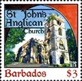 view gallery view galleryE3.9 km |  St. John's (Anglican) Parish Church - Hackleton's Cliff, Barbados St. John's (Anglican) Parish Church - Hackleton's Cliff, Barbados
in Philatelic Photographs St. John's (Anglican) Parish Church is located in St. John Parish on the east side of the central coast of Barbados. posted by: neoc1 location: Barbados date approved: 03/30/2020 last visited: never |
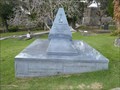 view gallery view galleryE3.9 km |  David John Howard Thompson - St. John's Parish, Barbados David John Howard Thompson - St. John's Parish, Barbados
in Grave of a Famous Person The tomb of lawyer and former Prime Minister of Barbados David John Howard Thompson is located in the graveyard of the St. John's Parish Church in Barbados. posted by: neoc1 location: Barbados date approved: 03/26/2020 last visited: never |
 view gallery view galleryE3.9 km |  St. John Parish Churchyard - St. John, Barbados St. John Parish Churchyard - St. John, Barbados
in Churchyard Cemeteries St. John Parish (Anglican) Church is located in St. John Parish on the east side of the central coast of Barbados. The churchyard cemetery is primarily located in the rear of the church. posted by: neoc1 location: Barbados date approved: 05/11/2020 last visited: 12/12/2008 |
 view gallery view gallery SW5.1 km SW5.1 km
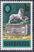
| Lion At Gun Hill - St. George, Barbados in Philatelic Photographs The Lion at Gun Hill is located on the cliff southwest of the Gun Hill Signal Station in St. George, Barbados. posted by: neoc1 location: Barbados date approved: 02/10/2013 last visited: 02/10/2018 |
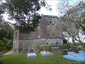
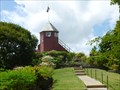
 view gallery view gallerySW5.1 km |  Gun Hill Signal Station - St. George, Barbados Gun Hill Signal Station - St. George, Barbados
in Official Local Tourism Attractions Gun Hill Signal Station is located on top of Gun Hill Cliff in the town of St. George in Barbados. posted by: neoc1 location: Barbados date approved: 08/07/2013 last visited: 02/10/2018 |
 view gallery view gallerySW5.1 km | Gun Hill Signal Station - St. George, Barbados in Blue Plaques Gun Hill Signal Station is located on top of Gun Hill Cliff in the town of St. George in Barbados. posted by: neoc1 location: Barbados date approved: 02/18/2013 last visited: never |
 view gallery view gallerySW5.1 km |  Gun Hill Signal Station - St. George, Barbados Gun Hill Signal Station - St. George, Barbados
in Look-Out Towers Gun Hill Signal Station is located on top of Gun Hill Cliff in the town of St. George in Barbados. posted by: neoc1 location: Barbados date approved: 08/07/2013 last visited: 02/10/2018 |
 view gallery view gallerySW5.1 km | Gun Hill Signal Station - St. George, Barbados in Wikipedia Entries Gun Hill Signal Station is located on top of Gun Hill Cliff in the town of St. George in Barbados. posted by: neoc1 location: Barbados date approved: 02/28/2020 last visited: never |
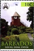 view gallery view gallerySW5.1 km | Gun Hill Signal Station - St. George, Barbados in Philatelic Photographs Gun Hill Signal Station is located on top of Gun Hill Cliff in the town of St. George in Barbados. posted by: neoc1 location: Barbados date approved: 02/17/2013 last visited: 02/10/2018 |
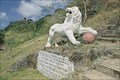 view gallery view gallerySW5.1 km |  Gun Hill Lion Gun Hill Lion
in Lion Statues This statue of a lion was carved out of a single piece of rock in 1868 by an officer at stationed at a nearby signal station. posted by:  Beagle-1 Beagle-1 location: Barbados date approved: 02/26/2008 last visited: 02/10/2018 |
 view gallery view gallery W5.6 km W5.6 km
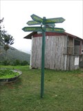
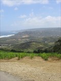
|  Mt Misery Direction Arrows Mt Misery Direction Arrows
in Direction and Distance Arrows Distance and direction arrows on a hill top, north central Barbados posted by: Beagle-1 location: Barbados date approved: 02/24/2008 last visited: never |
 view gallery view gallery NW10.5 km NW10.5 km
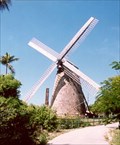
|  Morgan Lewis Sugar Mill Morgan Lewis Sugar Mill
in Windmills Morgan Lewis Mill is located on a scenic mount in the beautiful north east of the island of Barbados, commanding panoramic views down to the stunning east coast. posted by: Beagle-1 location: Barbados date approved: 02/19/2008 last visited: 02/10/2018 |
 view gallery view galleryE11.1 km | Ragged Point Cliffs- St. Philip, Barbados in Wavy Places The cliffs of Ragged Point are situated near the East Point Lighthouse in St. Philip, Barbados. posted by:  denben denben location: Barbados date approved: 12/23/2012 last visited: never |
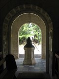 view gallery view galleryW11.4 km |  God Bless King William 1696 God Bless King William 1696
in Bells Bell on display at St James Parish Church, Holetown, Barbados posted by: Beagle-1 location: Barbados date approved: 02/21/2008 last visited: 10/18/2010 |
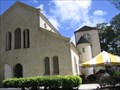 view gallery view galleryW11.4 km | St James Parish Church, Holetown, St. James, Barbados in This Old Church Located in Holetown, St. James Parish Church stands on one of the oldest parcels of consecrated land on the Island, often known in Barbados as "God's acre".
posted by: Beagle-1 location: Barbados date approved: 02/21/2008 last visited: 10/18/2010 |
 view gallery view galleryW11.4 km |  First Church in Barbados First Church in Barbados
in First of its Kind St James church is the first (oldest) church in Barbados posted by: Beagle-1 location: Barbados date approved: 02/21/2008 last visited: 10/18/2010 |
 view gallery view galleryNW11.4 km |  Cherry Tree Hill Cherry Tree Hill
in Scenic Roadside Look-Outs Offers a a spectacular view of the eastern and northern sections of Barbados at approx. 850 feet above sea-level. posted by: Beagle-1 location: Barbados date approved: 02/24/2008 last visited: 09/30/2016 |
|