 view gallery view gallery W20 km W20 km
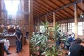
|   El Cafe de la Vaca - Cayambe, Ecuador El Cafe de la Vaca - Cayambe, Ecuador
in Independent Breakfast Spots Given 4 out of 5 stars by TripAdvisor reviewers, El Cafe de la Vaca offers breakfast served Ecuadorian style. Many of the ingredients come fresh from the farm. posted by:  Trail Blaisers Trail Blaisers location: Ecuador date approved: 07/03/2014 last visited: never |
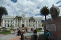 view gallery view gallery NW39.3 km NW39.3 km
|  Otavalo, Ecuador Otavalo, Ecuador
in City and Town Halls Otavalo's City Hall looks out stately over Plaza Bolivar, the civic centre of the largely indigenous city of Otavalo. posted by: Trail Blaisers location: Ecuador date approved: 06/27/2014 last visited: never |
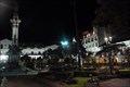
 view gallery view galleryNW39.3 km |  Zona Wi-Fi - Otavalo, Ecuador Zona Wi-Fi - Otavalo, Ecuador
in Wi-Fi Hotspots Travelers who are on the look out for free wi-fi should stop into Otavalo's beautiful main square and have a seat. Afterwards walk a couple of blocks for one of Ecuador's most spectacular artisan markets. posted by: Trail Blaisers location: Ecuador date approved: 06/27/2014 last visited: never |
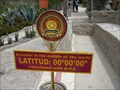 view gallery view galleryW51.5 km |  The equator- Quito, Equador The equator- Quito, Equador
in Great Lines of Earth An equator is the intersection of a sphere's surface with the plane perpendicular to the sphere's axis of rotation and containing the sphere's center of mass. posted by: superstein location: Ecuador date approved: 06/28/2010 last visited: 09/20/2022 |
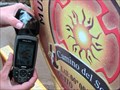 view gallery view galleryW51.5 km |  Pathway of the Sun Museum (Museo de sitio Inti-ñan) at the equator Pathway of the Sun Museum (Museo de sitio Inti-ñan) at the equator
in Geographical Centers The outdoor Pathway of the Sun Museum (Museo de sitio Inti-ñan) located at the equator near Quito, Ecuador posted by: honeybee77 location: Ecuador date approved: 12/22/2007 last visited: 12/27/2014 |
 view gallery view galleryW51.5 km |  Sumajman Quito, Ecuador Geocaching Tour Guide Sumajman Quito, Ecuador Geocaching Tour Guide
in Geocaching Tour Guides I am available when not traveling to guide you around to some of the Quito area geocaches. You should write me several weeks in advance to see if I'm in town. Tambien desponible para ensenarles a los nuevos que quieren aprender. posted by:  sumajman sumajman location: Ecuador date approved: 10/31/2008 last visited: never |
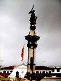
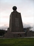 view gallery view galleryW51.5 km | Middle of the World (Mitad del Mundo) Monument near Quito, Ecuador in Geographical Centers Middle of the World Monument located at the equator near Quito, Ecuador. posted by: honeybee77 location: Ecuador date approved: 12/22/2007 last visited: 09/20/2022 |
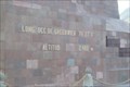 view gallery view galleryW51.7 km |  2,483 m - Quito, Ecuador 2,483 m - Quito, Ecuador
in Elevation Signs Find the coordinates on the monument marking the Equator. Due to some miscalculations 268 years ago, the surveyors were about 30 metres off. Based on my lack of breath, I can only assume the altitude here at 1.5 miles above sea level is correct! posted by: Trail Blaisers location: Ecuador date approved: 06/28/2014 last visited: 12/27/2014 |
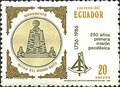 view gallery view galleryW51.7 km |  Monumento Mitad del Mundo - Quito, Ecuador Monumento Mitad del Mundo - Quito, Ecuador
in Philatelic Photographs This 20 sucre stamp from 1986 commemorates the 250th anniversary of the mapping of the Equator. posted by: Trail Blaisers location: Ecuador date approved: 06/29/2014 last visited: 09/20/2022 |
 view gallery view gallery SW62.8 km SW62.8 km
|  Monument to Heroes de la Independecia - Quito, Ecuador Monument to Heroes de la Independecia - Quito, Ecuador
in Political Revolutions A monument to the heroes at the start of Ecuador's war for independence from Spain in 1820. posted by: Metro2 location: Ecuador date approved: 06/22/2016 last visited: 09/20/2022 |
 view gallery view gallerySW62.8 km |  Plaza de la Independencia - Quito, Ecuador Plaza de la Independencia - Quito, Ecuador
in Municipal Parks and Plazas Also called La Plaza Grande, this became the main square of Quito in the 16th century. Afraid the Incas might poison their water supply, the Spanish set up their own protected well here, and this plaza subsequently became the social center of town. posted by: Trail Blaisers location: Ecuador date approved: 06/26/2014 last visited: 09/20/2022 |
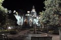
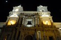
 view gallery view gallerySW62.9 km |  Quito's Historic Centre at Night - Quito, Ecuador Quito's Historic Centre at Night - Quito, Ecuador
in Scenic at Night At night Quito's historic centre takes on a special beauty. Photograph it from above or within to visit this waymark. posted by: Trail Blaisers location: Ecuador date approved: 06/27/2014 last visited: 12/27/2014 |
 view gallery view gallerySW62.9 km |  Historic Quito, UNESCO World Heritage Site - Quito, Ecuador Historic Quito, UNESCO World Heritage Site - Quito, Ecuador
in World Heritage Sites The City of Quito was one of the first UNESCO designated Heritage Sites. With hundreds of buildings dating 200-400 years old the city is an interesting example of a city struggling to preserve its heritage while adapting to modern civilization. posted by: Trail Blaisers location: Ecuador date approved: 06/26/2014 last visited: 09/20/2022 |
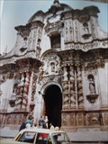 view gallery view gallerySW63.1 km |  Compañía de Jesús - Quito, Ecuador Compañía de Jesús - Quito, Ecuador
in Wikipedia Entries This Church, known as the Church of the Society of Jesus in English, was completed in 1765. posted by: Metro2 location: Ecuador date approved: 06/18/2016 last visited: 11/18/2021 |
 view gallery view gallerySW63.1 km |  Iglesia San Francisco - Quito, Ecuador Iglesia San Francisco - Quito, Ecuador
in This Old Church Quito is a deeply religious town. It holds some of the most spectacular temples in the Americas, San Francisco being one of them. Groundbreaking for Iglesia San Francisco was in 1534 and it was completed 70 years later in 1604. posted by: Trail Blaisers location: Ecuador date approved: 06/26/2014 last visited: 12/27/2014 |
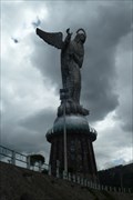 view gallery view gallerySW63.9 km |  Virgen de Quito on El Panecillo - Quito, Ecuador Virgen de Quito on El Panecillo - Quito, Ecuador
in Statues of Religious Figures Made of 7,000 pieces of aluminum, Virgen de Quito is a 45 metre tall statue on top of a large pedestal. The madonna looks out over the citizens of Quito from its dominate position on El Panecello hill. posted by: Trail Blaisers location: Ecuador date approved: 06/27/2014 last visited: 09/20/2022 |
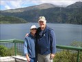
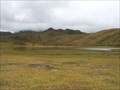 view gallery view gallerySW86.9 km |  Cotopaxi National Park, Laguna de Limpiopungo (Lake of Limpiopungo) Cotopaxi National Park, Laguna de Limpiopungo (Lake of Limpiopungo)
in Volcano Watching Laguna de Limpiopungo
A beautiful lake high in the mountains, at the foot of Cotopaxi Vulcano posted by: pachanor location: Ecuador date approved: 05/08/2008 last visited: 09/20/2022 |
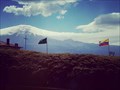
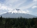 view gallery view gallerySW89.2 km | Cotopaxi - Ecuador in Elevation Signs At 4810 meters on the basekamp of the Cotopaxi. posted by: superstein location: Ecuador date approved: 07/24/2010 last visited: 09/22/2022 |
 view gallery view gallerySW90.8 km |  Cotopaxi - Pichincha, Ecuador Cotopaxi - Pichincha, Ecuador
in Satellite Imagery Oddities Cotopaxi is the second highest summit in Ecuador. posted by: kaschper69 location: Ecuador date approved: 09/10/2018 last visited: 09/10/2018 |
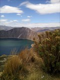 view gallery view gallerySW139 km | Quilotoa - Pujilí Canton, Cotopaxi Province, Ecuador in Satellite Imagery Oddities Lake Quilotoa at Pujilí Canton, Cotopaxi Province, Ecuador. posted by: kaschper69 location: Ecuador date approved: 09/10/2018 last visited: 09/20/2022 |
 view gallery view gallery S158.4 km S158.4 km
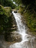
|  Manto del Angel Cascade Manto del Angel Cascade
in Waterfalls This is the first of 8 waterfalls trecking in Baños Ecuador posted by: pachanor location: Ecuador date approved: 05/07/2008 last visited: 12/27/2014 |
|