 view gallery view gallery S2.6 km S2.6 km
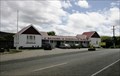
|   Waikawa Museum and Information Centre — Waikawa, New Zealand Waikawa Museum and Information Centre — Waikawa, New Zealand
in History Museums An extensive museum in a coastal village along the Southern Scenic Route. Well worth the stop and having a look around. posted by:  Dunbar Loop Dunbar Loop location: South Island, New Zealand date approved: 11/05/2009 last visited: never |
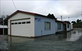
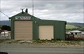 view gallery view galleryS2.6 km |  Waikawa Rural Fire Force Fire Station Waikawa Rural Fire Force Fire Station
in Firehouses A rural fire station in a coastal community. posted by: Dunbar Loop location: South Island, New Zealand date approved: 11/06/2009 last visited: never |
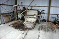 view gallery view galleryS2.6 km |  A binder and an assortment of agricultural equipment — Waikawa, New Zealand A binder and an assortment of agricultural equipment — Waikawa, New Zealand
in Old Agricultural Equipment A collection of old agricultural equipment that is housed at the Waikawa Museum. posted by: Dunbar Loop location: South Island, New Zealand date approved: 11/06/2009 last visited: never |
 view gallery view galleryS2.6 km |  Fortrose (Tokanui) Gaol — Waikawa, New Zealand Fortrose (Tokanui) Gaol — Waikawa, New Zealand
in Retired Prisons Built in 1918 the Fortrose gaol was shifted to Tokanui in the 1920s and then moved a second time in 1977 to the Waikawa Museum. Today it is a display at the museum. posted by: Dunbar Loop location: South Island, New Zealand date approved: 11/08/2009 last visited: never |
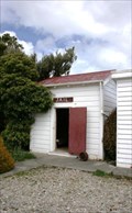 view gallery view galleryS2.6 km |  Fortrose (Tokanui) Gaol — Waikawa, New Zealand Fortrose (Tokanui) Gaol — Waikawa, New Zealand
in Relocated Structures This building was moved twice before coming to rest as part of a museum complex. The first move was from Fortrose to Tokanui, about 11 km. The second move was 25 km. posted by: Dunbar Loop location: South Island, New Zealand date approved: 02/11/2010 last visited: never |
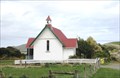 view gallery view galleryS2.7 km |  St Mary's Anglican Church — Waikawa, New Zealand St Mary's Anglican Church — Waikawa, New Zealand
in Anglican and Episcopal Churches St Mary's was built as an Anglican church in 1932 and performed this function until 1994. Today it is a part of the Waikawa Museum complex. On its original site, it is located the picturesque coastal community. posted by: Dunbar Loop location: South Island, New Zealand date approved: 11/05/2009 last visited: never |
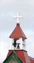 view gallery view galleryS2.7 km |  St Mary's Anglican Church — Waikawa, New Zealand St Mary's Anglican Church — Waikawa, New Zealand
in Bell Towers This former Anglican church in Waikawa features a wonderful bell tower. posted by: Dunbar Loop location: South Island, New Zealand date approved: 11/05/2009 last visited: never |
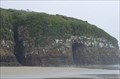
 view gallery view galleryS7.4 km |  Curio Bay — hoiho or yellow-eyed penguins — Curio Bay, New Zealand Curio Bay — hoiho or yellow-eyed penguins — Curio Bay, New Zealand
in Birdwatching Locations Considered to be among the rarest of penguins, the hoiho or yellow-eyed penguin has a colony of nesting birds in the native bush just above the high tide mark. Rarely seen except at dawn and dusk, these might prove to be elusive to a causal visit. posted by: Dunbar Loop location: South Island, New Zealand date approved: 11/05/2009 last visited: 11/26/2016 |
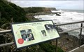
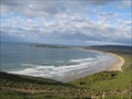
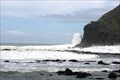 view gallery view galleryS7.4 km |  Curio Bay Curio Bay
in Wavy Places At high tide Curio Bay offers some spetacular wave viewing. During low tide the location is outstanding for a large petrified forest of tree stumps dating from the Jurassic period - about 170 million years ago. posted by: Dunbar Loop location: South Island, New Zealand date approved: 01/28/2010 last visited: 11/26/2016 |
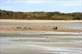
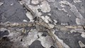 view gallery view galleryS7.4 km |  Petrified trunks and strains - Curio Bay - South Island - New Zealand Petrified trunks and strains - Curio Bay - South Island - New Zealand
in Paleontology and Fossils Curio Bay is a coastal embayment in the Southland District of New Zealand, best known as the site of a petrified forest some 180 million years old posted by:  franketmuriel franketmuriel location: South Island, New Zealand date approved: 02/06/2018 last visited: never |
 view gallery view gallery SW13.2 km SW13.2 km
|  S 46 40.40 E 169 00.03 - Slope Point S 46 40.40 E 169 00.03 - Slope Point
in Permanent Geographic Coordinates Southern most point of the south island of New Zealand. posted by: Hoblik location: South Island, New Zealand date approved: 04/14/2009 last visited: 11/26/2016 |
 view gallery view gallery E19 km E19 km
| ") Cathedral Caves - Tautuku Cathedral Caves - Tautuku
in Cave Entrances (Natural) This cave is located on the Southern Scenic Route of the South Island in the Catlins Region. posted by: StagsRoar location: South Island, New Zealand date approved: 10/26/2005 last visited: 11/24/2010 |
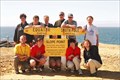
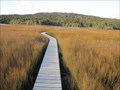 view gallery view galleryE21.9 km |  Tautuku Estuary Boardwalk - Tautuku, New Zealand Tautuku Estuary Boardwalk - Tautuku, New Zealand
in Coastal Boardwalks Boardwalk leading out to a salt water estuary. posted by:  BruceS BruceS location: South Island, New Zealand date approved: 02/08/2013 last visited: never |
 view gallery view gallery W22.5 km W22.5 km
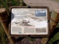
|  S.S. Tararua — Waipapa Point, New Zealand S.S. Tararua — Waipapa Point, New Zealand
in Signs of History New Zealand's worst civilian shipwreck with the loss 131 lives led to the installation of the Waipapa Point Lighthouse posted by: Dunbar Loop location: South Island, New Zealand date approved: 10/11/2009 last visited: 04/18/2015 |
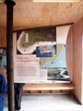 view gallery view galleryW22.5 km |  Welcome to Waipapa Point Welcome to Waipapa Point
in 'You Are Here' Maps This 'You Are Here' is housed inside a shelter from the wind and rain that is open to the public 24 hours a day. posted by: Dunbar Loop location: South Island, New Zealand date approved: 10/10/2009 last visited: 04/18/2015 |
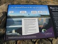
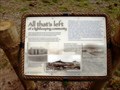 view gallery view galleryW22.7 km | All that's left of a lightkeeping community — Waipapa Point, New Zealand in Signs of History On the Lighthouse Reserve at Waipapa Point was a small village of lighthouse keepers and their families posted by: Dunbar Loop location: South Island, New Zealand date approved: 10/11/2009 last visited: 04/18/2015 |
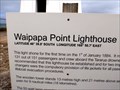
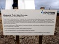 view gallery view galleryW22.9 km | Waipapa Point Lighthouse, New Zealand in Signs of History 1881 when the SS Tararua sank on a nearby reef leading the loss of 131 lives, New Zealand's worst civilian shipwreck, there was an urgent need to build a lighthouse at Waipapa Point. posted by: Dunbar Loop location: South Island, New Zealand date approved: 10/10/2009 last visited: 11/26/2016 |
 view gallery view galleryW22.9 km |  Waipapa Point Lighthouse, New Zealand Waipapa Point Lighthouse, New Zealand
in Coastal Lighthouses Built in 1884 as a result of the loss of 131 lives in 1881, Waipapa Point Lighthouse fully automated in 1976 and today uses solar powered LED technology to guide mariners along New Zealand's southern coastline. posted by: Dunbar Loop location: South Island, New Zealand date approved: 10/10/2009 last visited: 11/26/2016 |
 view gallery view galleryW22.9 km | 46° 39.8' S, 168° 50.7' E — Waipapa Point Lighthouse, New Zealand in Permanent Geographic Coordinates Waipapa Point Lighthouse has been guiding mariners since 1884. posted by: Dunbar Loop location: South Island, New Zealand date approved: 10/10/2009 last visited: 11/26/2016 |
 view gallery view galleryE25.1 km |  Florence Hill Lookout Orientation Table - Tautuku, New Zealand Florence Hill Lookout Orientation Table - Tautuku, New Zealand
in Orientation Tables Orientation table at a highway lookout along the Chaslands Highway in the Caitins on the South Island, New Zealand. posted by: BruceS location: South Island, New Zealand date approved: 01/27/2013 last visited: 04/18/2015 |
 view gallery view galleryE25.1 km |  Florence Hill Lookout - Tautuku, New Zealand Florence Hill Lookout - Tautuku, New Zealand
in Scenic Roadside Look-Outs Lookout along the Chaslands Highway in the Caitins on the South Island, New Zealand. posted by: BruceS location: South Island, New Zealand date approved: 01/26/2013 last visited: 04/18/2015 |
 view gallery view galleryW25.4 km |  Steamship "Ino" — Fortrose, New Zealand Steamship "Ino" — Fortrose, New Zealand
in Shipwrecks The Ino grounded in 1886 in the Fortrose harbour. posted by: Dunbar Loop location: South Island, New Zealand date approved: 10/12/2009 last visited: 04/18/2015 |
 view gallery view galleryE25.9 km |  Papatowai - South Island, New Zealand Papatowai - South Island, New Zealand
in Welcome Signs Welcome sign for the small community of Papatowai with a slogan "Where Forest Meets Sea" in the Caitlins area on the South Island, New Zealand. posted by: BruceS location: South Island, New Zealand date approved: 01/26/2013 last visited: 04/18/2015 |
 view gallery view galleryW26.1 km | New Zealand Fire Service Waimahaka Volunteer Brigade in Firehouses A small country hamlet fire hall posted by: Dunbar Loop location: South Island, New Zealand date approved: 09/16/2009 last visited: never |
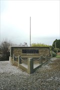 view gallery view galleryW26.2 km |  Waimahaka War Memorial — Waimahaka , New Zealand Waimahaka War Memorial — Waimahaka , New Zealand
in World War I Memorials and Monuments A small village war memorial that uses the most of the triangle shape of land it is located in. posted by: Dunbar Loop location: South Island, New Zealand date approved: 09/17/2009 last visited: never |
|