 view gallery view gallery SW10.6 km SW10.6 km
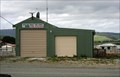
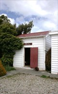
|   Waikawa Rural Fire Force Fire Station Waikawa Rural Fire Force Fire Station
in Firehouses A rural fire station in a coastal community. posted by:  Dunbar Loop Dunbar Loop location: South Island, New Zealand date approved: 11/06/2009 last visited: never |
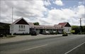 view gallery view gallerySW10.6 km |  Waikawa Museum and Information Centre — Waikawa, New Zealand Waikawa Museum and Information Centre — Waikawa, New Zealand
in History Museums An extensive museum in a coastal village along the Southern Scenic Route. Well worth the stop and having a look around. posted by: Dunbar Loop location: South Island, New Zealand date approved: 11/05/2009 last visited: never |
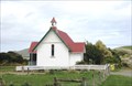 view gallery view gallerySW10.6 km |  St Mary's Anglican Church — Waikawa, New Zealand St Mary's Anglican Church — Waikawa, New Zealand
in Anglican and Episcopal Churches St Mary's was built as an Anglican church in 1932 and performed this function until 1994. Today it is a part of the Waikawa Museum complex. On its original site, it is located the picturesque coastal community. posted by: Dunbar Loop location: South Island, New Zealand date approved: 11/05/2009 last visited: never |
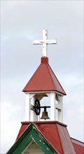 view gallery view gallerySW10.6 km |  St Mary's Anglican Church — Waikawa, New Zealand St Mary's Anglican Church — Waikawa, New Zealand
in Bell Towers This former Anglican church in Waikawa features a wonderful bell tower. posted by: Dunbar Loop location: South Island, New Zealand date approved: 11/05/2009 last visited: never |
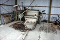 view gallery view gallerySW10.6 km |  A binder and an assortment of agricultural equipment — Waikawa, New Zealand A binder and an assortment of agricultural equipment — Waikawa, New Zealand
in Old Agricultural Equipment A collection of old agricultural equipment that is housed at the Waikawa Museum. posted by: Dunbar Loop location: South Island, New Zealand date approved: 11/06/2009 last visited: never |
 view gallery view gallerySW10.6 km |  Fortrose (Tokanui) Gaol — Waikawa, New Zealand Fortrose (Tokanui) Gaol — Waikawa, New Zealand
in Relocated Structures This building was moved twice before coming to rest as part of a museum complex. The first move was from Fortrose to Tokanui, about 11 km. The second move was 25 km. posted by: Dunbar Loop location: South Island, New Zealand date approved: 02/11/2010 last visited: never |
 view gallery view gallerySW10.6 km |  Fortrose (Tokanui) Gaol — Waikawa, New Zealand Fortrose (Tokanui) Gaol — Waikawa, New Zealand
in Retired Prisons Built in 1918 the Fortrose gaol was shifted to Tokanui in the 1920s and then moved a second time in 1977 to the Waikawa Museum. Today it is a display at the museum. posted by: Dunbar Loop location: South Island, New Zealand date approved: 11/08/2009 last visited: never |
 view gallery view gallery SE14 km SE14 km
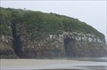
| ") Cathedral Caves - Tautuku Cathedral Caves - Tautuku
in Cave Entrances (Natural) This cave is located on the Southern Scenic Route of the South Island in the Catlins Region. posted by: StagsRoar location: South Island, New Zealand date approved: 10/26/2005 last visited: 11/24/2010 |
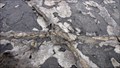 view gallery view gallerySW15.6 km |  Petrified trunks and strains - Curio Bay - South Island - New Zealand Petrified trunks and strains - Curio Bay - South Island - New Zealand
in Paleontology and Fossils Curio Bay is a coastal embayment in the Southland District of New Zealand, best known as the site of a petrified forest some 180 million years old posted by:  franketmuriel franketmuriel location: South Island, New Zealand date approved: 02/06/2018 last visited: never |
 view gallery view gallerySW15.6 km |  Curio Bay — hoiho or yellow-eyed penguins — Curio Bay, New Zealand Curio Bay — hoiho or yellow-eyed penguins — Curio Bay, New Zealand
in Birdwatching Locations Considered to be among the rarest of penguins, the hoiho or yellow-eyed penguin has a colony of nesting birds in the native bush just above the high tide mark. Rarely seen except at dawn and dusk, these might prove to be elusive to a causal visit. posted by: Dunbar Loop location: South Island, New Zealand date approved: 11/05/2009 last visited: 11/26/2016 |
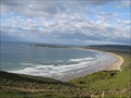
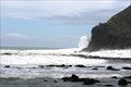 view gallery view gallerySW15.6 km |  Curio Bay Curio Bay
in Wavy Places At high tide Curio Bay offers some spetacular wave viewing. During low tide the location is outstanding for a large petrified forest of tree stumps dating from the Jurassic period - about 170 million years ago. posted by: Dunbar Loop location: South Island, New Zealand date approved: 01/28/2010 last visited: 11/26/2016 |
 view gallery view gallery E15.8 km E15.8 km
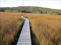
|  Tautuku Estuary Boardwalk - Tautuku, New Zealand Tautuku Estuary Boardwalk - Tautuku, New Zealand
in Coastal Boardwalks Boardwalk leading out to a salt water estuary. posted by:  BruceS BruceS location: South Island, New Zealand date approved: 02/08/2013 last visited: never |
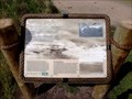
 view gallery view galleryE18.5 km |  Florence Hill Lookout Orientation Table - Tautuku, New Zealand Florence Hill Lookout Orientation Table - Tautuku, New Zealand
in Orientation Tables Orientation table at a highway lookout along the Chaslands Highway in the Caitins on the South Island, New Zealand. posted by: BruceS location: South Island, New Zealand date approved: 01/27/2013 last visited: 04/18/2015 |
 view gallery view galleryE18.5 km |  Florence Hill Lookout - Tautuku, New Zealand Florence Hill Lookout - Tautuku, New Zealand
in Scenic Roadside Look-Outs Lookout along the Chaslands Highway in the Caitins on the South Island, New Zealand. posted by: BruceS location: South Island, New Zealand date approved: 01/26/2013 last visited: 04/18/2015 |
 view gallery view galleryE19 km |  Papatowai - South Island, New Zealand Papatowai - South Island, New Zealand
in Welcome Signs Welcome sign for the small community of Papatowai with a slogan "Where Forest Meets Sea" in the Caitlins area on the South Island, New Zealand. posted by: BruceS location: South Island, New Zealand date approved: 01/26/2013 last visited: 04/18/2015 |
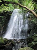 view gallery view galleryE21.1 km |  Matai Falls - Owaka, New Zealand Matai Falls - Owaka, New Zealand
in Waterfalls Waterfalls located in the Caitlins, 18 km south of Owaka. posted by: BruceS location: South Island, New Zealand date approved: 01/27/2013 last visited: never |
 view gallery view galleryE21.2 km | Horseshoe Falls - Owaka, New Zealand in Waterfalls Waterfalls located in the Caitlins, 18 km south of Owaka. posted by: BruceS location: South Island, New Zealand date approved: 01/27/2013 last visited: never |
 view gallery view gallerySW21.9 km |  S 46 40.40 E 169 00.03 - Slope Point S 46 40.40 E 169 00.03 - Slope Point
in Permanent Geographic Coordinates Southern most point of the south island of New Zealand. posted by: Hoblik location: South Island, New Zealand date approved: 04/14/2009 last visited: 11/26/2016 |
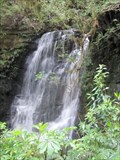
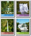 view gallery view galleryE26.2 km |  Purakaunui Falls - Owaka, New Zealand Purakaunui Falls - Owaka, New Zealand
in Philatelic Photographs Picturesque waterfalls located in the Catlins area about 17 km southwest of the small community of Owaka, New Zealand. posted by: BruceS location: South Island, New Zealand date approved: 01/27/2013 last visited: never |
 view gallery view galleryE26.2 km | Purakaunui Falls - Owaka, New Zealand in Waterfalls Picturesque waterfalls located in the Catlins area about 17 km southwest of the small community of Owaka, New Zealand. posted by: BruceS location: South Island, New Zealand date approved: 01/27/2013 last visited: never |
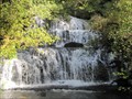 view gallery view galleryE26.2 km |  Purakaunui Falls - Owaka, New Zealand Purakaunui Falls - Owaka, New Zealand
in Wikipedia Entries Picturesque waterfalls located in the Catlins area about 17 km southwest of the small community of Owaka, New Zealand. posted by: BruceS location: South Island, New Zealand date approved: 01/27/2013 last visited: never |
 view gallery view galleryE29.6 km |  Ratanui Cemetery - Owaka, New Zealand Ratanui Cemetery - Owaka, New Zealand
in Abandoned Cemeteries Small abandoned cemetery in rural area southwest of Owaka, New Zealand. posted by: BruceS location: South Island, New Zealand date approved: 01/28/2013 last visited: never |
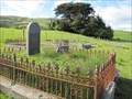 view gallery view galleryE29.6 km |  Ratanui Cemetery - Owaka, New Zealand Ratanui Cemetery - Owaka, New Zealand
in Worldwide Cemeteries Small abandoned cemetery in rural area southwest of Owaka, New Zealand. posted by: BruceS location: South Island, New Zealand date approved: 01/28/2013 last visited: never |
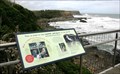
 view gallery view gallerySW30.7 km |  S.S. Tararua — Waipapa Point, New Zealand S.S. Tararua — Waipapa Point, New Zealand
in Signs of History New Zealand's worst civilian shipwreck with the loss 131 lives led to the installation of the Waipapa Point Lighthouse posted by: Dunbar Loop location: South Island, New Zealand date approved: 10/11/2009 last visited: 04/18/2015 |
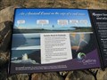
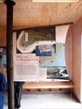 view gallery view gallerySW30.7 km |  Welcome to Waipapa Point Welcome to Waipapa Point
in 'You Are Here' Maps This 'You Are Here' is housed inside a shelter from the wind and rain that is open to the public 24 hours a day. posted by: Dunbar Loop location: South Island, New Zealand date approved: 10/10/2009 last visited: 04/18/2015 |
|