 view gallery view gallery E10.1 km E10.1 km
|   Balclutha Otago. New Zealand. Balclutha Otago. New Zealand.
in Welcome Signs Welcome to Balclutha - "Big River Town". posted by:  Punga and Paua Punga and Paua location: South Island, New Zealand date approved: 12/20/2009 last visited: 06/25/2012 |
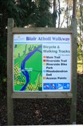 view gallery view galleryE11.4 km |  Blair Atholl Walkway — Naith Park access point Blair Atholl Walkway — Naith Park access point
in Hiking and walking trailheads The Blair Atholl Walkway runs along the stopbanks of the Clutha River at Balclutha. posted by:  Dunbar Loop Dunbar Loop location: South Island, New Zealand date approved: 08/23/2009 last visited: never |
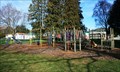
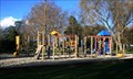 view gallery view galleryE11.4 km |  Naith Park Playground — Balclutha, New Zealand Naith Park Playground — Balclutha, New Zealand
in Public Playgrounds A nice playground in a quiet park. posted by: Dunbar Loop location: South Island, New Zealand date approved: 08/24/2009 last visited: 07/15/2012 |
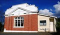
 view gallery view galleryE12.1 km |  Carnegie Library — Balclutha, New Zealand Carnegie Library — Balclutha, New Zealand
in Carnegie Library Buildings Built in 1913 the Carnegie Library, today the Balclutha Branch of the Clutha District Library System, is one of two original Carnegie Libraries that operate as borrowing libraries today. posted by: Dunbar Loop location: South Island, New Zealand date approved: 11/06/2009 last visited: 08/08/2013 |
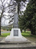
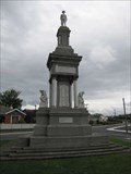 view gallery view galleryE12.1 km |  Balclutha Combined War Memorial - Balclutha, New Zealand Balclutha Combined War Memorial - Balclutha, New Zealand
in World War I Memorials and Monuments War memorial initially placed to honor fallen of the Great War with the fallen of World War II added later located in Balclutha, New Zealand. posted by:  BruceS BruceS location: South Island, New Zealand date approved: 02/01/2013 last visited: 12/13/2014 |
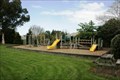 view gallery view galleryE15.1 km | Stirling Playground — Balclutha, New Zealand in Public Playgrounds This quiet neighbourhood playground is worth travelling the 2.4 km from SH 1 to visit. posted by: Dunbar Loop location: South Island, New Zealand date approved: 11/06/2009 last visited: 08/06/2012 |
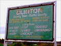
 view gallery view gallery W15.4 km W15.4 km
| Clinton, New Zealand in Welcome Signs Welcome sign for Clinton, New Zealand - "Our Three Horse Town" posted by: BruceS location: South Island, New Zealand date approved: 02/13/2013 last visited: 12/13/2014 |
 view gallery view galleryW16.3 km |  Clinton No. 183 — Clinton, New Zealand Clinton No. 183 — Clinton, New Zealand
in Masonic Temples A small lodge in Clinton. posted by: Dunbar Loop location: South Island, New Zealand date approved: 08/23/2009 last visited: 12/13/2014 |
 view gallery view galleryW16.6 km | "The Triangle" Playground — Clinton in Public Playgrounds A great playground right beside State Highway 1 that provides a break for kids and adults when driving from Invercargill to Dunedin posted by: Dunbar Loop location: South Island, New Zealand date approved: 08/24/2009 last visited: 12/13/2014 |
 view gallery view galleryW16.6 km | Clinton Combined War Memorial - Clinton, New Zealand in World War I Memorials and Monuments Memorial erected to honor the fallen of the Great War, another plaque was added to honor the the fallen of World War II. posted by: BruceS location: South Island, New Zealand date approved: 02/02/2013 last visited: 12/13/2014 |
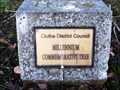 view gallery view galleryW16.6 km |  Clutha District Council Millennium Commemorative Tree — Clinton, New Zealand Clutha District Council Millennium Commemorative Tree — Clinton, New Zealand
in Millennium Trees A millennium tree planted in Clinton township. posted by: Dunbar Loop location: South Island, New Zealand date approved: 08/23/2009 last visited: 12/13/2014 |
 view gallery view galleryW16.7 km |  Clinton - 400 ft - South Otago. New Zealand. Clinton - 400 ft - South Otago. New Zealand.
in Elevation Signs Clinton, in South Otago, proudly displays the fact that it is 400 feet above sea level. posted by: Punga and Paua location: South Island, New Zealand date approved: 12/07/2009 last visited: 10/21/2015 |
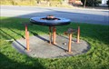 view gallery view galleryW16.7 km |  Wagon Wheel Picnic Tables — Clinton, New Zealand Wagon Wheel Picnic Tables — Clinton, New Zealand
in Wagon Wheels Two wagon wheels used as picnic tables in Clinton — the three horse town. posted by: Dunbar Loop location: South Island, New Zealand date approved: 08/23/2009 last visited: 12/13/2014 |
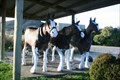 view gallery view galleryW16.7 km |  Three Horse Town — Clinton, New Zealand Three Horse Town — Clinton, New Zealand
in Fiberglass Horses Clinton refers to itself as the 'Three Horse Town' and they have installed three horses for all to see. posted by: Dunbar Loop location: South Island, New Zealand date approved: 03/30/2010 last visited: 10/21/2015 |
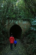 view gallery view gallery SE20.4 km SE20.4 km
|  Tunnel Hill — Owaka, New Zealand Tunnel Hill — Owaka, New Zealand
in Abandoned Train Tunnels Often claimed to be the southernmost railway tunnel in the world. posted by: Dunbar Loop location: South Island, New Zealand date approved: 08/23/2009 last visited: never |
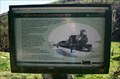 view gallery view gallerySE20.6 km |  Tunnel Hill — Owaka, New Zealand Tunnel Hill — Owaka, New Zealand
in Signs of History A series of signs explaining the significance and history of the tunnel on the Catlins River Branch of the NZ Railway network. posted by: Dunbar Loop location: South Island, New Zealand date approved: 08/24/2009 last visited: 06/24/2012 |
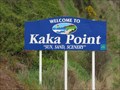 view gallery view gallerySE21.9 km | Kaka Point - New Zealand in Welcome Signs Welcome sign for the small community of Kaka Point, South Island, New Zealand. posted by: BruceS location: South Island, New Zealand date approved: 01/30/2013 last visited: 08/08/2013 |
 view gallery view gallery S23 km S23 km
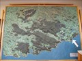
|  Catlins Locality Map - Owaka Museum - Owaka, New Zealand Catlins Locality Map - Owaka Museum - Owaka, New Zealand
in 3D Map Models of Our World and Beyond 3d map of the Catlins area of southeast New Zealand at the Owaka Museum. posted by: BruceS location: South Island, New Zealand date approved: 01/29/2013 last visited: never |
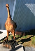 view gallery view galleryS23 km |  Moa — Owaka, New Zealand Moa — Owaka, New Zealand
in Outside Wooden Display Carvings This moa is outside of the Owaka Museum. posted by: Dunbar Loop location: South Island, New Zealand date approved: 08/24/2009 last visited: 04/18/2015 |
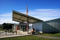 view gallery view galleryS23 km |  Owaka Branch — Clutha District Libraries Owaka Branch — Clutha District Libraries
in Libraries A small rural library branch that also is in the same building as the local museum and tourist centre. posted by: Dunbar Loop location: South Island, New Zealand date approved: 08/23/2009 last visited: 04/18/2015 |
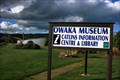 view gallery view galleryS23 km |  Owaka Museum | Wahi Kahuika - The Meeting Place Owaka Museum | Wahi Kahuika - The Meeting Place
in History Museums Covering 200 years of history in the Catlins, this museum has a wide range of topics starting from the days Maori-European contact. posted by: Dunbar Loop location: South Island, New Zealand date approved: 08/23/2009 last visited: 04/18/2015 |
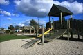 view gallery view galleryS23 km | Owaka Adventure Play Ground — Owaka in Public Playgrounds A wooden style playground with a fenced off toddlers area. posted by: Dunbar Loop location: South Island, New Zealand date approved: 08/24/2009 last visited: 04/18/2015 |
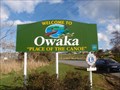 view gallery view galleryS23.2 km | Owaka — Place of the Canoe in Welcome Signs Owaka — Place of the Canoe posted by: Dunbar Loop location: South Island, New Zealand date approved: 08/23/2009 last visited: 12/10/2014 |
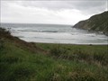 view gallery view gallerySE27.5 km |  Roaring Bay - New Zealand Roaring Bay - New Zealand
in Wavy Places Bay located along the southeast coast of the South Island, New Zealand with large waves. posted by: BruceS location: South Island, New Zealand date approved: 01/29/2013 last visited: 11/27/2016 |
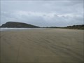 view gallery view gallerySE27.5 km |  Cannibal Bay Beach - Owaka, New Zealand Cannibal Bay Beach - Owaka, New Zealand
in Beaches Beach located east of Owaka, New Zealand. posted by: BruceS location: South Island, New Zealand date approved: 01/30/2013 last visited: never |
|