 view gallery view gallery NE16.6 km NE16.6 km
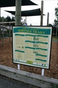
|   Whitehaven St Sites — Lawrence, New Zealand Whitehaven St Sites — Lawrence, New Zealand
in Signs of History Covering the length of Whitehaven Street, this sign discusses eight different locations along this street posted by:  Dunbar Loop Dunbar Loop location: South Island, New Zealand date approved: 11/29/2009 last visited: 11/16/2014 |
 view gallery view gallery W19 km W19 km
|  In Memory of Dr Snow — Tapanui, New Zealand In Memory of Dr Snow — Tapanui, New Zealand
in Citizen Memorials Dr Snow had an enquiring mind in medicine, geology, and Maori history. He is most famous for documenting Tapanui Flu, also known as Myalgic Encephalomyelitis or Chronic Fatigue Syndrome. posted by: Dunbar Loop location: South Island, New Zealand date approved: 03/09/2010 last visited: never |
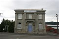 view gallery view galleryW19 km |  Bank of New Zealand — Tapanui, New Zealand Bank of New Zealand — Tapanui, New Zealand
in Converted Bank Buildings This Bank of New Zealand building is now a residence. posted by: Dunbar Loop location: South Island, New Zealand date approved: 03/07/2010 last visited: never |
 view gallery view galleryW19.2 km |  1950 — Margaret Ferguson Plunket and Rest Rooms — Tapanui, New Zealand 1950 — Margaret Ferguson Plunket and Rest Rooms — Tapanui, New Zealand
in Dated Buildings and Cornerstones Every New Zealand community has a Plunket Room. These are to benefit children by provided free nursing and guidance for parents. Few Kiwis have not been a part of the Plunket system. posted by: Dunbar Loop location: South Island, New Zealand date approved: 12/03/2009 last visited: never |
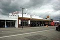 view gallery view galleryW19.2 km |  Wylie's Garage — Tapanui, New Zealand Wylie's Garage — Tapanui, New Zealand
in Vintage Gas Stations Located on State Highway 90, this vintage garage dates back to the 1920s and continues to service Tapanui with petrol. posted by: Dunbar Loop location: South Island, New Zealand date approved: 11/21/2009 last visited: never |
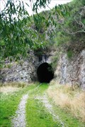 view gallery view gallery SW22.5 km SW22.5 km
|  No. 1 Tunnel — Tapanui Branch Line, New Zealand No. 1 Tunnel — Tapanui Branch Line, New Zealand
in Abandoned Train Tunnels Built for the 1880 opening of the Tapanui Branch Line, this line remained in operation until October 1978. posted by: Dunbar Loop location: South Island, New Zealand date approved: 03/07/2010 last visited: never |
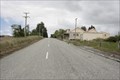 view gallery view gallery NW23.2 km NW23.2 km
|  Edievale, New Zealand Edievale, New Zealand
in Ghost Towns Edievale was the terminus for the Tapanui Branch of New Zealand Railways from 1905 until 1978. posted by: Dunbar Loop location: South Island, New Zealand date approved: 11/22/2009 last visited: never |
 view gallery view gallerySW24.5 km |  The Presidential Highway. South Island. New Zealand. The Presidential Highway. South Island. New Zealand.
in National Scenic Byways In New Zealand a famous section of State Highway 1 between the southern towns of Clinton and Gore is known as the scenic "Presidential Highway", after Bill Clinton and Al Gore. posted by:  Punga and Paua Punga and Paua location: South Island, New Zealand date approved: 12/07/2009 last visited: 02/08/2015 |
 view gallery view gallery S25.4 km S25.4 km
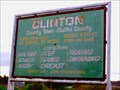
|  Clinton, New Zealand Clinton, New Zealand
in Welcome Signs Welcome sign for Clinton, New Zealand - "Our Three Horse Town" posted by:  BruceS BruceS location: South Island, New Zealand date approved: 02/13/2013 last visited: 12/13/2014 |
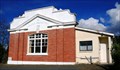 view gallery view galleryS25.9 km |  Clinton No. 183 — Clinton, New Zealand Clinton No. 183 — Clinton, New Zealand
in Masonic Temples A small lodge in Clinton. posted by: Dunbar Loop location: South Island, New Zealand date approved: 08/23/2009 last visited: 12/13/2014 |
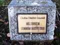 view gallery view galleryS25.9 km |  Clutha District Council Millennium Commemorative Tree — Clinton, New Zealand Clutha District Council Millennium Commemorative Tree — Clinton, New Zealand
in Millennium Trees A millennium tree planted in Clinton township. posted by: Dunbar Loop location: South Island, New Zealand date approved: 08/23/2009 last visited: 12/13/2014 |
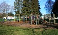 view gallery view galleryS25.9 km |  "The Triangle" Playground — Clinton "The Triangle" Playground — Clinton
in Public Playgrounds A great playground right beside State Highway 1 that provides a break for kids and adults when driving from Invercargill to Dunedin posted by: Dunbar Loop location: South Island, New Zealand date approved: 08/24/2009 last visited: 12/13/2014 |
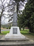 view gallery view galleryS25.9 km |  Clinton Combined War Memorial - Clinton, New Zealand Clinton Combined War Memorial - Clinton, New Zealand
in World War I Memorials and Monuments Memorial erected to honor the fallen of the Great War, another plaque was added to honor the the fallen of World War II. posted by: BruceS location: South Island, New Zealand date approved: 02/02/2013 last visited: 12/13/2014 |
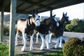 view gallery view galleryS26.2 km |  Three Horse Town — Clinton, New Zealand Three Horse Town — Clinton, New Zealand
in Fiberglass Horses Clinton refers to itself as the 'Three Horse Town' and they have installed three horses for all to see. posted by: Dunbar Loop location: South Island, New Zealand date approved: 03/30/2010 last visited: 10/21/2015 |
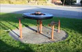 view gallery view galleryS26.2 km |  Wagon Wheel Picnic Tables — Clinton, New Zealand Wagon Wheel Picnic Tables — Clinton, New Zealand
in Wagon Wheels Two wagon wheels used as picnic tables in Clinton — the three horse town. posted by: Dunbar Loop location: South Island, New Zealand date approved: 08/23/2009 last visited: 12/13/2014 |
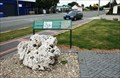
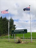
 view gallery view galleryS26.2 km |  Clinton - 400 ft - South Otago. New Zealand. Clinton - 400 ft - South Otago. New Zealand.
in Elevation Signs Clinton, in South Otago, proudly displays the fact that it is 400 feet above sea level. posted by: Punga and Paua location: South Island, New Zealand date approved: 12/07/2009 last visited: 10/21/2015 |
 view gallery view gallery N28 km N28 km
| Stewart’s Creek Bridge — Island Block, New Zealand in Citizen Memorials Erected in 1922 this bridge was dedicated to the memory of Robert & Isabella Stewart. posted by: Dunbar Loop location: South Island, New Zealand date approved: 03/28/2010 last visited: 04/29/2013 |
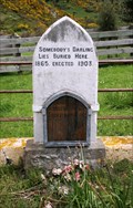 view gallery view galleryN28.8 km |  Somebody's Darling Lies Here Buried — Rigney, New Zealand Somebody's Darling Lies Here Buried — Rigney, New Zealand
in Graves of the Unknown In February 1865 a body was found in the Clutha River, a short distance from here, and was buried under a headstone reading "Somebody's Darling Lies Here Buried". A later inquest linked the corpse to one Charles Alms but the body was not identified. posted by: Dunbar Loop location: South Island, New Zealand date approved: 12/02/2009 last visited: 06/24/2012 |
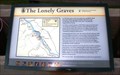 view gallery view galleryN28.8 km | The Lonely Graves — Rigney, New Zealand in Signs of History When an unidentified body was pulled from the Clutha River little did anyone know it would begin a legend that would still exist today. The burial of 'Somebody's Darling Lies Here' and William Rigney has left a region an interesting story. posted by: Dunbar Loop location: South Island, New Zealand date approved: 12/01/2009 last visited: 04/29/2013 |
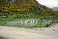 view gallery view galleryN28.8 km |  Lonely Graves Historical Reserve — Rigney, New Zealand Lonely Graves Historical Reserve — Rigney, New Zealand
in Worldwide Cemeteries These two graves are the source of a local legend. Somebody's Darling Lies Buried Here and William Rigney, The Man Who Buried "Somebody's Darling", have created a story that has been passed down through generations since 1865. posted by: Dunbar Loop location: South Island, New Zealand date approved: 12/02/2009 last visited: 04/29/2013 |
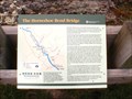 view gallery view galleryN29.1 km | The Horseshoe Bend Bridge — Rigney, New Zealand in Signs of History The plight of a community trying to access the main road across the Clutha River posted by: Dunbar Loop location: South Island, New Zealand date approved: 11/22/2009 last visited: 04/29/2013 |
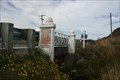
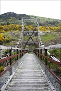 view gallery view galleryN29.1 km |  Horseshoe Bend Suspension Bridge — Rigney, New Zealand Horseshoe Bend Suspension Bridge — Rigney, New Zealand
in Pedestrian Suspension Bridges Built in 1913 and fully restored in 2005, the pedestrian suspension bridge connected the community of Rigney to Raes Junction on the main road posted by: Dunbar Loop location: South Island, New Zealand date approved: 05/08/2010 last visited: 04/29/2013 |
 view gallery view gallery SE33.5 km SE33.5 km
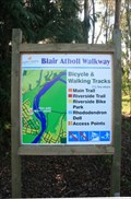
|  Blair Atholl Walkway — Naith Park access point Blair Atholl Walkway — Naith Park access point
in Hiking and walking trailheads The Blair Atholl Walkway runs along the stopbanks of the Clutha River at Balclutha. posted by: Dunbar Loop location: South Island, New Zealand date approved: 08/23/2009 last visited: never |
 view gallery view gallerySE33.5 km | Balclutha Otago. New Zealand. in Welcome Signs Welcome to Balclutha - "Big River Town". posted by: Punga and Paua location: South Island, New Zealand date approved: 12/20/2009 last visited: 06/25/2012 |
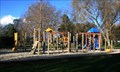 view gallery view gallerySE33.5 km | Naith Park Playground — Balclutha, New Zealand in Public Playgrounds A nice playground in a quiet park. posted by: Dunbar Loop location: South Island, New Zealand date approved: 08/24/2009 last visited: 07/15/2012 |
|