 view gallery view gallery S12.7 km S12.7 km
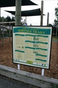
|   Whitehaven St Sites — Lawrence, New Zealand Whitehaven St Sites — Lawrence, New Zealand
in Signs of History Covering the length of Whitehaven Street, this sign discusses eight different locations along this street posted by:  Dunbar Loop Dunbar Loop location: South Island, New Zealand date approved: 11/29/2009 last visited: 11/16/2014 |
 view gallery view gallery NW19 km NW19 km
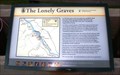
| The Lonely Graves — Rigney, New Zealand in Signs of History When an unidentified body was pulled from the Clutha River little did anyone know it would begin a legend that would still exist today. The burial of 'Somebody's Darling Lies Here' and William Rigney has left a region an interesting story. posted by: Dunbar Loop location: South Island, New Zealand date approved: 12/01/2009 last visited: 04/29/2013 |
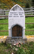 view gallery view galleryNW19 km |  Somebody's Darling Lies Here Buried — Rigney, New Zealand Somebody's Darling Lies Here Buried — Rigney, New Zealand
in Graves of the Unknown In February 1865 a body was found in the Clutha River, a short distance from here, and was buried under a headstone reading "Somebody's Darling Lies Here Buried". A later inquest linked the corpse to one Charles Alms but the body was not identified. posted by: Dunbar Loop location: South Island, New Zealand date approved: 12/02/2009 last visited: 06/24/2012 |
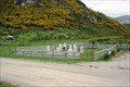 view gallery view galleryNW19 km |  Lonely Graves Historical Reserve — Rigney, New Zealand Lonely Graves Historical Reserve — Rigney, New Zealand
in Worldwide Cemeteries These two graves are the source of a local legend. Somebody's Darling Lies Buried Here and William Rigney, The Man Who Buried "Somebody's Darling", have created a story that has been passed down through generations since 1865. posted by: Dunbar Loop location: South Island, New Zealand date approved: 12/02/2009 last visited: 04/29/2013 |
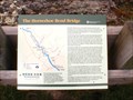 view gallery view galleryNW19.6 km | The Horseshoe Bend Bridge — Rigney, New Zealand in Signs of History The plight of a community trying to access the main road across the Clutha River posted by: Dunbar Loop location: South Island, New Zealand date approved: 11/22/2009 last visited: 04/29/2013 |
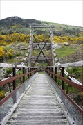 view gallery view galleryNW19.8 km |  Horseshoe Bend Suspension Bridge — Rigney, New Zealand Horseshoe Bend Suspension Bridge — Rigney, New Zealand
in Pedestrian Suspension Bridges Built in 1913 and fully restored in 2005, the pedestrian suspension bridge connected the community of Rigney to Raes Junction on the main road posted by: Dunbar Loop location: South Island, New Zealand date approved: 05/08/2010 last visited: 04/29/2013 |
 view gallery view gallery W20.1 km W20.1 km
|  Stewart’s Creek Bridge — Island Block, New Zealand Stewart’s Creek Bridge — Island Block, New Zealand
in Citizen Memorials Erected in 1922 this bridge was dedicated to the memory of Robert & Isabella Stewart. posted by: Dunbar Loop location: South Island, New Zealand date approved: 03/28/2010 last visited: 04/29/2013 |
 view gallery view galleryW26.2 km |  Edievale, New Zealand Edievale, New Zealand
in Ghost Towns Edievale was the terminus for the Tapanui Branch of New Zealand Railways from 1905 until 1978. posted by: Dunbar Loop location: South Island, New Zealand date approved: 11/22/2009 last visited: never |
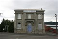 view gallery view gallery SW37.5 km SW37.5 km
|  Bank of New Zealand — Tapanui, New Zealand Bank of New Zealand — Tapanui, New Zealand
in Converted Bank Buildings This Bank of New Zealand building is now a residence. posted by: Dunbar Loop location: South Island, New Zealand date approved: 03/07/2010 last visited: never |
 view gallery view gallerySW37.5 km | In Memory of Dr Snow — Tapanui, New Zealand in Citizen Memorials Dr Snow had an enquiring mind in medicine, geology, and Maori history. He is most famous for documenting Tapanui Flu, also known as Myalgic Encephalomyelitis or Chronic Fatigue Syndrome. posted by: Dunbar Loop location: South Island, New Zealand date approved: 03/09/2010 last visited: never |
 view gallery view gallerySW37.7 km |  1950 — Margaret Ferguson Plunket and Rest Rooms — Tapanui, New Zealand 1950 — Margaret Ferguson Plunket and Rest Rooms — Tapanui, New Zealand
in Dated Buildings and Cornerstones Every New Zealand community has a Plunket Room. These are to benefit children by provided free nursing and guidance for parents. Few Kiwis have not been a part of the Plunket system. posted by: Dunbar Loop location: South Island, New Zealand date approved: 12/03/2009 last visited: never |
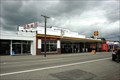 view gallery view gallerySW37.8 km |  Wylie's Garage — Tapanui, New Zealand Wylie's Garage — Tapanui, New Zealand
in Vintage Gas Stations Located on State Highway 90, this vintage garage dates back to the 1920s and continues to service Tapanui with petrol. posted by: Dunbar Loop location: South Island, New Zealand date approved: 11/21/2009 last visited: never |
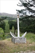 view gallery view galleryNW38.3 km |  The Anchor at Pinders Pond — Roxburgh, New Zealand The Anchor at Pinders Pond — Roxburgh, New Zealand
in Anchors An anchor that is high and dry and well away from the ocean, a lake, or a navigable water has no history associated with it. posted by: Dunbar Loop location: South Island, New Zealand date approved: 11/21/2009 last visited: 04/29/2013 |
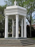 view gallery view gallery SE40.9 km SE40.9 km
|  Bruce Fallen Soldier Memorial - Milton, New Zealand Bruce Fallen Soldier Memorial - Milton, New Zealand
in World War I Memorials and Monuments War memorial placed in the former Bruce district in Milton to honor the fallen of World War I, additional inscriptions were added for World War II. posted by:  BruceS BruceS location: South Island, New Zealand date approved: 02/02/2013 last visited: 12/13/2014 |
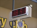 view gallery view gallerySE41 km |  Lions Club Clock - Milton. South Is. New Zealand. Lions Club Clock - Milton. South Is. New Zealand.
in Lions Clubs International Markers A Lions Club Marker above an electronic clock/temperature which has been gifted to the Milton District by the Lions Club of Milton. There is a brass plaque as well as the usual LIONS L INTERNATIONAL marker sign. posted by:  Punga and Paua Punga and Paua location: North Island, New Zealand date approved: 11/15/2010 last visited: 01/07/2013 |
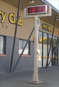 view gallery view gallerySE41 km |  Milton Time and Temp Sign. Milton. New Zealand. Milton Time and Temp Sign. Milton. New Zealand.
in Time and Temperature Signs A Time and Temperature Sign in the main street of the South Island town of Milton. posted by: Punga and Paua location: South Island, New Zealand date approved: 12/02/2009 last visited: 08/07/2013 |
 view gallery view galleryNW41 km | John Bennetts — Roxburgh, New Zealand in Citizen Memorials John Bennetts was remembered when this road was named after him. However, the road has since changed names to Teviot Road but this plaque remains. posted by: Dunbar Loop location: South Island, New Zealand date approved: 03/16/2010 last visited: 04/29/2013 |
 view gallery view galleryNW41 km |  Roxburgh Bridge — Roxburgh, New Zealand Roxburgh Bridge — Roxburgh, New Zealand
in Arch Bridges A simple steel arch bridge crosses the Clutha River at Roxburgh. This is the third bridge to have crossed here. posted by: Dunbar Loop location: South Island, New Zealand date approved: 11/24/2009 last visited: 04/29/2013 |
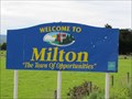 view gallery view gallerySE41.2 km |  Milton, New Zealand Milton, New Zealand
in Welcome Signs Welcome sign of the town of Milton "The Town of Opportunities" in south east of the South Island, New Zealand. posted by: BruceS location: South Island, New Zealand date approved: 02/02/2013 last visited: never |
 view gallery view galleryNW41.5 km |  Roxburgh Library Clock — Roxburgh, New Zealand Roxburgh Library Clock — Roxburgh, New Zealand
in Town Clocks Located on Scotland Street, Roxburgh's main street, the Library Clock keeps everyone on time in this sleepy town. posted by: Dunbar Loop location: South Island, New Zealand date approved: 11/21/2009 last visited: 11/16/2014 |
 view gallery view galleryNW41.5 km |  FIRST — Power Board Pole — Roxburgh, New Zealand FIRST — Power Board Pole — Roxburgh, New Zealand
in First of its Kind In celebration of the first power pole erected in Otago by an elected body of people, this commemorative sign was placed. Since then the power pole has been removed due to safety concerns. posted by: Dunbar Loop location: South Island, New Zealand date approved: 03/17/2010 last visited: 11/16/2014 |
 view gallery view gallery E41.7 km E41.7 km
| Bank of Otago — Outram, New Zealand in Converted Bank Buildings An agricultural centre Outram sported a handsome Bank of Otago building. posted by: Dunbar Loop location: South Island, New Zealand date approved: 03/28/2010 last visited: 07/15/2012 |
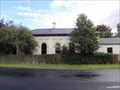
 view gallery view galleryNW41.8 km | 1926 — Sunday School — Roxburgh, New Zealand in Dated Buildings and Cornerstones This Sunday School was erected in 1926 to expand Christian education. posted by: Dunbar Loop location: South Island, New Zealand date approved: 03/20/2010 last visited: 11/16/2014 |
 view gallery view galleryNW45.4 km |  XXX on the highway — Roxburgh, New Zealand XXX on the highway — Roxburgh, New Zealand
in Themed Homemade Mailboxes Using an old milk canister this mailbox is now resembling a hootch jug. posted by: Dunbar Loop location: South Island, New Zealand date approved: 03/21/2010 last visited: 04/29/2013 |
 view gallery view galleryNW45.5 km | Roxburgh Dam, New Zealand in Ghost Towns The 1950s saw the rise and fall of this construction town. Reaching a peak of 3,078 people in 1954, there is nothing today at this location to remind people of the existence of this town other than this sign. posted by: Dunbar Loop location: South Island, New Zealand date approved: 11/24/2009 last visited: 04/29/2013 |
|