 view gallery view gallery S17.5 km S17.5 km
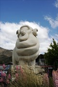
|   Omarama Merinos — Omarama, New Zealand Omarama Merinos — Omarama, New Zealand
in Figurative Public Sculpture The Omarama Merinos is a tribute to this breed of sheep that thrives in the area. posted by:  Dunbar Loop Dunbar Loop location: South Island, New Zealand date approved: 03/18/2010 last visited: 06/07/2012 |
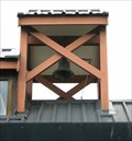 view gallery view galleryS17.7 km |  St Thomas Anglican Church — Omarama, New Zealand St Thomas Anglican Church — Omarama, New Zealand
in Bell Towers This modern church incorporates very traditional features including a bell tower. posted by: Dunbar Loop location: South Island, New Zealand date approved: 02/01/2010 last visited: 01/17/2015 |
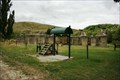
 view gallery view gallery SW22.5 km SW22.5 km
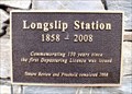
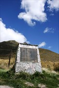
|  FIRST — Depasturing License was Issued — Longslip Station, New Zealand FIRST — Depasturing License was Issued — Longslip Station, New Zealand
in First of its Kind At the front gate of Longslip Station this plaque honours the first depasturing license issued to the sheep station in 1858. posted by: Dunbar Loop location: South Island, New Zealand date approved: 02/22/2010 last visited: never |
 view gallery view gallery NE23.8 km NE23.8 km
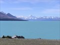
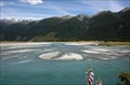
|  Lake Pukaki. South Is. New Zealand. Lake Pukaki. South Is. New Zealand.
in Natural Lakes Lake Pukaki, a glacial lake in the Mackenzie District has a stunning view across turquoise waters to Mt Cook rising at the northern end of the lake. posted by:  Punga and Paua Punga and Paua location: South Island, New Zealand date approved: 02/20/2012 last visited: 12/27/2022 |
 view gallery view gallerySW35.6 km | FIRST — Liberation of Red Deer in Otago — Lindis Pass, New Zealand in First of its Kind On the 100th anniversary of the first liberation of red deer in Otago, the New Zealand Deerstalkers Association erected this monument. It is reminder that most mammals in New Zealand are introduced species. posted by: Dunbar Loop location: South Island, New Zealand date approved: 11/23/2009 last visited: 02/21/2015 |
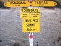 view gallery view gallerySW35.7 km |  Waitaki / Central Otago. New Zealand. Waitaki / Central Otago. New Zealand.
in Border Crossings This sign at Lindis Pass shows the boundary between the South Island districts of Waitaki and Central Otago. posted by: Punga and Paua location: South Island, New Zealand date approved: 05/13/2009 last visited: 05/13/2009 |
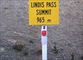 view gallery view gallerySW35.7 km |  Lindis Pass - 965 metres. South Island, New Zealand. Lindis Pass - 965 metres. South Island, New Zealand.
in Elevation Signs Lindis Pass, elevation 965 metres, lies between the towns of Cromwell and Omarama in Otago, on the main inland route to the Mackenzie Basin in Canterbury. posted by: Punga and Paua location: South Island, New Zealand date approved: 05/07/2009 last visited: 11/16/2009 |
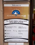 view gallery view galleryNE36.9 km | 677 Metres — Mackenzie District, New Zealand in Elevation Signs At 677 metres above sea level you will find the world's highest salmon farm. posted by: Dunbar Loop location: South Island, New Zealand date approved: 04/13/2010 last visited: never |
 view gallery view galleryNE36.9 km |  HIGHEST — Salmon Farm in the World — Mackenzie District, New Zealand HIGHEST — Salmon Farm in the World — Mackenzie District, New Zealand
in Superlatives Located on the Tekapo Canal you will find the highest salmon farm in the world. posted by: Dunbar Loop location: South Island, New Zealand date approved: 04/30/2010 last visited: 11/08/2009 |
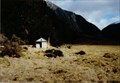 view gallery view gallery NW48.8 km NW48.8 km
|  Wills Hut - Wills Valley Wills Hut - Wills Valley
in Remote Backcountry Shelters Wills Valley Hut is part of the Mt Aspiring National Park posted by: StagsRoar location: South Island, New Zealand date approved: 12/21/2005 last visited: never |
 view gallery view galleryNW51.3 km | Westland - Otago Boundary on Haast Pass. South Is. New Zealand. in Border Crossings The border of Westland and Otago districts is crossed as you drive over the Haast Pass, a mountain pass in the Southern Alps linking the rugged West Coast of the South Island to the beautiful Wanaka Lake district in Central Otago. posted by: Punga and Paua location: South Island, New Zealand date approved: 09/19/2013 last visited: 01/17/2015 |
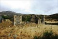 view gallery view gallery SE51.5 km SE51.5 km
|  Wharekuri, New Zealand Wharekuri, New Zealand
in Ghost Towns This ghost town features the remains of a hotel dating back to 1865. posted by: Dunbar Loop location: South Island, New Zealand date approved: 02/27/2010 last visited: 09/19/2011 |
 view gallery view gallerySW52.8 km |  Lindis Pass Hotel — Nine Mile, New Zealand Lindis Pass Hotel — Nine Mile, New Zealand
in Preserved Architectural Remnants and Ruins This stone hotel dates back the 1870s and served many purposes in the Nine Mile area -- general store, post office, school, and residence -- until 1951. posted by: Dunbar Loop location: South Island, New Zealand date approved: 03/03/2010 last visited: never |
 view gallery view gallerySW52.8 km |  Lindis Gold — Nine Mile, New Zealand Lindis Gold — Nine Mile, New Zealand
in Signs of History A descriptive panel discusses the history of gold rushes and human development in the Nine Mile area of Lindis Pass. posted by: Dunbar Loop location: South Island, New Zealand date approved: 03/04/2010 last visited: never |
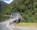 view gallery view galleryNW53.9 km |  Haast Pass - Southern Alps, Mount Aspiring National Park, New Zealand Haast Pass - Southern Alps, Mount Aspiring National Park, New Zealand
in Wikipedia Entries Haast Pass is a mountain pass in the Southern Alps of the South Island of New Zealand within Mount Aspiring National Park. posted by: denben location: South Island, New Zealand date approved: 01/27/2015 last visited: 02/05/2018 |
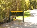 view gallery view gallery W54.4 km W54.4 km
|  Blue Pools Forest Walk - Mount Aspiring National Park, South Island, New Zealand Blue Pools Forest Walk - Mount Aspiring National Park, South Island, New Zealand
in Hiking and walking trailheads Access to the Blue Pools Forest walk is from the Blue Pools car park, off the Haast Highway (SH6) about 8 km from the township of Makarora on the West Coast of New Zealand. posted by: denben location: South Island, New Zealand date approved: 01/31/2015 last visited: never |
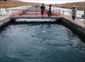
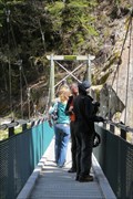 view gallery view galleryW54.9 km |  Blue Pools Swinging Bridge - Mount Aspiring National Park, South Island, New Zealand Blue Pools Swinging Bridge - Mount Aspiring National Park, South Island, New Zealand
in Pedestrian Suspension Bridges Access to the Blue Pools swinging bridge is from the Blue Pools car park, off the Haast Highway (SH6) about 8 km from the township of Makarora on the West Coast of New Zealand. posted by: denben location: South Island, New Zealand date approved: 01/28/2015 last visited: 01/28/2015 |
 view gallery view galleryNW55.8 km |  CONFLUENCE — Landsborough River - Haast River CONFLUENCE — Landsborough River - Haast River
in River Origins, Destinations and Confluences The Landsborough and Haast rivers meet at this scenic roadside pullout in Mt. Aspiring National Park. posted by: Dunbar Loop location: South Island, New Zealand date approved: 02/02/2010 last visited: 11/12/2010 |
 view gallery view gallerySE56.6 km |  Waitaki Dam — New Zealand Waitaki Dam — New Zealand
in Water Dams The Waitaki Dam was the last dam to built by pick and shovel in New Zealand. Built during the late 1920s and early 1930s it was the first dam to built in the Waitaki reservoir system. posted by: Dunbar Loop location: South Island, New Zealand date approved: 02/25/2010 last visited: 02/25/2010 |
 view gallery view galleryW56.6 km | Lake Hawea - Otago Region, New Zealand in Wikipedia Entries Lake Hawea is located in the Otago Region of New Zealand, at an altitude of 348 metres. Its name is Maori and is thought to be named after a local tribe though the exact meaning is uncertain. posted by: denben location: South Island, New Zealand date approved: 01/28/2015 last visited: 12/27/2022 |
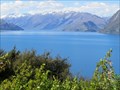 view gallery view galleryW56.6 km | Lake Hawea - Otago Region, New Zealand in Natural Lakes Lake Hawea is located in the Otago Region of New Zealand, at an altitude of 348 metres. Its name is Maori and is thought to be named after a local tribe though the exact meaning is uncertain. posted by: denben location: South Island, New Zealand date approved: 01/28/2015 last visited: 04/17/2024 |
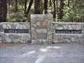
 view gallery view gallery N57.6 km N57.6 km
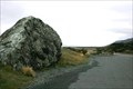
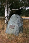
|  Pioneers Who First Established Road Access to the Mount Cook Region — Mt Cook Road, New Zealand Pioneers Who First Established Road Access to the Mount Cook Region — Mt Cook Road, New Zealand
in Citizen Memorials A plaque on a boulder beside the Mount Cook highway recognises the accomplishments of the early road builders to this region of New Zealand. posted by: Dunbar Loop location: South Island, New Zealand date approved: 04/09/2010 last visited: 12/10/2014 |
 view gallery view galleryNE58.1 km |  Dog Kennel Corner Memorial — Burkes Pass, New Zealand Dog Kennel Corner Memorial — Burkes Pass, New Zealand
in New Zealand Historic Places This New Zealand Historic Places Trust plaque reminds passersby of the importance of sheep dogs especially prior to the fencing of the high country. posted by: Dunbar Loop location: South Island, New Zealand date approved: 04/09/2010 last visited: 02/20/2011 |
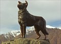 view gallery view galleryNE58.1 km |  Mackenzie Sheep Dog - South Island, New Zealand Mackenzie Sheep Dog - South Island, New Zealand
in Dog Statues The bronze statue of the dog on the shores of Lake Tekapo is dedicated to the working collie dogs of the Mackenzie Country and was commissioned on the 7th of March, 1968. posted by: Punga and Paua location: South Island, New Zealand date approved: 06/20/2008 last visited: 04/05/2013 |
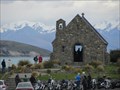 view gallery view galleryNE58.1 km |  Good Shepherd Waychapel, Tekapo, New Zealand Good Shepherd Waychapel, Tekapo, New Zealand
in Waychapels The Chapel of the Good Shepherd at Lake Tekapo is a favourite place to visit and photograph posted by: arby101ca location: South Island, New Zealand date approved: 12/16/2012 last visited: 12/27/2022 |
|