 view gallery view gallery S4 km S4 km
|   Mt John University Observatory. Tekapo. New Zealand. Mt John University Observatory. Tekapo. New Zealand.
in Astronomical Observatories Mt John Observatory is a high-tech research observatory, founded in 1965 as a joint project between the universities of Pennsylvania and Canterbury. It is at Lake Tekapo, in the centre of New Zealand’s South Island. posted by:  Punga and Paua Punga and Paua location: South Island, New Zealand date approved: 07/15/2009 last visited: 12/27/2022 |
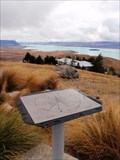
 view gallery view galleryS4.2 km |  1031 metres — Lake Tekapo, New Zealand 1031 metres — Lake Tekapo, New Zealand
in Elevation Signs At the centre of the Mount John Orientation Table is this elevation marker saying 1031 metres. posted by:  Dunbar Loop Dunbar Loop location: South Island, New Zealand date approved: 04/13/2010 last visited: never |
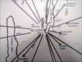
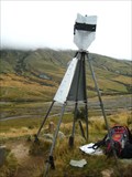
 view gallery view galleryS4.2 km |  Mt John Orientation Table — Lake Tekapo, New Zealand Mt John Orientation Table — Lake Tekapo, New Zealand
in Orientation Tables Near the Astro Cafe atop of Mt John is this orientation table. posted by: Dunbar Loop location: South Island, New Zealand date approved: 04/13/2010 last visited: never |
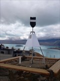 view gallery view galleryS4.2 km |  6702 MT JOHN — Lake Tekapo, New Zealand 6702 MT JOHN — Lake Tekapo, New Zealand
in Australia/NZ Benchmarks At the top of Mt. John amongst the observatory buildings you can find this trig site. posted by: Dunbar Loop location: South Island, New Zealand date approved: 04/13/2010 last visited: 12/27/2022 |
 view gallery view gallery SE6.4 km SE6.4 km
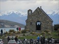
|  Good Shepherd Waychapel, Tekapo, New Zealand Good Shepherd Waychapel, Tekapo, New Zealand
in Waychapels The Chapel of the Good Shepherd at Lake Tekapo is a favourite place to visit and photograph posted by: arby101ca location: South Island, New Zealand date approved: 12/16/2012 last visited: 12/27/2022 |
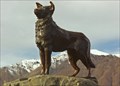 view gallery view gallerySE6.4 km |  Mackenzie Sheep Dog - South Island, New Zealand Mackenzie Sheep Dog - South Island, New Zealand
in Dog Statues The bronze statue of the dog on the shores of Lake Tekapo is dedicated to the working collie dogs of the Mackenzie Country and was commissioned on the 7th of March, 1968. posted by: Punga and Paua location: South Island, New Zealand date approved: 06/20/2008 last visited: 04/05/2013 |
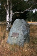 view gallery view gallerySE18.8 km |  Dog Kennel Corner Memorial — Burkes Pass, New Zealand Dog Kennel Corner Memorial — Burkes Pass, New Zealand
in New Zealand Historic Places This New Zealand Historic Places Trust plaque reminds passersby of the importance of sheep dogs especially prior to the fencing of the high country. posted by: Dunbar Loop location: South Island, New Zealand date approved: 04/09/2010 last visited: 02/20/2011 |
 view gallery view gallery SW23.5 km SW23.5 km
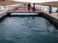
|  HIGHEST — Salmon Farm in the World — Mackenzie District, New Zealand HIGHEST — Salmon Farm in the World — Mackenzie District, New Zealand
in Superlatives Located on the Tekapo Canal you will find the highest salmon farm in the world. posted by: Dunbar Loop location: South Island, New Zealand date approved: 04/30/2010 last visited: 11/08/2009 |
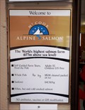 view gallery view gallerySW23.5 km | 677 Metres — Mackenzie District, New Zealand in Elevation Signs At 677 metres above sea level you will find the world's highest salmon farm. posted by: Dunbar Loop location: South Island, New Zealand date approved: 04/13/2010 last visited: never |
 view gallery view gallery NW30.3 km NW30.3 km
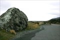
|  Pioneers Who First Established Road Access to the Mount Cook Region — Mt Cook Road, New Zealand Pioneers Who First Established Road Access to the Mount Cook Region — Mt Cook Road, New Zealand
in Citizen Memorials A plaque on a boulder beside the Mount Cook highway recognises the accomplishments of the early road builders to this region of New Zealand. posted by: Dunbar Loop location: South Island, New Zealand date approved: 04/09/2010 last visited: 12/10/2014 |
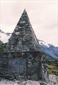
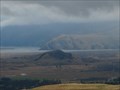
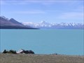 view gallery view gallerySW36.4 km |  Lake Pukaki. South Is. New Zealand. Lake Pukaki. South Is. New Zealand.
in Natural Lakes Lake Pukaki, a glacial lake in the Mackenzie District has a stunning view across turquoise waters to Mt Cook rising at the northern end of the lake. posted by: Punga and Paua location: South Island, New Zealand date approved: 02/20/2012 last visited: 12/27/2022 |
 view gallery view galleryNW37.3 km |  Aoraki/Mount Cook National Park - New Zealand Aoraki/Mount Cook National Park - New Zealand
in National Parks of the World Aoraki/Mount Cook was formally established as a national park in 1953. posted by: DougK location: South Island, New Zealand date approved: 06/02/2011 last visited: 12/27/2022 |
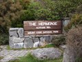
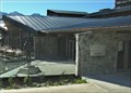 view gallery view galleryNW37.3 km |  Sir Edmund Hillary Alpine Centre Planetarium - Mt Cook, New Zealand Sir Edmund Hillary Alpine Centre Planetarium - Mt Cook, New Zealand
in Planetariums A Planetarium in the Sir Edmund Hillary Alpine Centre is located adjacent to The Hermitage Hotel in the majestic Aoraki Mount Cook National Park. posted by: Punga and Paua location: South Island, New Zealand date approved: 07/13/2009 last visited: 12/27/2022 |
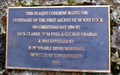 view gallery view galleryNW37.5 km |  FIRST — Ascent of Mount Cook — Mt Cook Village, New Zealand FIRST — Ascent of Mount Cook — Mt Cook Village, New Zealand
in First of its Kind At 3,754 metres Mt Cook, or in Maori, Aoraki, is the highest point of land in New Zealand. On Christmas Day 1894 the mountain was first climbed to the peak by three men. This plaque honours that moment in mountaineering history. posted by: Dunbar Loop location: South Island, New Zealand date approved: 04/13/2010 last visited: never |
 view gallery view galleryNW37.5 km | Jack Clarke, Tom Fyfe, & George Graham — Mt Cook Village, New Zealand in Citizen Memorials On Christmas Day 1894 Jack Clarke, Tom Fyfe, & George Graham were the first mountaineers to scale Aoraki/Mt Cook, which summit is at 3,754 metres. posted by: Dunbar Loop location: South Island, New Zealand date approved: 04/13/2010 last visited: never |
 view gallery view galleryNW37.5 km | 760 Metres — Mt Cook Village, New Zealand in Elevation Signs In the grounds of The Hermitage Hotel you'll find this sign giving the elevation as 760 metres. posted by: Dunbar Loop location: South Island, New Zealand date approved: 04/13/2010 last visited: never |
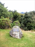
 view gallery view galleryNW38.3 km | Climbers Memorial. Mt Cook National Park. South Is. New Zealand. in Citizen Memorials A tall stone monument now serves as a memorial to all those who perished in Mount Cook National Park. The original plaque remembers the first fatal accident when three men were caught in an avalanche on Linda Glacier in 1914. posted by: Punga and Paua location: South Island, New Zealand date approved: 05/06/2010 last visited: 12/27/2022 |
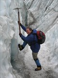
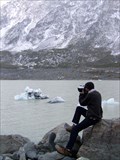 view gallery view galleryNW40.4 km |  Hooker Glacier, Aoraki/Mount Cook, New Zealand Hooker Glacier, Aoraki/Mount Cook, New Zealand
in Glaciers 4 hours return walk from Mt Cook resort on formed trails. The co-ords are to the terminal lake. Awe inspiring geology: moraine-terminal & lateral, hanging lakes, truncated spurs. A geology lesson in all its violent beauty. Cross 2 suspension bridges. posted by: SamWalkers location: South Island, New Zealand date approved: 09/17/2009 last visited: 04/07/2013 |
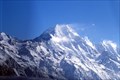
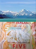 view gallery view galleryNW45.1 km |  Mt Cook. South Island. New Zealand. Mt Cook. South Island. New Zealand.
in Numismatic Photographs New Zealand's highest mountain, Mt Cook, features on the front of the orange $5 note beside the face of notable New Zealander Sir Edmund Hillary. posted by: Punga and Paua location: South Island, New Zealand date approved: 11/25/2011 last visited: 12/27/2022 |
  N48.4 km N48.4 km
|  Kelman Hut AKA "the Kelmanator" Kelman Hut AKA "the Kelmanator"
in Remote Backcountry Shelters Kelman Hut is found up on the Tasman Saddle at the head of the Tasman Glacier posted by: Team Volley location: South Island, New Zealand date approved: 04/26/2006 last visited: never |
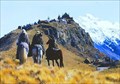 view gallery view gallery NE57.1 km NE57.1 km
|  EDORAS - Lord of The Rings Trilligy - The Two Towers EDORAS - Lord of The Rings Trilligy - The Two Towers
in Movie Locations Location Where peter jackson Filmed The Two Towers - Edoras
Offically Known as Mt. Sunday,
43.548317, 170.893183 posted by: deeregal location: New Zealand date approved: 09/16/2012 last visited: 10/19/2007 |
 view gallery view galleryNE57.9 km | AAD0 Mt Sunday - New Zealand in Australia/NZ Benchmarks This Site was used for the Lord of the Rings Film,
[ Mt Edoras] The Trig plates have been signed with initials or names of those who have visited,it seems two of the plates are now missing. posted by: Norfolk12 location: South Island, New Zealand date approved: 04/29/2010 last visited: never |
 view gallery view galleryNE57.9 km |  Lord of the Rings-location guidebook Lord of the Rings-location guidebook
in There's a Book About It This is the setting for the Castle Edoras,as described on pages 54 and 55.after filming all had to be returned back to the original condition. posted by: Norfolk12 location: South Island, New Zealand date approved: 07/09/2009 last visited: 03/05/2019 |
 view gallery view galleryN58.1 km | Franz Josef Glacier in Glaciers Ice is as Blue as a Snurf posted by: deeregal location: South Island, New Zealand date approved: 03/29/2008 last visited: 03/16/2024 |
 view gallery view gallerySE61 km | FIRST — Powered Flight to Be Made By a British Citizen in a Heavier Than Air Machine — Upper Waitohi, New Zealand in First of its Kind Richard Pearse took to the air in a monoplane on March 31st, 1903 making him the first British citizen to fly a a heavier than air machine. posted by: Dunbar Loop location: South Island, New Zealand date approved: 04/08/2010 last visited: 06/02/2016 |
|