 view gallery view gallery W2.4 km W2.4 km
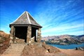
|   Rhodes Spring. Christchurch - New Zealand Rhodes Spring. Christchurch - New Zealand
in Fountains Rhodes Spring, on the scenic Summit Road on the Port Hills above Christchurch posted by:  waiiti20 waiiti20 location: South Island, New Zealand date approved: 10/13/2015 last visited: 10/03/2015 |
 view gallery view gallery N7.7 km N7.7 km
|  Sign of The Takahe Restaurant. Christchurch. New Zealand. Sign of The Takahe Restaurant. Christchurch. New Zealand.
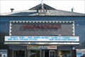
in Historic Eats A popular tourist attraction, The Sign of The Takahe Signature Restaurant is one of New Zealand's oldest restaurants with over sixty years of experience, located in an historic roadhouse set high in the Port Hills overlooking the city of Christchurch posted by: Punga and Paua location: North Island, New Zealand date approved: 08/15/2010 last visited: 10/03/2015 |
 view gallery view gallery NE7.7 km NE7.7 km
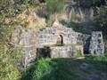
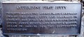
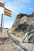
|  FIRST — Jetty on Erskine Bay — Lyttleton, New Zealand FIRST — Jetty on Erskine Bay — Lyttleton, New Zealand
in First of its Kind Prior to arrival of the settler ships to Canterbury, the Canterbury Association had to create infrastructure to ensure a smooth arrival, including building this jetty on Erskine Bay which ultimately lead to the development of Lyttleton. posted by:  Dunbar Loop Dunbar Loop location: South Island, New Zealand date approved: 04/13/2010 last visited: never |
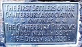 view gallery view galleryNE7.7 km | FIRST — Settlers of the Canterbury Association — Lyttleton, New Zealand in First of its Kind In 1850 the first settlers arrived in New Zealand under the Canterbury Association's initiative. This event is honoured at Pilgrim Rock. posted by: Dunbar Loop location: South Island, New Zealand date approved: 04/10/2010 last visited: never |
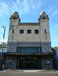 view gallery view galleryNE7.9 km |  Harbour Light Theatre — Lyttleton, New Zealand Harbour Light Theatre — Lyttleton, New Zealand
in Vintage Movie Theaters Built in 1916 the Harbour Light Theatre served as a cinema and live theatre until 1982 when it stopped showing movies. In 1992 it was converted into its present format of being a live performance venue and light cafe. posted by: Dunbar Loop location: South Island, New Zealand date approved: 04/13/2010 last visited: 02/06/2012 |
 view gallery view galleryNE7.9 km |  Centennial Memorial to the Pioneer Women of Canterbury — Summit Road, Christchurch, New Zealand Centennial Memorial to the Pioneer Women of Canterbury — Summit Road, Christchurch, New Zealand
in Citizen Memorials Located the summit of the Bridal Path the Memorial to the Pioneer Women recalls the arduous climb 340 metres | 1100 feet that all settlers had to walk from Lyttleton to here and then just as steeply down to Ferrymead. posted by: Dunbar Loop location: South Island, New Zealand date approved: 04/13/2010 last visited: never |
 view gallery view galleryNE7.9 km |  Lyttelton Timeball Station — Lyttleton, New Zealand Lyttelton Timeball Station — Lyttleton, New Zealand
in New Zealand Historic Places The Timeball Station was in important part of the mariners life well before GPS units of today. The black ball at the top would descend everyday at the same time thus enabling ship's captains to set their chronometers. posted by: Dunbar Loop location: South Island, New Zealand date approved: 04/11/2010 last visited: 12/31/2010 |
 view gallery view galleryNE8.2 km |  LARGEST — Port in the South Island — Lyttleton, New Zealand LARGEST — Port in the South Island — Lyttleton, New Zealand
in Superlatives Lyttleton Harbour is the largest seaport on the South Island. Primarily its tonnage comes from coal exports to Japan. However, it handles a wide range of commodities from around the world. posted by: Dunbar Loop location: South Island, New Zealand date approved: 04/30/2010 last visited: never |
 view gallery view galleryNE8.2 km | Laurie Jones — Lyttleton, New Zealand in Citizen Memorials A simple plaque at the base of fence honouring Laurie Jones. posted by: Dunbar Loop location: South Island, New Zealand date approved: 04/13/2010 last visited: never |
 view gallery view galleryNE10.1 km | Captain Joseph Thomas — Lyttleton, New Zealand in Citizen Memorials In the late 1840s the Canterbury Association wanted to develop a colony in New Zealand. They entrusted the initial laying of the site for the colony and planning of the infrastructure to Joseph Thomas and his crew. posted by: Dunbar Loop location: South Island, New Zealand date approved: 04/13/2010 last visited: never |
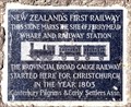 view gallery view galleryNE10.9 km | FIRST — Railway in New Zealand — Christchurch, New Zealand in First of its Kind At Ferrymead the first railway was built to connect this community with Christchurch. posted by: Dunbar Loop location: South Island, New Zealand date approved: 04/09/2010 last visited: never |
 view gallery view galleryN11.3 km |  Christchurch South Community Gardens - Christchurch, New Zealand Christchurch South Community Gardens - Christchurch, New Zealand
in Community Gardens The gardens have developed since 1999 on a council site into a multi-purpose community resource thanks to the generosity of Christchurch South Community Gardens Trust board and staff, local residents, council, funders and volunteers. posted by: waiiti20 location: South Island, New Zealand date approved: 07/15/2015 last visited: 07/03/2015 |
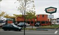 view gallery view galleryN12.2 km |  Denny's - Moorhouse Avenue - Christchurch, New Zealand Denny's - Moorhouse Avenue - Christchurch, New Zealand
in Denny's Restaurants This is the only Denny's located on the South Island and quite possibly the southernmost location in the world. posted by: Dunbar Loop location: South Island, New Zealand date approved: 04/09/2010 last visited: 07/04/2015 |
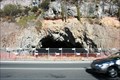 view gallery view galleryNE12.2 km | ") Te Ana o Hineraki | Moa Bone Point Cave — Christchurch, New Zealand Te Ana o Hineraki | Moa Bone Point Cave — Christchurch, New Zealand
in Cave Entrances (Natural) This large and deep cave's entrance is immediately beside the main road to Sumner. Currently it is fenced off as it is a cultural significant site for the Ngai Tahu Maori. posted by: Dunbar Loop location: South Island, New Zealand date approved: 04/17/2010 last visited: never |
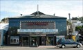 view gallery view galleryNE12.7 km | Hollywood Cinema — Christchurch, New Zealand in Vintage Movie Theaters The Hollywood Cinema feature three screens and is very popular with the residents of Sumner. Many of the restaurants and cafes along Marriner Street offer dinner-and-movie meals timed for your flick. posted by: Dunbar Loop location: South Island, New Zealand date approved: 04/13/2010 last visited: never |
 view gallery view galleryNE12.7 km |  Hollywood Cinema — Christchurch, New Zealand Hollywood Cinema — Christchurch, New Zealand
in Neon Signs The Hollywood 3 Cinema in the Sumner suburb of Christchurch features a simple neon sign. posted by: Dunbar Loop location: South Island, New Zealand date approved: 04/13/2010 last visited: never |
 view gallery view galleryNE12.7 km |  43° 34' S, 172° 45' E — Christchurch, New Zealand 43° 34' S, 172° 45' E — Christchurch, New Zealand
in Permanent Geographic Coordinates The Sumner Sundial features an orientation table in it. As if very common for sundials in New Zealand it also features the latitude and longitude, however rough, for the location. posted by: Dunbar Loop location: South Island, New Zealand date approved: 04/13/2010 last visited: never |
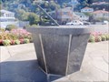 view gallery view galleryNE12.7 km |  Sumner Sundial — Christchurch, New Zealand Sumner Sundial — Christchurch, New Zealand
in Sundials A simple sundial in a roadside reserve in Sumner. posted by: Dunbar Loop location: South Island, New Zealand date approved: 04/13/2010 last visited: never |
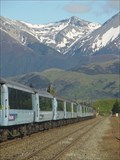 view gallery view galleryN12.7 km |  TranzAlpine. South Island. New Zealand. TranzAlpine. South Island. New Zealand.
in Scenic Railroads The TranzAlpine – travelling between Christchurch and Greymouth through the magnificent Southern Alps, is rated one of the world’s great scenic railway journeys. posted by: Punga and Paua location: South Island, New Zealand date approved: 08/28/2008 last visited: 02/28/2009 |
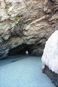 view gallery view galleryNE12.9 km | Cave Rock — Christchurch, New Zealand in Cave Entrances (Natural) Cave Rock is a large rock on the Sumner foreshore feature a large sea cave where people can walk through without bending. posted by: Dunbar Loop location: South Island, New Zealand date approved: 04/17/2010 last visited: 03/24/2024 |
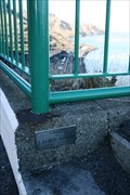
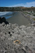 view gallery view galleryNE12.9 km |  CAVE ROCK — Christchurch, New Zealand CAVE ROCK — Christchurch, New Zealand
in Australia/NZ Benchmarks Located at the top of Cave Rock this benchmark overlooks Sumner Beach. posted by: Dunbar Loop location: South Island, New Zealand date approved: 04/09/2010 last visited: 03/24/2024 |
 view gallery view galleryNE12.9 km | Joseph Day — Christchurch, New Zealand in Citizen Memorials A pilot based in Sumner saved some 26 people during his career. posted by: Dunbar Loop location: South Island, New Zealand date approved: 04/09/2010 last visited: 11/10/2009 |
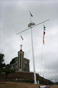
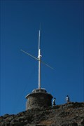
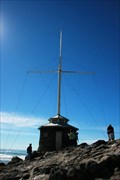 view gallery view galleryNE12.9 km |  Joseph Day Memorial Flag Pole — Christchurch, New Zealand Joseph Day Memorial Flag Pole — Christchurch, New Zealand
in Nautical Flag Poles Atop Cave Rock the Joseph Day Memorial recognises a pilot of Sumner, who, in a career spanning from 1869 until 1913, saved 26 people. posted by: Dunbar Loop location: South Island, New Zealand date approved: 04/09/2010 last visited: 03/24/2024 |
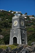 view gallery view galleryNE12.9 km |  Scarborough Clock Tower — Christchurch, New Zealand Scarborough Clock Tower — Christchurch, New Zealand
in Town Clocks Erected in 1934 to the memory of Edmund Green by his son Richard Edward Green, this clock stands over the Sumner Beach and recalls Edmund Green came to New Zealand to establish the first telegraph system. posted by: Dunbar Loop location: South Island, New Zealand date approved: 04/16/2010 last visited: 03/23/2021 |
 view gallery view galleryNE12.9 km | FIRST — Telegraph System in New Zealand — Christchurch, New Zealand in First of its Kind Edmund Green arrived in New Zealand in 1859 to build the nation's first telegraph system. In 1934 his built this clock tower in his honour and "to perpetuate the name of his father". posted by: Dunbar Loop location: South Island, New Zealand date approved: 04/16/2010 last visited: never |
|