 view gallery view gallery S0.6 km S0.6 km
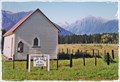
|   Our Lady of the River - Jacobs River, West Coast, New Zealand Our Lady of the River - Jacobs River, West Coast, New Zealand
in Anglican and Episcopal Churches A picturesque little church on the roadside is named Our Lady Of The River, on the main West Coast road at Jacobs River. posted by:  Punga and Paua Punga and Paua location: South Island, New Zealand date approved: 01/29/2015 last visited: 03/13/2018 |
 view gallery view gallery NE27.2 km NE27.2 km
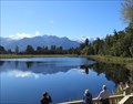
|  Lake Matheson - South Westland, New Zealand Lake Matheson - South Westland, New Zealand
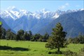
in Natural Lakes Famous for mirror views of Mount Tasman and Aoraki/Mount Cook, Lake Matheson is located in the Westland Tai Poutini National Park on the West Coast of New Zealand. posted by:  denben denben location: South Island, New Zealand date approved: 01/27/2015 last visited: 02/07/2018 |
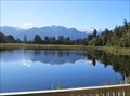 view gallery view galleryNE27.2 km |  Lake Matheson - South Westland, New Zealand Lake Matheson - South Westland, New Zealand
in Wikipedia Entries Famous for mirror views of Mount Tasman and Aoraki/Mount Cook, Lake Matheson is located in the Westland Tai Poutini National Park on the West Coast of New Zealand. posted by: denben location: South Island, New Zealand date approved: 01/26/2015 last visited: 11/22/2016 |
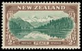 view gallery view galleryNE27.2 km |  Lake Matheson, New Zealand Lake Matheson, New Zealand
in Philatelic Photographs The 1946 Peace Stamp Series included the view of Mt Cook, Mt Tasman and the Fox Glacier reflected in Lake Matheson posted by: arby101ca location: South Island, New Zealand date approved: 12/20/2012 last visited: 11/22/2016 |
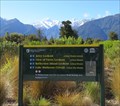 view gallery view galleryNE27.2 km |  Jetty Lookout Walk Trailhead - Lake Matheson, South Westland, New Zealand Jetty Lookout Walk Trailhead - Lake Matheson, South Westland, New Zealand
in Hiking and walking trailheads The Jetty Lookout Walk trailhead is located near the Lake Matheson Car Park in South Westland, New Zealand. posted by: denben location: South Island, New Zealand date approved: 01/31/2015 last visited: 11/22/2016 |
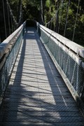 view gallery view galleryNE27.2 km |  Clearwater River Suspension Bridge - South Westland, New Zealand Clearwater River Suspension Bridge - South Westland, New Zealand
in Pedestrian Suspension Bridges Clearwater River Suspension Bridge is located about 130 m from the Lake Matheson Car Park in South Westland, New Zealand. posted by: denben location: South Island, New Zealand date approved: 01/26/2015 last visited: 02/02/2015 |
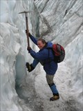
 view gallery view galleryNE29.8 km |  Fox Glacier Fox Glacier
in Glaciers A valley glacier in the south of New Zealand. posted by: Team_Tramper location: South Island, New Zealand date approved: 05/10/2006 last visited: 03/16/2024 |
 view gallery view gallery E36.2 km E36.2 km
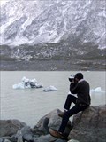
| Hooker Glacier, Aoraki/Mount Cook, New Zealand in Glaciers 4 hours return walk from Mt Cook resort on formed trails. The co-ords are to the terminal lake. Awe inspiring geology: moraine-terminal & lateral, hanging lakes, truncated spurs. A geology lesson in all its violent beauty. Cross 2 suspension bridges. posted by: SamWalkers location: South Island, New Zealand date approved: 09/17/2009 last visited: 04/07/2013 |
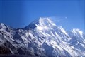
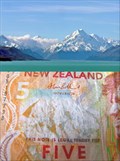 view gallery view galleryE36.7 km |  Mt Cook. South Island. New Zealand. Mt Cook. South Island. New Zealand.
in Numismatic Photographs New Zealand's highest mountain, Mt Cook, features on the front of the orange $5 note beside the face of notable New Zealander Sir Edmund Hillary. posted by: Punga and Paua location: South Island, New Zealand date approved: 11/25/2011 last visited: 12/27/2022 |
 view gallery view gallery SE37.3 km SE37.3 km
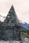
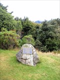
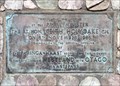
|  Climbers Memorial. Mt Cook National Park. South Is. New Zealand. Climbers Memorial. Mt Cook National Park. South Is. New Zealand.
in Citizen Memorials A tall stone monument now serves as a memorial to all those who perished in Mount Cook National Park. The original plaque remembers the first fatal accident when three men were caught in an avalanche on Linda Glacier in 1914. posted by: Punga and Paua location: South Island, New Zealand date approved: 05/06/2010 last visited: 12/27/2022 |
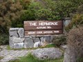 view gallery view gallerySE37.8 km |  760 Metres — Mt Cook Village, New Zealand 760 Metres — Mt Cook Village, New Zealand
in Elevation Signs In the grounds of The Hermitage Hotel you'll find this sign giving the elevation as 760 metres. posted by: Dunbar Loop location: South Island, New Zealand date approved: 04/13/2010 last visited: never |
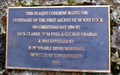 view gallery view gallerySE37.8 km |  FIRST — Ascent of Mount Cook — Mt Cook Village, New Zealand FIRST — Ascent of Mount Cook — Mt Cook Village, New Zealand
in First of its Kind At 3,754 metres Mt Cook, or in Maori, Aoraki, is the highest point of land in New Zealand. On Christmas Day 1894 the mountain was first climbed to the peak by three men. This plaque honours that moment in mountaineering history. posted by: Dunbar Loop location: South Island, New Zealand date approved: 04/13/2010 last visited: never |
 view gallery view gallerySE37.8 km | Jack Clarke, Tom Fyfe, & George Graham — Mt Cook Village, New Zealand in Citizen Memorials On Christmas Day 1894 Jack Clarke, Tom Fyfe, & George Graham were the first mountaineers to scale Aoraki/Mt Cook, which summit is at 3,754 metres. posted by: Dunbar Loop location: South Island, New Zealand date approved: 04/13/2010 last visited: never |
 view gallery view gallerySE37.8 km |  Sir Edmund Hillary Alpine Centre Planetarium - Mt Cook, New Zealand Sir Edmund Hillary Alpine Centre Planetarium - Mt Cook, New Zealand
in Planetariums A Planetarium in the Sir Edmund Hillary Alpine Centre is located adjacent to The Hermitage Hotel in the majestic Aoraki Mount Cook National Park. posted by: Punga and Paua location: South Island, New Zealand date approved: 07/13/2009 last visited: 12/27/2022 |
 view gallery view gallerySE38 km |  Aoraki/Mount Cook National Park - New Zealand Aoraki/Mount Cook National Park - New Zealand
in National Parks of the World Aoraki/Mount Cook was formally established as a national park in 1953. posted by: DougK location: South Island, New Zealand date approved: 06/02/2011 last visited: 12/27/2022 |
 view gallery view gallery SW39.9 km SW39.9 km
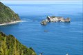
|  Knights Point Lookout - South Island, New Zealand Knights Point Lookout - South Island, New Zealand
in Scenic Roadside Look-Outs Knights Point lookout is located on South Island Highway 6 on the West Coast of New Zealand. It offers a scenic view of the coastline. posted by: denben location: South Island, New Zealand date approved: 01/28/2015 last visited: 02/05/2018 |
 view gallery view gallerySW39.9 km |  Paringa-Haast section of Highway 6 - South Island, New Zealand Paringa-Haast section of Highway 6 - South Island, New Zealand
in Grand Opening An obelisque and a plaque commemorating the inauguration of the Paringa-Haast section of Highway 6 is located at the Knights Point lookout on South Island Highway 6. posted by: denben location: South Island, New Zealand date approved: 01/27/2015 last visited: 02/04/2015 |
 view gallery view galleryE42.6 km | Franz Josef Glacier in Glaciers Ice is as Blue as a Snurf posted by: deeregal location: South Island, New Zealand date approved: 03/29/2008 last visited: 03/16/2024 |
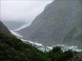
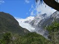 view gallery view galleryNE42.8 km |  Franz Josef Glacier - Westland Tai Poutini National Park, West Coast, New Zealand Franz Josef Glacier - Westland Tai Poutini National Park, West Coast, New Zealand
in Official Local Tourism Attractions The Franz Josef is a 12 km long glacier located in Westland Tai Poutini National Park on the West Coast of New Zealand's South Island. posted by: denben location: South Island, New Zealand date approved: 01/24/2015 last visited: 03/16/2024 |
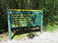 view gallery view galleryNE42.8 km | Franz Josef Glacier Walk Traihead - Westland Tai Poutini National Park, West Coast, New Zealand in Hiking and walking trailheads The Franz Josef Glacier Walk starts at the car park located at the end of Glacier Access Road in Westland Tai Poutini National Park on the West Coast of New Zealand. posted by: denben location: South Island, New Zealand date approved: 01/27/2015 last visited: 12/27/2022 |
 view gallery view galleryNE45.2 km |  Westland and Mount Cook National Parks - West Coast, New Zealand Westland and Mount Cook National Parks - West Coast, New Zealand
in World Heritage Sites Westland Tai Poutini and Aoraki/Mount Cook National Parks form part of Te Wahipounamu South Westland World Heritage Site. posted by: denben location: South Island, New Zealand date approved: 01/24/2015 last visited: 07/21/2015 |
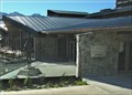
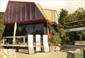 view gallery view galleryNE45.2 km |  Westland Tai Poutini National Park Visitor Centre - Franz Josef, West Coast, New Zealand Westland Tai Poutini National Park Visitor Centre - Franz Josef, West Coast, New Zealand
in Tourist Information Centers - Visitor Centers The Westland Tai Poutini National Park Visitor Centre is located on State Highway 6 in Franz Josef on the West Coast of New Zealand. posted by: denben location: South Island, New Zealand date approved: 01/28/2015 last visited: 07/21/2015 |
 view gallery view galleryNE45.2 km |  Defiance Hut - Franz Josef, West Coast, New Zealand Defiance Hut - Franz Josef, West Coast, New Zealand
in New Zealand Historic Places Defiance Hut is located behind the Westland Tai Poutini National Park Visitor Centre in Franz Josef on the West Coast of New Zealand. posted by: denben location: South Island, New Zealand date approved: 01/26/2015 last visited: 07/21/2015 |
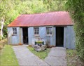 view gallery view galleryNE45.2 km |  Defiance Hut - Franz Josef, West Coast, New Zealand Defiance Hut - Franz Josef, West Coast, New Zealand
in Relocated Structures Cape Defiance Hut was relocated in 1978 behind the Westland Tai Poutini National Park Visitor Centre in Franz Josef on the West Coast of New Zealand. posted by: denben location: South Island, New Zealand date approved: 01/25/2015 last visited: 07/21/2015 |
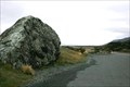 view gallery view gallerySE45.2 km | Pioneers Who First Established Road Access to the Mount Cook Region — Mt Cook Road, New Zealand in Citizen Memorials A plaque on a boulder beside the Mount Cook highway recognises the accomplishments of the early road builders to this region of New Zealand. posted by: Dunbar Loop location: South Island, New Zealand date approved: 04/09/2010 last visited: 12/10/2014 |
|