 view gallery view gallery E0.3 km E0.3 km
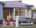
|   Garden of Legs. Sanson. New Zealand. Garden of Legs. Sanson. New Zealand.
in Junk Design Houses An interesting little house with some luscious-looking legs blooming in the front garden!
The legs have since been pruned a little, but all sorts of new things keep blossoming as time goes by. posted by:  Punga and Paua Punga and Paua location: North Island, New Zealand date approved: 08/07/2008 last visited: 07/23/2016 |
 view gallery view gallery SE0.5 km SE0.5 km
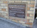
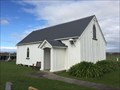
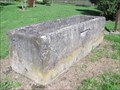
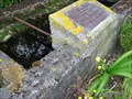
|  1950 - Cornerstone on Church converted to Cafe. Sanson. New Zealand. 1950 - Cornerstone on Church converted to Cafe. Sanson. New Zealand.
in Dated Buildings and Cornerstones A corner stone on a converted church in Sanson is dated 1950. posted by: Punga and Paua location: North Island, New Zealand date approved: 04/19/2010 last visited: 07/23/2016 |
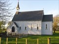
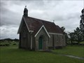
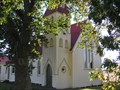 view gallery view gallerySE1.1 km |  St Thomas. Sanson. Rangitikei. New Zealand. St Thomas. Sanson. Rangitikei. New Zealand.
in This Old Church The beautiful old Anglican church of St Thomas stands on the corner of Main Street, Sanson. There is a monthly service at 9.30am on the fourth Sunday and a Carol Service on Christmas Eve. posted by: Punga and Paua location: North Island, New Zealand date approved: 04/19/2010 last visited: 07/23/2016 |
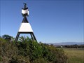
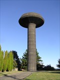 view gallery view gallery NW4.8 km NW4.8 km
|  Bulls Water Tower. Rangitikei. New Zealand. Bulls Water Tower. Rangitikei. New Zealand.
in Water Towers Looking like a huge UFO, the Bulls water tower is a well known landmark near SH1 through the central North Island. posted by: Punga and Paua location: North Island, New Zealand date approved: 04/18/2010 last visited: 07/23/2016 |
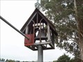 view gallery view galleryNW6 km |  St Andrews Church Bell Tower - Bulls, New Zealand St Andrews Church Bell Tower - Bulls, New Zealand
in Bell Towers A small bell tower located behind St Andrews Anglican Church in Bulls. posted by: No Fixed Aboder location: North Island, New Zealand date approved: 03/14/2010 last visited: 01/30/2016 |
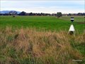
 view gallery view gallerySE6.6 km |  1231 Mt Stewart Marker. North Is. New Zealand. 1231 Mt Stewart Marker. North Is. New Zealand.
in Australia/NZ Benchmarks A geodetic survey mark beneath the trig on Mt Stewart, 19 km north-west of Palmerston North and 6 km south-east of Sanson. It was named after early surveyor John Tiffin Stewart, who chose the site for the station. posted by: Punga and Paua location: North Island, New Zealand date approved: 04/14/2010 last visited: 04/11/2010 |
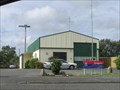 view gallery view gallery S8.4 km S8.4 km
|  Rongotea Volunteer Fire Brigade. Rongotea Volunteer Fire Brigade.
in Firehouses A small band of dedicated volunteers man the Rongotea Fire Station in the Manawatu countryside. posted by: Punga and Paua location: North Island, New Zealand date approved: 02/01/2011 last visited: 02/01/2011 |
 view gallery view gallery W8.4 km W8.4 km
| Wheriko (Jericho) Anglican Church - Parewanui, New Zealand in This Old Church Te Wheriko (Jericho) Church at Parewanui was consecrated by the Reverend Richard Taylor in 1862. Taylor had been an Anglican missionary to the Maori population in the Whanganui and Rangitikei areas from 1843. posted by: waiiti20 location: North Island, New Zealand date approved: 07/24/2016 last visited: 03/18/2024 |
 view gallery view gallery N10.1 km N10.1 km
| St Martin's Church, Greatford. North Is. New Zealand. in This Old Church Standing in the fields between the main trunk railway and the main road the charming St Martin's Church, built in 1882, is an enchanting sight from State Highway 1. posted by: Punga and Paua location: North Island, New Zealand date approved: 10/28/2009 last visited: 08/10/2018 |
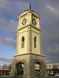 view gallery view galleryE12.6 km |  Feilding Clock Tower. Manawatu. New Zealand. Feilding Clock Tower. Manawatu. New Zealand.
in Town Clocks The iconic Clock Tower, a familiar landmark, stands in the Square in the center of Feilding. posted by: Punga and Paua location: New Zealand date approved: 08/07/2008 last visited: 06/10/2016 |
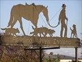 view gallery view galleryE12.7 km |  The Stockman, Feilding. New Zealand. The Stockman, Feilding. New Zealand.
in Silhouette Public Art Sculptures The Stockman with his horse and dogs is depicted in a flat sculpture standing high above the street outside the Saleyards in Feilding. posted by: Punga and Paua location: North Island, New Zealand date approved: 10/16/2010 last visited: 10/18/2010 |
 view gallery view galleryE16.7 km | A67U - BASE A in Australia/NZ Benchmarks Situated on road reserve beside State Highway 54 offers outlook views to Ruahine range across mixed stock farming. posted by: Phronimos location: North Island, New Zealand date approved: 06/10/2022 last visited: 08/08/2022 |
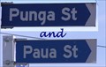 view gallery view gallery SW16.9 km SW16.9 km
|  Punga and Paua Street Signs. Tangimoana. Nth Is. New Zealand. Punga and Paua Street Signs. Tangimoana. Nth Is. New Zealand.
in Your Name Here In the small seaside community of Tangimoana you can find our Profile names Punga and Paua. posted by: Punga and Paua location: North Island, New Zealand date approved: 04/23/2008 last visited: 12/05/2009 |
 view gallery view galleryN21.4 km |  St Johns Anglican Church - Parish of Rangitikei, New Zealand St Johns Anglican Church - Parish of Rangitikei, New Zealand
in Anglican and Episcopal Churches A beautiful old country church which contains the grave of Bishop Octavius Hadfield who came out to NZ as a young man and missionary not really expecting to live a long life yet living 91 years, married and had a family, many who are also buried here posted by: waiiti20 location: South Island, New Zealand date approved: 12/16/2016 last visited: 12/16/2016 |
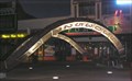
 view gallery view gallerySE22.2 km |  Guthrie Bowron. Palmerston North. New Zealand. Guthrie Bowron. Palmerston North. New Zealand.
in Artistic Neon Lights A bright new eye-catching Neon sign on the main road into Palmerston North. posted by: Punga and Paua location: North Island, New Zealand date approved: 10/14/2009 last visited: 10/11/2009 |
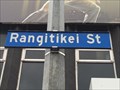 view gallery view gallerySE22.5 km |  Rangtikei St, New Zealand edition. Auckland - New Zealand Rangtikei St, New Zealand edition. Auckland - New Zealand
in Monopoly in the Real World Rangitiket Street is the major commercial thoroughfare in the Palmerston North posted by: waiiti20 location: New Zealand date approved: 08/25/2015 last visited: 08/25/2015 |
 view gallery view gallerySE22.5 km |  Numbers. Palmerston North. New Zealand. Numbers. Palmerston North. New Zealand.
in Abstract Public Sculptures "Numbers", by Anton Parsons.
The First sculpture commissioned by the Palmerston North Public Sculpture Trust. posted by: Punga and Paua location: North Island, New Zealand date approved: 10/12/2009 last visited: 08/23/2015 |
 SE22.7 km |  Palmies Horizon Palmies Horizon
in Web Cameras Local Councils locked off camera looking East from The Square posted by:  2CUL8TR 2CUL8TR location: New Zealand date approved: 09/10/2006 last visited: 02/24/2008 |
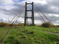 view gallery view galleryS24.3 km |  Opito Toll Bridge. Manawatu. New Zealand. Opito Toll Bridge. Manawatu. New Zealand.
in Orphaned Bridges In a former flax-growing area on State Highway 56, a distinctive abandoned suspension toll bridge operated from 1918 to 1969. posted by: Punga and Paua location: North Island, New Zealand date approved: 02/11/2010 last visited: 07/22/2015 |
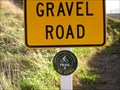
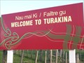 view gallery view galleryNW25.3 km |  Welcome to Turakina. Rangitikei. New Zealand. Welcome to Turakina. Rangitikei. New Zealand.
in Artistic Welcome Signs Turakina is a small village in the western Rangitikei district with a Maori name and yet it has distinct Scottish feel to it. The welcome sign combines Maori and Scottish traditions, cleverly joining Maori designs with a Scottish tartan pattern. posted by: Punga and Paua location: North Island, New Zealand date approved: 08/01/2011 last visited: 02/14/2021 |
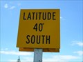 view gallery view galleryN25.6 km |  Latitude 40 South - Hunterville, North Island, New Zealand Latitude 40 South - Hunterville, North Island, New Zealand
in Great Lines of Earth A road sign informing motorists they have passed the 40 degrees South latitude. posted by: No Fixed Aboder location: North Island, New Zealand date approved: 02/17/2011 last visited: 12/30/2022 |
 view gallery view galleryNW25.7 km |  Historic Horse Water Trough. Turakina. New Zealand. Historic Horse Water Trough. Turakina. New Zealand.
in Historic Upping Stones, Hitching Posts, and Carriage Blocks An historic horse water trough stands in a roadside park in this picturesque small town of Turakina. posted by: Punga and Paua location: North Island, New Zealand date approved: 02/07/2011 last visited: 02/14/2021 |
 view gallery view gallerySE27.4 km | Linton Historic Horse Water Trough. Linton. New Zealand. in Historic Upping Stones, Hitching Posts, and Carriage Blocks An historic stone water trough on the corner of SH.57 was built in 1903 and used to provide water for horses and cattle travelling along this stock route in the Manawatu district. posted by: Punga and Paua location: North Island, New Zealand date approved: 11/09/2010 last visited: 03/13/2014 |
 view gallery view galleryN29.3 km |  Mt Curl Trail 3. near Marton. New Zealand. Mt Curl Trail 3. near Marton. New Zealand.
in Cycling Routes As part of the Gorges To Sea (gorgeous to see)Cycle Trails 1 to 4, the Mt Curl Trail 3 winds through countryside over scenic Mt Curl Road and into Marton. posted by: Punga and Paua location: North Island, New Zealand date approved: 08/10/2011 last visited: 08/10/2011 |
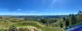 view gallery view gallery NE30.3 km NE30.3 km
|  Stormy Point Lookout. Rangitikei. North Is. New Zealand. Stormy Point Lookout. Rangitikei. North Is. New Zealand.
in Scenic Roadside Look-Outs On the Cheltenham/Hunterville Road, a lookout that gives stunning views of Mt Ruapehu And Mt Taranaki on a clear day. posted by: Punga and Paua location: North Island, New Zealand date approved: 05/13/2022 last visited: 09/07/2022 |
|