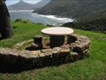
 view gallery view gallery S1.8 km S1.8 km
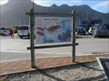
|   Rock Lobsters and Rocky Shores, Hout Bay, South Africa Rock Lobsters and Rocky Shores, Hout Bay, South Africa
in Flora and Fauna Information Signs This sign is near the entry driveway to the Marina area of Hout Bay. posted by:  Queens Blessing Queens Blessing location: Western Cape, South Africa date approved: 10/12/2013 last visited: 09/22/2014 |
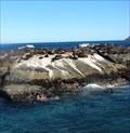 view gallery view galleryS1.9 km |  Chapman's Peak Drive - Boat Trip to Seal Island - Hout Bay, South Africa Chapman's Peak Drive - Boat Trip to Seal Island - Hout Bay, South Africa
in National Scenic Byways Hout Bay, on the scenic Chapman's Peak Drive, is a popular tourist attraction among both local and international visitors. The 45-minute Cruise to the seal colony and around the Sentinel Hill is an interesting activity. posted by:  denben denben location: Western Cape, South Africa date approved: 11/27/2013 last visited: 03/29/2017 |
 view gallery view galleryS1.9 km |  Boat Trip to Seal Island - Hout Bay, South Africa Boat Trip to Seal Island - Hout Bay, South Africa
in Official Local Tourism Attractions Hout Bay, on the scenic Chapman's Peak Drive, is a popular tourist attraction among both local and international visitors. The 45-minute Cruise to the seal colony and around the Sentinel Hill is an interesting activity. posted by: denben location: Western Cape, South Africa date approved: 11/25/2013 last visited: 10/20/2014 |
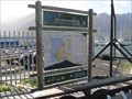
 view gallery view galleryS1.9 km |  Karbonkelberg, Hout Bay, South Africa Karbonkelberg, Hout Bay, South Africa
in 'You Are Here' Maps If you are standing in front of this sign, you will notice you are in South Africa. posted by: Queens Blessing location: Western Cape, South Africa date approved: 10/12/2013 last visited: 09/21/2019 |
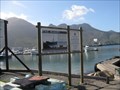
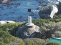
 view gallery view galleryS1.9 km |  National Sea Rescue Institute, Hout Bay, South Africa National Sea Rescue Institute, Hout Bay, South Africa
in Lifeboats and Rescue Stations This is the base for National Sea Rescue Institute branch #8, located in Hout Bay. posted by: Queens Blessing location: Western Cape, South Africa date approved: 10/13/2013 last visited: 10/20/2014 |
 view gallery view galleryS1.9 km |  Shipwreck of the Maori, Hout Bay, South Africa Shipwreck of the Maori, Hout Bay, South Africa
in Signs of History This sign gives the details of the wreck of the ship "Maori". posted by: Queens Blessing location: Western Cape, South Africa date approved: 10/13/2013 last visited: 10/20/2014 |
 view gallery view galleryS1.9 km |  Karbonkelberg, Table Mountain Natl Park, Hout Bay, South Africa Karbonkelberg, Table Mountain Natl Park, Hout Bay, South Africa
in National Parks of the World Karbonkelberg is a mountain on the Cape Peninsula which is part of the Table Mountain National Park. posted by: Queens Blessing location: Western Cape, South Africa date approved: 10/25/2013 last visited: 10/20/2014 |
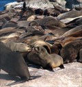
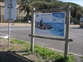 view gallery view galleryS1.9 km | Cape Fur Seal--A Species on the Rise, Hout Bay, South Africa in Flora and Fauna Information Signs Hout Bay is located on the Cape Peninsula in South Africa. This sign provides interesting information on the Cape Fur Seal. posted by: Queens Blessing location: Western Cape, South Africa date approved: 10/13/2013 last visited: 10/20/2014 |
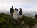
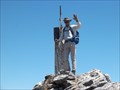 view gallery view gallery W2.1 km W2.1 km
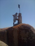
|  SUTHER PEAK - 3418-95 SUTHER PEAK - 3418-95
in Southern African Trig Beacons Beacon on top of Suthers Peak between Hout Bay and Llandudno posted by: tomtwogates location: Western Cape, South Africa date approved: 12/07/2017 last visited: 12/08/2017 |
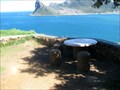
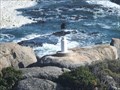
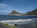 view gallery view gallery SE2.9 km SE2.9 km
|  Hout Bay, Cape Peninsula, South Africa Hout Bay, Cape Peninsula, South Africa
in Cityscapes This vantage point provides a gorgeous place to take a picture-postcard vacation photo. posted by: Queens Blessing location: Western Cape, South Africa date approved: 10/31/2013 last visited: 03/07/2024 |
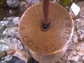
 view gallery view galleryW3.5 km | LS1 3418-93 in Southern African Trig Beacons This beacon is on tall rocks on Oude Schip near Sandy Bay - which is an island at high tide. posted by: tomtwogates location: Western Cape, South Africa date approved: 03/23/2013 last visited: 10/02/2012 |
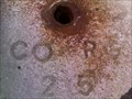
 view gallery view gallerySE3.7 km | CONSTANTIABG SUB1 3418-4 in Southern African Trig Beacons standard beacon posted by: jevan miell location: Western Cape, South Africa date approved: 07/08/2013 last visited: never |
 view gallery view gallerySE4 km | CONSTANTIABG SUB2 3418-5 in Southern African Trig Beacons standard beacon posted by: jevan miell location: Western Cape, South Africa date approved: 07/10/2013 last visited: never |
 view gallery view gallerySE4 km | CONSTANTIABERG 3418-3 in Southern African Trig Beacons standard beacon. posted by: jevan miell location: Western Cape, South Africa date approved: 07/08/2013 last visited: never |
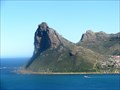
 view gallery view galleryS4.3 km |  Chapman's Peak Drive, Hout Bay, South Africa Chapman's Peak Drive, Hout Bay, South Africa
in Scenic Roadside Look-Outs This roadside look-out is on Chapman's Drive (also called highway M6). posted by: Queens Blessing location: Western Cape, South Africa date approved: 10/15/2013 last visited: 03/29/2017 |
 view gallery view gallery E4.5 km E4.5 km
| VLAKKENBERG - 3418-73 in Southern African Trig Beacons the highest point of Vlakkenberg which is the flat topped mountain between Constantiaberg Eagles Nest which is part of the back of Table Mountain posted by: tomtwogates location: Western Cape, South Africa date approved: 05/27/2014 last visited: 05/27/2014 |
 view gallery view galleryS4.5 km | Chapman's Peak Drive Lookout - Hout Bay, South Africa in Scenic Roadside Look-Outs Spectacular views of the Sentinel Hill and Hout Bay from the Chapman's Peak Drive lookout. posted by: denben location: Western Cape, South Africa date approved: 11/21/2013 last visited: 03/07/2024 |
 view gallery view galleryS4.5 km | Chapman's Peak Drive - Hout Bay and Sentinel Hill, South Africa in National Scenic Byways Spectacular views of the Sentinel Hill and Hout Bay from the Chapman's Peak Drive lookout. posted by: denben location: Western Cape, South Africa date approved: 11/24/2013 last visited: 03/07/2024 |
 view gallery view gallery N5 km N5 km
| LN II 3318-282 in Southern African Trig Beacons At Oudekraal beach near Llandudno. posted by: Fish Eagle location: Western Cape, South Africa date approved: 06/28/2017 last visited: 07/04/2017 |
 view gallery view galleryN5 km | LN I 3318-281 in Southern African Trig Beacons At Oudekraal beach near Llandudno. posted by: Fish Eagle location: Western Cape, South Africa date approved: 06/28/2017 last visited: 07/04/2017 |
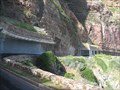 view gallery view galleryS5.3 km | Chapman's Peak Drive, Cape Peninsula, South Africa in National Scenic Byways This is one spectacular drive; don't miss the fabulous views and breathtaking highway engineering! posted by: Queens Blessing location: Western Cape, South Africa date approved: 10/12/2013 last visited: 11/10/2019 |
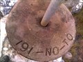 view gallery view gallerySE6 km | NOORDEHOEK PLATO 3418-191 in Southern African Trig Beacons standard beacon posted by: jevan miell location: Western Cape, South Africa date approved: 07/10/2013 last visited: 05/21/2022 |
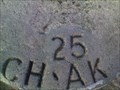 view gallery view galleryS6.1 km | CHAPMANS PEAK 3418-25 in Southern African Trig Beacons standard beacon posted by: jevan miell location: Western Cape, South Africa date approved: 07/08/2013 last visited: 07/29/2014 |
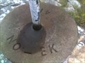 view gallery view gallerySE7.7 km | NOORDHOEK 3418-41 in Southern African Trig Beacons standard beacon posted by: jevan miell location: Western Cape, South Africa date approved: 07/09/2013 last visited: never |
 view gallery view galleryS7.7 km | GOEIE HOOP 3418-189 in Southern African Trig Beacons 0.3m beacon posted by: jevan miell location: Western Cape, South Africa date approved: 07/10/2013 last visited: never |
|