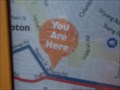
 view gallery view gallery NW0.5 km NW0.5 km
|   University of Newcastle - You are here - Callaghan, NSW, Australia University of Newcastle - You are here - Callaghan, NSW, Australia
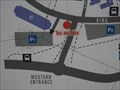
in 'You Are Here' Maps At the Western Entrance to the University of Newcastle is a 'Campus Information sign and map. showing where different Departments are, and where you are. posted by:  Grahame Cookie Grahame Cookie location: New South Wales, Australia date approved: 12/27/2017 last visited: never |
 view gallery view galleryNW0.5 km |  University of Newcastle, Callaghan Campus - Callaghan, NSW, Australia University of Newcastle, Callaghan Campus - Callaghan, NSW, Australia
in Universities and Colleges "The University of Newcastle Australia (UON) is a world-class university. Excellence in teaching, research and the student experience is the focus at UON". posted by: Grahame Cookie location: New South Wales, Australia date approved: 01/01/2018 last visited: never |
 view gallery view gallery W0.6 km W0.6 km
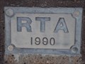
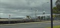
|  University Drive O/P Main Road - 1990 - Callaghan, NSW, Australia University Drive O/P Main Road - 1990 - Callaghan, NSW, Australia
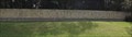
in Bridge Date Stones and Plaques This Round-about Overpass of University Drive, as a 'circular bridge' above Main Road (Newcastle Inner City Bypass) was built in 1990 to easily allow traffic to head to/past the University of Newcastle. posted by: Grahame Cookie location: New South Wales, Australia date approved: 01/01/2018 last visited: never |
 view gallery view galleryNW0.8 km |  Medical Sciences Building - 1978 - Callaghan, NSW, Australia Medical Sciences Building - 1978 - Callaghan, NSW, Australia
in Dated Architectural Structures Multifarious The Medical Sciences Building, of the University of Newcastle was built at the Callaghan campus, in 1978. posted by: Grahame Cookie location: New South Wales, Australia date approved: 01/16/2018 last visited: never |
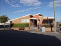
 view gallery view galleryW1 km |  KFC, Blue Gum Road - Jesmond, NSW, Australia KFC, Blue Gum Road - Jesmond, NSW, Australia
in Kentucky Fried Chicken/KFC Restaurants Beside the 'historic' Jesmond Shopping Centre, is this stand alone KFC outlet. Access is from Blue Gum Road, tho most commonly seen from the shopping centre car park. posted by: Grahame Cookie location: New South Wales, Australia date approved: 05/21/2018 last visited: never |
 view gallery view gallery SW1.1 km SW1.1 km
|  Jesmond Post Shop (Stockland S/C), NSW - 2299 Jesmond Post Shop (Stockland S/C), NSW - 2299
in Australia Post Offices This Post Shop is at the northern entrance to the Jesmond Stockland Shopping Centre - eastern side (a suburb of Newcastle). posted by: Grahame Cookie location: New South Wales, Australia date approved: 07/17/2017 last visited: never |
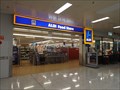
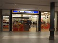 view gallery view gallerySW1.1 km |  ALDI Store - Stockland Shopping Centre, Jesmond, NSW, Australia ALDI Store - Stockland Shopping Centre, Jesmond, NSW, Australia
in ALDI Stores Set within the Jesmond Stockland Shopping Mall, this is a 'new' store addition to the Stockland Jesmond Shopping Centre, being opened in 2015. posted by: Grahame Cookie location: New South Wales, Australia date approved: 09/18/2016 last visited: never |
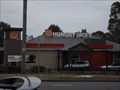 view gallery view gallerySW1.1 km |  Hungry Jacks, Blue Gum Rd - Jesmond, NSW, Australia Hungry Jacks, Blue Gum Rd - Jesmond, NSW, Australia
in Burger King Restaurants On the corner of Newcastle Road, with access from Blue Gum Road, is this very visible Hungry Jacks outlet, on a major arterial road of Newcastle. posted by: Grahame Cookie location: New South Wales, Australia date approved: 01/23/2018 last visited: never |
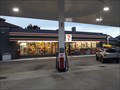 view gallery view gallery S1.4 km S1.4 km
|  7-Eleven, Croudace St, Lambton, NSW, Australia 7-Eleven, Croudace St, Lambton, NSW, Australia
in 7-Eleven Stores This Mobil service station on the A37 (aka Croudace Street), Lambton, is also the local 7-Eleven outlet. posted by: Grahame Cookie location: New South Wales, Australia date approved: 10/05/2017 last visited: never |
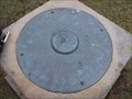 view gallery view gallery E1.6 km E1.6 km
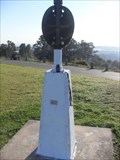
|  Braye Park Lookout - Waratah West, NSW, Australia Braye Park Lookout - Waratah West, NSW, Australia
in Orientation Tables At the Braye Park Lookout is a sandstone plinth, that has a Memorial Orientation Plate, dedicated to Ross Braye, who was Killed in Action, in Libya, on 26 December, 1941. posted by: Grahame Cookie location: New South Wales, Australia date approved: 12/27/2017 last visited: never |
 view gallery view galleryE1.6 km |  Ross Braye RAAF - Braye Park Lookout - Waratah, NSW, Australia Ross Braye RAAF - Braye Park Lookout - Waratah, NSW, Australia
in Specific Veteran Memorials While Braye Park at Waratah is dedicated to Ross Braye (RAAF) [no. 3 Squadron], who died in Libya, in 1941, there is an Orientation Plate on a sandstone plinth that recognises his service, and death, in World War 2. posted by: Grahame Cookie location: New South Wales, Australia date approved: 12/28/2017 last visited: never |
 view gallery view galleryE1.6 km |  Ross Braye - Braye Park L/O, Waratah West, NSW, Australia Ross Braye - Braye Park L/O, Waratah West, NSW, Australia
in Citizen Memorials The Orientation Table at Braye Park Lookout gives a partial explanation of the reason for the naming of the Bray Park Lookout - after Ross Braye, KIA in Libya, 1941. posted by: Grahame Cookie location: New South Wales, Australia date approved: 12/31/2017 last visited: never |
 view gallery view galleryE1.6 km |  Waratah, Newcastle, NSW Waratah, Newcastle, NSW
in Australian Trig Points Waratah is located in Braye Park west of Newcastle, NSW. posted by:  fathrtime fathrtime location: New South Wales, Australia date approved: 08/17/2011 last visited: 10/21/2014 |
 view gallery view gallerySW1.8 km |  Wallsend Brickworks Park Orienteering Course - Wallsend, NSW, Australia Wallsend Brickworks Park Orienteering Course - Wallsend, NSW, Australia
in Permanent Orienteering Courses This Permanent Orienteering Course is set up in the Wallsend Brickworks Park of Wallsend, west of Newcastle. posted by: Grahame Cookie location: New South Wales, Australia date approved: 01/04/2024 last visited: never |
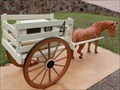 view gallery view gallerySW1.9 km |  Horse and Cart Mailbox - Wallsend, NSW, Australia Horse and Cart Mailbox - Wallsend, NSW, Australia
in Themed Homemade Mailboxes This is quite an unusually themed Mailbox for the urban house. posted by: Grahame Cookie location: New South Wales, Australia date approved: 01/21/2024 last visited: never |
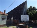 view gallery view galleryW2.1 km |  Wallsend Multicultural SDA, Wallsend, NSW, Australia Wallsend Multicultural SDA, Wallsend, NSW, Australia
in Seventh-day Adventist Churches This church has a distinctive raked, high-pitched roof, that had outlined the area for many years (until the trees have almost obscured it). posted by: Grahame Cookie location: New South Wales, Australia date approved: 11/12/2016 last visited: never |
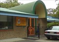
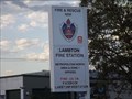 view gallery view gallery SE2.6 km SE2.6 km
|  Lambton Fire Station Lambton Fire Station
in Firehouses This is a NEW fire station for the close western suburbs of Newcastle, and combines the Lambton, New Lambton, and Hamilton Stations. Yippee, it does have a Fire Pole! posted by: Grahame Cookie location: New South Wales, Australia date approved: 01/01/2018 last visited: never |
 view gallery view gallerySE2.9 km | Bus Stop - You Are Here - Lambton, NSW, Australia in 'You Are Here' Maps At the Lambton bus stop is a map of Newcastle, and various bus routes into Newcastle. posted by: Grahame Cookie location: New South Wales, Australia date approved: 01/01/2018 last visited: never |
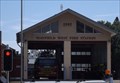 view gallery view gallery NE2.9 km NE2.9 km
| Mayfield West Fire Station in Firehouses On a main arterial road to Newcastle is this Firehouse, which covers a large industrial area, as well as the residential suburbs. posted by: Grahame Cookie location: New South Wales, Australia date approved: 01/16/2018 last visited: never |
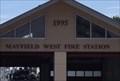 view gallery view galleryNE2.9 km |  1995 - Mayfield West Fire Station, NSW, Australia 1995 - Mayfield West Fire Station, NSW, Australia
in Dated Buildings and Cornerstones This double-bay, brick building, with roller doors at the front, and rear of the building, holds the two Fire Fighting vehicles of the Mayfield West Fire Station. posted by: Grahame Cookie location: New South Wales, Australia date approved: 01/15/2018 last visited: never |
 view gallery view gallerySE2.9 km |  New Lambton Branch Library, New Lambton, NSW, Australia New Lambton Branch Library, New Lambton, NSW, Australia
in Libraries New Lambton Branch Library, New Lambton, NSW, Australia posted by: Pensive Travellers location: New South Wales, Australia date approved: 06/28/2008 last visited: 11/10/2016 |
 view gallery view galleryS2.9 km |  John Hunter Hospital, Lambton Heights, Newcastle, NSW, Australia John Hunter Hospital, Lambton Heights, Newcastle, NSW, Australia
in Helicopter Landing Pads This helipad is at John Hunter Hospital, the principal referral centre and hospital for Newcastle, Lake Macquarie and Northern New South Wales. posted by: Grahame Cookie location: New South Wales, Australia date approved: 11/11/2015 last visited: never |
 view gallery view galleryS3.1 km |  Ronald McDonald House, Newcastle, NSW, Australia Ronald McDonald House, Newcastle, NSW, Australia
in Ronald McDonald Houses Newcastle's Ronald McDonald House is located in a peaceful bushland setting on the same campus as John Hunter Hospital. Don't expect convenient parking (unless a 'resident'). posted by: Grahame Cookie location: New South Wales, Australia date approved: 12/03/2014 last visited: never |
 view gallery view galleryW3.2 km | ALDI Store - Wallsend, NSW, Australia in ALDI Stores This is an ALDI store set within a 'Stockland Mall' shopping centre. Wheel chair friendly access. This store opened some time in 2001 - so I was told. posted by: Grahame Cookie location: New South Wales, Australia date approved: 12/05/2016 last visited: never |
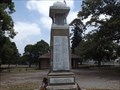 view gallery view galleryW3.2 km |  Wallsend Soldiers Memorial - Wallsend, NSW, Australia Wallsend Soldiers Memorial - Wallsend, NSW, Australia
in World War I Memorials and Monuments This tall, stone, relocated monument for World War One, is in Wallsend Park. posted by: Grahame Cookie location: New South Wales, Australia date approved: 11/22/2022 last visited: never |
|