 view gallery view gallery E2.7 km E2.7 km
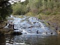
|   Ellenborough River Cascades - Elands, NSW, Australia Ellenborough River Cascades - Elands, NSW, Australia
in Waterfalls This is a lovely rocky Cascade just a few kilometres above the majestic Ellenborough Falls. posted by:  Grahame Cookie Grahame Cookie location: New South Wales, Australia date approved: 03/31/2024 last visited: never |
![Image for Ellenborough Falls [NSW, Australia]](https://img.geocaching.com/waymarking/small/1a81b5b3-da15-432c-82bf-633e1852498e.jpg) view gallery view galleryE5.1 km |  Ellenborough Falls [NSW, Australia] Ellenborough Falls [NSW, Australia]
in Wikipedia Entries This horsetail waterfall flows over the Bulga Plateau at Elands. posted by: Grahame Cookie location: New South Wales, Australia date approved: 03/25/2024 last visited: never |
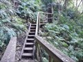 view gallery view galleryE5.6 km |  Ellenborough Falls, Base - Elands, NSW, Australia Ellenborough Falls, Base - Elands, NSW, Australia
in Outdoor Stairways The base of Ellenborough Falls is some 200m below the head of the horsetail waterfall. posted by: Grahame Cookie location: New South Wales, Australia date approved: 03/31/2024 last visited: never |
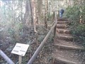
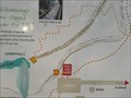 view gallery view galleryE5.6 km |  Ellenborough Falls - You are here - Elands, NSW, Australia Ellenborough Falls - You are here - Elands, NSW, Australia
in 'You Are Here' Maps This information sign near the car park shows where you are at the trails of Ellenborough Falls. posted by: Grahame Cookie location: New South Wales, Australia date approved: 03/31/2024 last visited: never |
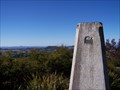
 view gallery view galleryE5.6 km |  Ellenborough Falls Lookout - Elands, NSW, Australia Ellenborough Falls Lookout - Elands, NSW, Australia
in Scenic Roadside Look-Outs A pleasant country drive onto the Bulga Plateau will get you to a simple ramp to the Falls Ellenborough Lookout. posted by: Grahame Cookie location: New South Wales, Australia date approved: 04/01/2024 last visited: never |
 view gallery view galleryE5.6 km |  The Knoll - Ellenborough Falls - Elands, NSW, Australia The Knoll - Ellenborough Falls - Elands, NSW, Australia
in Hiking and walking trailheads This dirt path divides to give the option of 'Bottom of the Falls', or 'The Knoll' outlook. posted by: Grahame Cookie location: New South Wales, Australia date approved: 03/30/2024 last visited: never |
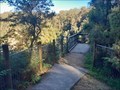
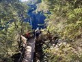
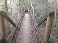 view gallery view galleryE5.8 km |  Ellenborough Falls/The Knoll Lookout - Elands, NSW, Australia Ellenborough Falls/The Knoll Lookout - Elands, NSW, Australia
in Hiking Path Footbridges This wooden footbridge gives access to the Knoll Lookout to the Ellenborough Falls. posted by: Grahame Cookie location: New South Wales, Australia date approved: 04/10/2024 last visited: never |
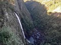 view gallery view galleryE5.8 km | Ellenborough Falls - Elands, NSW, Australia in Waterfalls This spectacular Waterfall is a little off the regular 'track', but worth it!! posted by: Grahame Cookie location: New South Wales, Australia date approved: 03/21/2024 last visited: never |
 view gallery view galleryE5.8 km |  Ellenborough Falls/The Knoll Lookout - Elands, NSW, Australia Ellenborough Falls/The Knoll Lookout - Elands, NSW, Australia
in Scenic Overlooks This wood platform is reached by a (T2½) 10 minute walk on a dirt track to this overlook of a great waterfall! posted by: Grahame Cookie location: New South Wales, Australia date approved: 03/21/2024 last visited: never |
 view gallery view gallery SE6.1 km SE6.1 km
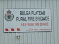
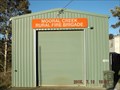
|  Bulga Plateau Rural Fire Brigade Bulga Plateau Rural Fire Brigade
in Firehouses The two buildings are for the volunteer fire fighters of the Elands region of the Bulga Plateau. posted by: Grahame Cookie location: New South Wales, Australia date approved: 03/02/2024 last visited: never |
 view gallery view gallery NW6.4 km NW6.4 km
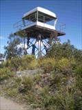
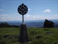
|  Kaoaraoa Kaoaraoa
in Australian Trig Points This Trig has a fire tower built on top. It's in a great area of State Forest and National Parks, accessible by 2wd. posted by: *socks* location: New South Wales, Australia date approved: 10/27/2008 last visited: 10/24/2014 |
 view gallery view gallery S11.7 km S11.7 km
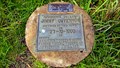
|  Capture of Jimmy Governor - Wingham, NSW Capture of Jimmy Governor - Wingham, NSW
in Australian Historical Markers This marker is to be found alongside Bobin Creek Road about 26 km. north northwest of the town of Wingham in NSW. posted by: T0SHEA location: New South Wales, Australia date approved: 12/29/2014 last visited: 01/07/2015 |
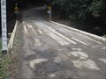 view gallery view galleryS12.6 km |  Bulga Rd Plank Bridge - Bobin, NSW, Australia Bulga Rd Plank Bridge - Bobin, NSW, Australia
in Plank Roads Where Bulga Road crosses Bobin Creek, on the Mid-North Coast of NSW, is a wooden plank bridge. posted by:  MVMTBiker MVMTBiker location: New South Wales, Australia date approved: 01/06/2018 last visited: 07/11/2016 |
 view gallery view gallerySE16.4 km |  Killabakh Mountain, Manning Valley, NSW, Australia Killabakh Mountain, Manning Valley, NSW, Australia
in Mountain Summits At 867 m this is the highest mountain of the Manning Valley, and requires about a four hour (return) walk on an unmaintained access trail for 75% of the way, with a rough track to the summit. posted by: Grahame Cookie location: New South Wales, Australia date approved: 08/30/2015 last visited: never |
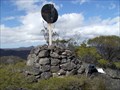
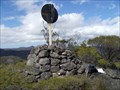 view gallery view gallerySE16.4 km |  Mt Killabakh, Manning Valley, NSW, Australia Mt Killabakh, Manning Valley, NSW, Australia
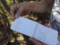
in Summit Registers While Mt Killabakh is 'only' 867 m high it is a well-worthwhile hike of ~4 km each way to see the views over the Manning Valley to the South.
The more 'official' register is the 100mm poly pipe with screw caps, (also an older tennis ball container). posted by: Grahame Cookie location: New South Wales, Australia date approved: 12/20/2014 last visited: never |
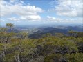 view gallery view gallerySE16.4 km | Killabakh trig, Manning Valley, NSW in Scenic Overlooks At an elevation of 867 m this is the highest peak in the Manning Valley. A bit of a walk to get to it tho. posted by: Grahame Cookie location: New South Wales, Australia date approved: 10/26/2014 last visited: never |
 view gallery view gallerySE16.4 km | Killabakh trig, Manning Valley, NSW in Australian Trig Points This is NOT an easy trig to get to, and definitely NOT a drive by. Be prepared for a couple hours of walk. BUT, WELL worth the EFFORT. Official Code: TS2716 posted by: Grahame Cookie location: New South Wales, Australia date approved: 11/29/2014 last visited: never |
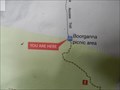 view gallery view galleryE17.2 km | Rawson Falls Walk, Start - You are here - Elands, NSW, Australia in 'You Are Here' Maps This map is next to the covered Boorganna picnic area table near the car park. posted by: Grahame Cookie location: New South Wales, Australia date approved: 03/02/2024 last visited: never |
 view gallery view gallerySE17.7 km | Mooral Creek Rural Fire Brigade in Firehouses Mooral Creek Rural Fire Brigade is a small, but vital community organisation powered by local volunteers. With the isolation of their area they are often the first attenders even for house fires. posted by: Grahame Cookie location: New South Wales, Australia date approved: 07/20/2015 last visited: never |
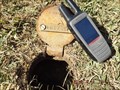 view gallery view gallerySE17.7 km |  PM 161765, Mooral Creek, NSW PM 161765, Mooral Creek, NSW
in Australia/NZ Benchmarks This is a steel, round-lidded survey marker, designated as a PM 161765, which is stamped on a metal plate. There is a section of 'star-picket' in the box to identify the required spot. You may require a lever to open the lid for your photo. posted by: Grahame Cookie location: New South Wales, Australia date approved: 11/29/2015 last visited: never |
 view gallery view galleryE18.8 km | Innes G.S., Comboyne, NSW in Australian Trig Points Set on the Comboyne plateau, in a cow paddock, is this concrete pedestal trig surrounded by LONG kikuyu grass. Official Code: TS6070; Official Name: Innes posted by: Grahame Cookie location: New South Wales, Australia date approved: 08/20/2017 last visited: never |
 view gallery view galleryE19.2 km | Donkin trig, Mt Gibraltar, (Comboyne), NSW in Australian Trig Points This is one of the higher peaks of the northern side of the Manning Valley. Official Code: TS5535; Height, from Bobin map - 853 metres posted by: Grahame Cookie location: New South Wales, Australia date approved: 11/06/2016 last visited: never |
 view gallery view gallerySE21.9 km | Mount Goonook Log Book, Yarratt Forest, NSW, Australia in Summit Registers This is NOT an easy place to get to, but you certainly appreciate the views from this summit. Probably Terrain 3½ posted by: Grahame Cookie location: New South Wales, Australia date approved: 11/20/2017 last visited: never |
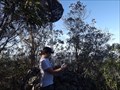 view gallery view gallerySE21.9 km | Goonook trig, Koppin Yarratt Forest, NSW in Australian Trig Points After a steep, 'Terrain 4' scramble and climb you will find stone cairn, and wooden post trig, with GREAT VIEWS. Official Name: Goonook; Official Code: TS2266; Elevation: 436 metres. posted by: Grahame Cookie location: New South Wales, Australia date approved: 11/16/2017 last visited: never |
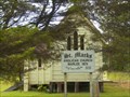 view gallery view galleryS23.2 km |  St Marks Anglican Church, Marlee, NSW, Australia St Marks Anglican Church, Marlee, NSW, Australia
in This Old Church The St Marks Anglican Church at Marlee was built in 1874; and such is one of the oldest original church buildings of the Manning Valley (on the Mid North Coast of NSW). posted by: Grahame Cookie location: New South Wales, Australia date approved: 03/20/2016 last visited: never |
|