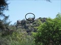
 view gallery view gallery SW4.7 km SW4.7 km
|   Hippo Crossing Hippo Crossing
in Uncommon Crossing Signs On either side of Tzaneen dam (on the road R36/R71) there is a hippo crossing sign from either direction. posted by:  funsigns funsigns location: Limpopo, South Africa date approved: 04/21/2024 last visited: never |
 view gallery view gallery SE58.3 km SE58.3 km
|  Chisomo Safari Camp - Hoedspruit, South Africa Chisomo Safari Camp - Hoedspruit, South Africa
in Lodge-Style Accommodations Chisomo Safari Camp has 22 tents overlooking the Makutsi River, tucked deep in the Big Five Karongwe Game Reserve in Limpopo, South Africa posted by: denben location: Limpopo, South Africa date approved: 12/03/2013 last visited: never |
 view gallery view gallerySE58.3 km |  'Mampoer Mampoer' by John Edmond - Chisomo Safari Camp - Hoedspruit, Limpopo, South Africa 'Mampoer Mampoer' by John Edmond - Chisomo Safari Camp - Hoedspruit, Limpopo, South Africa
in Immortalized in Lyrics Chisomo Safari Camp has 22 tents overlooking the Makutsi River, tucked deep in the Big Five Karongwe Game Reserve in Limpopo, South Africa posted by: denben location: Limpopo, South Africa date approved: 01/31/2023 last visited: never |
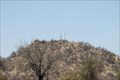
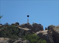
 view gallery view gallerySE92.9 km |  JONKMANSSPRUIT 2430-136 JONKMANSSPRUIT 2430-136
in Southern African Trig Beacons This beacon is on top of a small hill alongside the R527 near Hoedspruit. posted by:  Fish Eagle Fish Eagle location: Limpopo, South Africa date approved: 02/17/2013 last visited: 08/25/2021 |
 view gallery view gallery E98 km E98 km
| VERA (2331-5) in Southern African Trig Beacons Roadside cache near Palaborwa on R 71 posted by: Eksteen location: Mpumalanga, South Africa date approved: 10/22/2019 last visited: 10/22/2019 |
 view gallery view gallerySE108 km |  Mpumalanga's Panorama Route - The Three Rondavels - Mpumalanga, South Africa Mpumalanga's Panorama Route - The Three Rondavels - Mpumalanga, South Africa
in National Scenic Byways The Three Rondavels on Mpumalanga’s Panorama Route give a spectacular view over the Blyde River Canyon. Shaped like traditional African beehive huts, the Three Rondavels form three huge pinnacles of rock rising above the canyon below. posted by: denben location: Mpumalanga, South Africa date approved: 11/21/2013 last visited: 11/02/2019 |
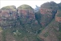 view gallery view gallerySE108 km |  Three Rondavels - Mpumalanga, South Africa Three Rondavels - Mpumalanga, South Africa
in Scenic Overlooks The Three Rondavels on Mpumalanga’s Panorama Route give a spectacular view over the Blyde River Canyon. Shaped like traditional African beehive huts, the Three Rondavels form three huge pinnacles of rock rising above the canyon below. posted by: denben location: Mpumalanga, South Africa date approved: 11/19/2013 last visited: 11/02/2019 |
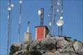 view gallery view gallerySE109.8 km | MARIEPSKOP 2430-37 in Southern African Trig Beacons Near Hoedspruit in Limpopo province RSA. A must visit Stunning up there posted by: Eksteen location: Limpopo, South Africa date approved: 05/07/2015 last visited: 07/28/2015 |
 view gallery view galleryE113.1 km | PIENE 2331-7 in Southern African Trig Beacons At Masorini Historic site in the Kruger National Park posted by: Fish Eagle location: Limpopo, South Africa date approved: 11/17/2017 last visited: 10/10/2019 |
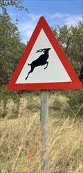 view gallery view gallerySE113.9 km | Kudu Crossing in Uncommon Crossing Signs On Argyle road to and from Thornybush Private Game Reserve in the greater Kruger Park area are crossing signs for Kudu and other antelope. posted by: funsigns location: Limpopo, South Africa date approved: 04/21/2024 last visited: never |
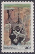
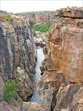
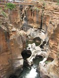
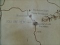 view gallery view gallerySE117.6 km |  You Are Here at Bourke's Luck Potholes - Mpumalanga, South Africa You Are Here at Bourke's Luck Potholes - Mpumalanga, South Africa
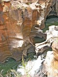
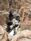
in 'You Are Here' Maps The Blyde River Canyon Nature Reserve contains the Bourke's Luck Potholes... which includes several natural arches amid the kettles created by natural plunge pools. posted by: Metro2 location: Mpumalanga, South Africa date approved: 11/18/2014 last visited: 10/10/2019 |
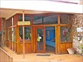 view gallery view gallerySE117.6 km |  Bourke's Luck Potholes Visitor Center - Mpumalanga, South Africa Bourke's Luck Potholes Visitor Center - Mpumalanga, South Africa
in Tourist Information Centers - Visitor Centers Bourke's Luck Potholes Visitor Center is located on the Panorama Route in Mpumalanga Province in eastern South Africa, near Graskop on the R532. posted by: denben location: Mpumalanga, South Africa date approved: 01/25/2023 last visited: never |
 view gallery view gallerySE117.6 km |  Bourke's Luck Potholes - Mpumalanga, South Africa Bourke's Luck Potholes - Mpumalanga, South Africa
in Wikipedia Entries Bourke's Luck Potholes is one of the most phenomenal geological phenomenon in South Africa, Mpumalanga, South Africa. posted by: denben location: Mpumalanga, South Africa date approved: 01/24/2023 last visited: never |
 view gallery view gallerySE117.6 km | 'Mamba in Mpumalanga' by docsoul - Mpumalanga, South Africa in Immortalized in Lyrics Mpumalanga is a province of South Africa. The name means "East", or literally "The Place Where the Sun Rises" in the Swazi, Xhosa, Ndebele and Zulu languages. Mpumalanga lies in eastern South Africa, bordering Eswatini and Mozambique. posted by: denben location: Mpumalanga, South Africa date approved: 01/26/2023 last visited: never |
 view gallery view gallerySE117.6 km |  Multimillion-rand Blyde River Canyon project goes ahead despite lawsuit - Mpumalanga, South Africa Multimillion-rand Blyde River Canyon project goes ahead despite lawsuit - Mpumalanga, South Africa
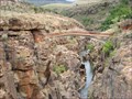
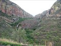
in News Article Locations The Blyde River Canyon is a 26km long Canyon that is part of the Blyde River Canyon Nature Reserve in Mpumalanga, South Africa. It is a "green canyon" which is dominated by subtropical vegetation. posted by: denben location: Mpumalanga, South Africa date approved: 01/25/2023 last visited: never |
 view gallery view gallerySE117.6 km |  Blyde River Canyon Nature Reserve - Mpumalanga, South Africa Blyde River Canyon Nature Reserve - Mpumalanga, South Africa
in Official Local Tourism Attractions The Blyde Canyon Reserve's most spectacular stretch is the Blyde River Canyon which is the third largest canyon in the world. It offers visitors a remarkable experience due to many well-positioned viewpoints along the canyon. posted by: denben location: Mpumalanga, South Africa date approved: 11/18/2013 last visited: 11/02/2019 |
 view gallery view gallerySE117.6 km |  Blyde River Canyon - Mpumalanga, South Africa Blyde River Canyon - Mpumalanga, South Africa
in Places of Geologic Significance The Blyde River Canyon is a significant natural feature of South Africa, located in Mpumalanga, and forming the northern part of the Drakensberg escarpment. posted by: denben location: Mpumalanga, South Africa date approved: 11/17/2013 last visited: 11/02/2019 |
 view gallery view gallerySE117.6 km |  Bourke's Luck Potholes - Mpumalanga, South Africa Bourke's Luck Potholes - Mpumalanga, South Africa
in Philatelic Photographs Bourke's Luck Potholes is one of the most phenomenal geological phenomenon in South Africa, Mpumalanga, South Africa. posted by: denben location: Mpumalanga, South Africa date approved: 02/04/2023 last visited: never |
 view gallery view gallerySE117.6 km |  Blyde River Canyon Nature Reserve - Mpumalanga, South Africa Blyde River Canyon Nature Reserve - Mpumalanga, South Africa
in State/Provincial Parks The Blyde Canyon Reserve's most spectacular stretch is the Blyde River Canyon which is the third largest canyon in the world. It offers visitors a remarkable experience due to many well-positioned viewpoints along the canyon. posted by: denben location: Mpumalanga, South Africa date approved: 11/16/2013 last visited: 11/02/2019 |
 view gallery view gallerySE117.6 km |  Blyde River Canyon - Mpumalanga, South Africa Blyde River Canyon - Mpumalanga, South Africa
in Satellite Imagery Oddities The Blyde River Canyon is a 26km long Canyon located in Mpumalanga, South Africa. It is one of the larger canyons on Earth but much smaller than those of Asia, the Grand Canyon and the Fish River Canyon. posted by: denben location: Mpumalanga, South Africa date approved: 01/25/2023 last visited: never |
 view gallery view gallerySE117.6 km |  The Drakensberg Mountains - Mpumalanga, South Africa The Drakensberg Mountains - Mpumalanga, South Africa
in 1000 Places to See Before You Die The Drakensberg Mountains of South Africa is a 200-kilometre-long mountainous wonderland and world heritage site. posted by: denben location: Mpumalanga, South Africa date approved: 11/26/2013 last visited: 11/02/2019 |
 view gallery view gallerySE117.8 km |  Blyde River Canyon Lucky 7 - Mpumalanga, South Africa Blyde River Canyon Lucky 7 - Mpumalanga, South Africa
in Lucky 7 The center point of Blyde River Canyon Lucky 7 is on the Bourke's Luck Potholes trail. Our 8 waymarks are within 0,1 miles from this center point with a tally of 16. posted by: denben location: Mpumalanga, South Africa date approved: 01/25/2023 last visited: never |
 view gallery view gallerySE118 km |  Blyde River Canyon - Mpumalanga, South Africa Blyde River Canyon - Mpumalanga, South Africa
in Drawing Waymarks The Blyde River Canyon is a 26km long Canyon that is part of the Blyde River Canyon Nature Reserve in Mpumalanga, South Africa. It is a "green canyon" which is dominated by subtropical vegetation. posted by: denben location: Mpumalanga, South Africa date approved: 10/08/2023 last visited: never |
 view gallery view gallerySE118 km |  Blyde River - Mpumalanga, South Africa Blyde River - Mpumalanga, South Africa
in National Wild and Scenic Rivers Blyde River is a river in the Mpumalanga and Limpopo provinces of South Africa. Blyde River Canyon is the Blyde River most spectacular stretch. posted by: denben location: Mpumalanga, South Africa date approved: 12/10/2013 last visited: 10/10/2019 |
 view gallery view gallerySE118 km |  CONFLUENCE - River Treur - River Blyde - South Africa CONFLUENCE - River Treur - River Blyde - South Africa
in River Origins, Destinations and Confluences The River Treur meets River Blyde at the famous Bourke's Luck Potholes at the Blyde River Canyon in Mpumalanga, South Africa. posted by: denben location: Mpumalanga, South Africa date approved: 11/21/2013 last visited: 10/10/2019 |
|