 view gallery view gallery E6.3 km E6.3 km
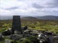
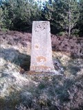
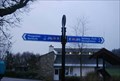
|   Sawel, Sperrin Mountains, Co. Derry Sawel, Sperrin Mountains, Co. Derry
in U.K. and Ireland Trigpoints Trig Pillar at the summit of Sawel Mountain (678m) posted by:  dino-irl dino-irl location: Ireland date approved: 10/29/2007 last visited: 07/13/2009 |
 view gallery view gallery SE17.1 km SE17.1 km
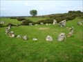
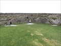
|  Beaghmore - Northern Ireland Beaghmore - Northern Ireland
in Wikipedia Entries Beaghmore is a complex of early Bronze Age megalithic features, stone circles and cairns, 8.5 miles north west of Cookstown, County Tyrone in Northern Ireland. posted by:  Noe1 Noe1 location: Ulster, Ireland date approved: 11/04/2014 last visited: 06/03/2021 |
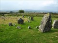 view gallery view gallerySE17.1 km |  Beaghmore Stone Circles - Northern Ireland Beaghmore Stone Circles - Northern Ireland
in Megalithic Monuments Beaghmore is a complex of early Bronze Age megalithic features, stone circles and cairns, 8.5 miles north west of Cookstown, County Tyrone in Northern Ireland. posted by: Noe1 location: Ulster, Ireland date approved: 11/04/2014 last visited: 06/03/2021 |
 view gallery view gallery NW24.1 km NW24.1 km
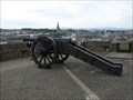
|  Cannons on the Walls of Derry, Derry, Northern Ireland, UK Cannons on the Walls of Derry, Derry, Northern Ireland, UK
in Static Artillery Displays Cannons used during the Siege of Derry (Irish: Léigear Dhoire) in 1689. posted by: Noe1 location: United Kingdom date approved: 06/15/2012 last visited: never |
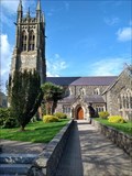
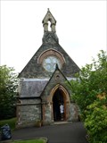 view gallery view galleryNW24.3 km |  St. Augustine's Church - Derry, Northern Ireland St. Augustine's Church - Derry, Northern Ireland
in Anglican and Episcopal Churches A neo-Gothic church of 1872. posted by: Noe1 location: United Kingdom date approved: 11/11/2014 last visited: never |
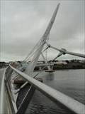 view gallery view galleryNW24.3 km |  The Peace Bridge The Peace Bridge
in Pedestrian Suspension Bridges A tribute to the peace process in Northern Ireland, this bridge spans the Foyle River from the town of Derry to the former British Barracks. The river is the dividing line between the Republic of Ireland and the United Kingdom. posted by: DnRseekers location: Ulster, Ireland date approved: 09/13/2012 last visited: 07/18/2012 |
 view gallery view galleryNW24.3 km | The Peace Bridge, Derry, Ireland in Wikipedia Entries Open in 2011, this unique pedestrian suspension bridge crosses the Foyle River uniting the Republic of Ireland with the United Kingdom. posted by: DnRseekers location: Ulster, Ireland date approved: 09/15/2012 last visited: 08/15/2016 |
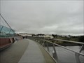 view gallery view galleryNW24.3 km |  One Millionth Crossing of the Peace Bridge One Millionth Crossing of the Peace Bridge
in News Article Locations Opened in 2011, the Derry Peace Bridge has attracted one million pedestrians and cyclists in just over one year. posted by: DnRseekers location: Ulster, Ireland date approved: 09/12/2012 last visited: 07/18/2012 |
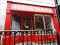 view gallery view galleryNW24.3 km |  Foyle Books Foyle Books
in Used Book Stores Located on magazine street in the Craft Village, this store is "the ultimate" place to find a great read! posted by: DnRseekers location: Ulster, Ireland date approved: 09/13/2012 last visited: 07/18/2012 |
 view gallery view galleryNW24.5 km | Free Derry Corner - Derry, Northern Ireland in Wikipedia Entries Free Derry Corner is a historical landmark in the Bogside neighbourhood of Derry, Northern Ireland. posted by: Noe1 location: Ulster, Ireland date approved: 11/04/2014 last visited: never |
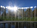
 view gallery view galleryNW24.5 km |  Hunger strike memorial in Bogside- Derry, Ulster, Northern Ireland Hunger strike memorial in Bogside- Derry, Ulster, Northern Ireland
in Civil Rights Memorials The H Block Hunger Strike Memorial in Derry, Northern Ireland posted by: Noe1 location: Ulster, Ireland date approved: 03/19/2013 last visited: 04/11/2014 |
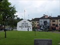 view gallery view galleryNW24.5 km | Bogside - Derry, Northern Ireland in Wikipedia Entries The Bogside (Irish: Taobh an Bhogaigh) is a Catholic neighbourhood outside the city walls of Derry, Northern Ireland. posted by: Noe1 location: Ulster, Ireland date approved: 11/04/2014 last visited: 04/11/2014 |
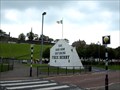
 view gallery view gallery SW25.1 km SW25.1 km
|  Omagh Bomb Memorial - Omagh Co Tyrone Omagh Bomb Memorial - Omagh Co Tyrone
in Disaster Memorials At 3.10 p.m. on Saturday afternoon, August 15, 1998, a car bomb exploded in a crowded shopping area of Omagh, Co Tyrone. posted by: Windsocker location: Ireland date approved: 12/28/2008 last visited: 10/19/2013 |
 view gallery view galleryNW29.8 km | Dooish Mountain, Raphoe. Co. Donegal in U.K. and Ireland Trigpoints An unmapped trigpoint at the top of Dooish Mountain (276m) near Raphoe. posted by: dino-irl location: Ulster, Ireland date approved: 04/25/2010 last visited: never |
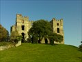 view gallery view gallery W30.6 km W30.6 km
|  Raphoe Castle Raphoe Castle
in Castles The ruins of Raphoe Castle, near the town of Raphoe, Ireland. posted by: Happy Paddlers location: Ireland date approved: 10/18/2010 last visited: never |
 view gallery view galleryNW30.6 km |  Grianan Aileach - County Donegal, Ireland Grianan Aileach - County Donegal, Ireland
in Historic Forts A beautifully preserved hillfort atop the 244 high Greenan Mountain at Inishowen in County Donegal, Ireland. posted by: flyingmoose location: Ulster, Ireland date approved: 06/29/2020 last visited: never |
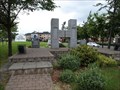
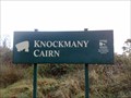 view gallery view gallery S39.8 km S39.8 km
| Knockmany Cairn in Megalithic Monuments Knockmany (Cnoc mBaine = 'the Hill of Queen Baine' the wife of the first century King Tuathal Techtmar) posted by: Windsocker location: Ireland date approved: 11/16/2008 last visited: 12/13/2009 |
 view gallery view gallerySE42.6 km |  Cycle Route 95 - Dungannon Lake Park Cycle Route 95 - Dungannon Lake Park
in Cycling Routes This traffic-free route is great for a family ride with young children. Dungannon Park, on the edge of Dungannon, is a beautifully kept area with a trout-fishing lake and lots of activities, and is wonderful for exploring by bike. posted by: Windsocker location: Ireland date approved: 03/03/2008 last visited: 06/22/2021 |
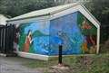 view gallery view gallerySE42.8 km |  Wise Woman - Dungannon Northern Ireland Wise Woman - Dungannon Northern Ireland
in Murals This is a large mural in Dungannon park Northern Ireland posted by: Windsocker location: Ireland date approved: 03/02/2008 last visited: 10/02/2013 |
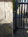 view gallery view gallery NE46.8 km NE46.8 km
| Cut Mark St Patrick's Church Gate, Coleraine, Northern Ireland in U.K. and Ireland Trigpoints St Patrick's Church of Ireland is in the town centre. posted by: elyob location: Ulster, Ireland date approved: 04/24/2022 last visited: 07/08/2023 |
 view gallery view galleryNE46.8 km | St. Patrick's Church - Coleraine, Northern Ireland in Anglican and Episcopal Churches St. Patrick's Church of Ireland is in the town centre. posted by: elyob location: Ulster, Ireland date approved: 05/20/2022 last visited: 07/08/2023 |
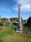 view gallery view galleryNE53.1 km |  Black Family Obelisk - Old Graveyard, Ballywillan, Northern Ireland Black Family Obelisk - Old Graveyard, Ballywillan, Northern Ireland
in Obelisks The Old Graveyard at Ballywillan is near Portrush. posted by: elyob location: Ulster, Ireland date approved: 05/03/2022 last visited: never |
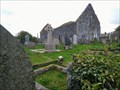 view gallery view galleryNE53.1 km |  Ballywillan Church Ruins - Ballywillan, Portrush, Northern Ireland Ballywillan Church Ruins - Ballywillan, Portrush, Northern Ireland
in Medieval Churches From many areas in the town of Portrush, the church ruins can be seen on the high ground to the south. posted by: elyob location: Ulster, Ireland date approved: 06/04/2022 last visited: never |
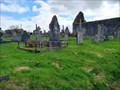 view gallery view galleryNE53.1 km |  Old Graveyard, Ballywillan, near Portrush, Northern Ireland Old Graveyard, Ballywillan, near Portrush, Northern Ireland
in Worldwide Cemeteries Posted co-ordinates are for the only entrance to the old graveyard. It is a gate on the south side of Magheraboy Road. posted by: elyob location: Ulster, Ireland date approved: 04/30/2022 last visited: never |
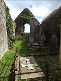 view gallery view galleryNE53.1 km |  Ballywillan Church Ruins - Ballywillan, near Portrush, Northern Ireland Ballywillan Church Ruins - Ballywillan, near Portrush, Northern Ireland
in Preserved Architectural Remnants and Ruins Use the car park at the modern cemetery. posted by: elyob location: Ulster, Ireland date approved: 05/10/2022 last visited: never |
|