 view gallery view gallery S2.1 km S2.1 km
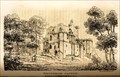
|   Brougham Castle by William Green c 1820 - Brougham Castle, Brougham, Cumbria, UK Brougham Castle by William Green c 1820 - Brougham Castle, Brougham, Cumbria, UK
in Paintings Then and Now An engraving of Brougham Castle by William Green taken from the opposite bank of the river. posted by:  bill&ben bill&ben location: North West England, United Kingdom date approved: 09/08/2013 last visited: 03/24/2022 |
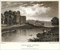 view gallery view galleryS2.1 km | Brougham Castle, Cumbria, UK by Henry Gastineau c 1823 – Brougham Castle, Brougham, Cumbria, UK in Paintings Then and Now An engraving of Brougham Castle taken from the adjacent river bank. posted by: bill&ben location: North West England, United Kingdom date approved: 09/08/2013 last visited: 03/24/2022 |
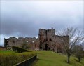 view gallery view galleryS2.1 km |  Brougham Castle, Brougham, Cumbria, UK Brougham Castle, Brougham, Cumbria, UK
in Castles A castle originally belonging to the Clifford family posted by: bill&ben location: North West England, United Kingdom date approved: 04/28/2013 last visited: 03/24/2022 |
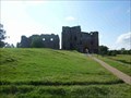 view gallery view galleryS2.1 km |  Brougham Castle, Brougham, Cumbria, England Brougham Castle, Brougham, Cumbria, England
in Wikipedia Entries Brougham Castle, Brougham, Cumbria, England posted by: The_Senior_Crabbes location: North West England, United Kingdom date approved: 08/31/2018 last visited: 03/24/2022 |
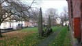
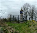 view gallery view galleryS2.3 km |  Countess Pillar, A66, Brougham, Cumbria, UK Countess Pillar, A66, Brougham, Cumbria, UK
in UK Historical Markers The Countess Pillar marks the place where Lady Anne Clifford, Countess of Dorset, bade farewell to her mother Margaret on 2 April 1616. posted by: bill&ben location: North West England, United Kingdom date approved: 04/28/2013 last visited: never |
 view gallery view gallery SE2.4 km SE2.4 km
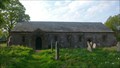
| Ninekirks, Cumbria in Wikipedia Entries Ninekirks is a grade 1 listed church. There has been a religious site here since Roman times. The church is no longer in regular use and in the care of the Church Preservation Trust. Open to the public. posted by: flipflopnick location: North West England, United Kingdom date approved: 05/23/2012 last visited: never |
 view gallery view gallerySE2.4 km |  Ninekirks Church Pews, Cumbria Ninekirks Church Pews, Cumbria
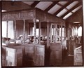
in Photos Then and Now Ninekirks is the colloquial name for St. Ninian's Church. This picture is inside the church showing the wooden stalls with pews and congregation. Looking to the east gable from just inside the main door. posted by: flipflopnick location: North West England, United Kingdom date approved: 05/23/2012 last visited: never |
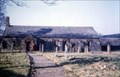 view gallery view gallerySE2.4 km | Ninekirks Church, Cumbria in Photos Then and Now Ninekirks church is a good photo opportunity as this early colour image shows. Looking north west down the gravel path to the church. Note person in red standing next to the porch. posted by: flipflopnick location: North West England, United Kingdom date approved: 05/23/2012 last visited: never |
 view gallery view gallery SW2.4 km SW2.4 km
|  Beacon Trail, Penrith, Cumbria Beacon Trail, Penrith, Cumbria
in Self Guided Walks and Trails The Beacon Trail starts in Sandgate, an open paved space which used to be a market and hiring area. The walk leads you up to the Beacon. The highpoint overlooking Penrith. Download dedicated PDF leaflet. posted by: flipflopnick location: North West England, United Kingdom date approved: 12/01/2012 last visited: never |
 view gallery view gallerySW2.4 km | Giant's Grave, Penrith, Cumbria in Photos Then and Now The Giant's Grave is beside St Andrew's Church in the centre of Penrith. Traditionally the grave is thought to be where Owen Cæsarius, king of Cumbria between 900 and 937 AD was buried. Looking east. posted by: flipflopnick location: North West England, United Kingdom date approved: 11/23/2012 last visited: never |
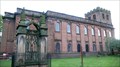 view gallery view gallerySW2.4 km |  St Andrew's Church, Penrith, Cumbria St Andrew's Church, Penrith, Cumbria
in This Old Church St. Andrew's is the Parish Church and a large Georgian building rebuilt in the years 1720 and 1722. The tower is all that remains from the original 13th Century church. posted by: flipflopnick location: North West England, United Kingdom date approved: 11/23/2012 last visited: never |
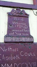
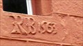 view gallery view gallerySW2.6 km |  1563 - Tudor House, Penrith, Cumbria 1563 - Tudor House, Penrith, Cumbria
in Dated Buildings and Cornerstones Tudor House is one of the oldest buildings in Penrith. Over the years it has appeared in many colours. Highlighted is the projecting porch. posted by: flipflopnick location: North West England, United Kingdom date approved: 11/26/2012 last visited: never |
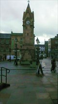
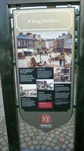
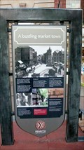 view gallery view gallerySW2.6 km | St Andrews Trail, Penrith, Cumbria in Self Guided Walks and Trails The St Andrews Trail starts at the Musgrave Monument and goes first to the parish church of St Andrews. From there the trail passes a total of 23 points in an area east of the centre of Penrith. Download dedicated PDF leaflet. posted by: flipflopnick location: North West England, United Kingdom date approved: 12/01/2012 last visited: never |
 view gallery view gallerySW2.6 km | Wordsworth Trail, Penrith, Cumbria in Self Guided Walks and Trails The Wordsworth Trail starts at Arnison's shop as Middlegate becomes Market Square. The route only visits 5 places. Without visiting the fifth point at the Beacon, this walk will only take 30 minutes. Download dedicated leaflet from link below. posted by: flipflopnick location: North West England, United Kingdom date approved: 12/05/2012 last visited: never |
 view gallery view gallerySW2.6 km | Corn Market Trail, Penrith, Cumbria in Self Guided Walks and Trails The Corn Market Trail starts at the Musgrave Monument in Market Place, in the centre of Penrith. The road to Corn Market leads off west from here. This is one of the shorter town trails. All on pavements and pedestrian areas. Download PDF leaflet. posted by: flipflopnick location: North West England, United Kingdom date approved: 12/01/2012 last visited: never |
 view gallery view gallery W2.6 km W2.6 km
| Musgrave Trail, Penrith, Cumbria in Self Guided Walks and Trails The Musgrave Trail starts outside the Tourist Information Centre, which is the entrance to Penrith Museum. One of many walks in Penrith. Download dedicated PDF Leaflet or purchase a pack of all trails from TIC. posted by: flipflopnick location: North West England, United Kingdom date approved: 12/01/2012 last visited: never |
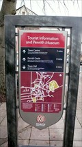 view gallery view galleryW2.6 km | Town Hall Trail, Penrith, Cumbria in Self Guided Walks and Trails The Town Hall Trail starts at the Tourist Information Centre on Middlegate and goes past 18 locations. All described in the leaflet pack available within. Download free PDF copy from link below. posted by: flipflopnick location: North West England, United Kingdom date approved: 12/05/2012 last visited: never |
 view gallery view gallerySW2.6 km | The Castle Trail, Penrith, Cumbria in Self Guided Walks and Trails The Castle Trail starts in the Corn Market near the Board & Elbow pub and proceeds in a loop passing 12 points of interest, with the train station the furthest point. Download free trail guide, or purchase a pack of all trails from TIC. posted by: flipflopnick location: North West England, United Kingdom date approved: 12/01/2012 last visited: never |
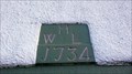 view gallery view gallerySW2.9 km | 1734 - 8 Kemplay Foot, Eamont Bridge, Cumbria in Dated Buildings and Cornerstones The road through Eamont Bridge is the ancient road to the north, now designated A6. There are many old buildings around the ancient crossing point of Eamont River. No. 8 is not a listed building. posted by: flipflopnick location: North West England, United Kingdom date approved: 12/10/2012 last visited: never |
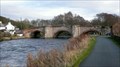
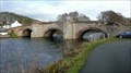 view gallery view gallerySW2.9 km |  Eamont Bridge, Cumbria Eamont Bridge, Cumbria
in Stone Bridges Eamont Bridge gives its name to the village and takes its name from the river Eamont which flows underneath. The first recorded bridge here is 1303. posted by: flipflopnick location: North West England, United Kingdom date approved: 12/11/2012 last visited: never |
 view gallery view gallerySW2.9 km | 1781 - Welcome Inn, Eamont Bridge, Cumbria in Dated Buildings and Cornerstones The Welcome Inn was one of the five former inns in Eamont Bridge. No longer trading, now a private house with the same name. Grade 2 listed building. posted by: flipflopnick location: North West England, United Kingdom date approved: 12/12/2012 last visited: never |
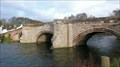 view gallery view gallerySW2.9 km |  Eamont Bridge, Cumbria Eamont Bridge, Cumbria
in Arch Bridges Eamont Bridge is the name of the village as well. Originally called just Bridge, eventually taking the name of the river, Eamont, flowing underneath. Grade 2 listed structure. posted by: flipflopnick location: North West England, United Kingdom date approved: 12/12/2012 last visited: never |
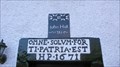 view gallery view gallerySW2.9 km | 1671 Bridge End, Eamont Bridge, Cumbria in Dated Buildings and Cornerstones Bridge End has two dated stones above the main door. The property is a rental cottage. Grade 2 listed building. posted by: flipflopnick location: North West England, United Kingdom date approved: 12/12/2012 last visited: never |
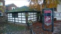
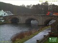 view gallery view gallerySW2.9 km |  Eamont Bridge Camera, Cumbria Eamont Bridge Camera, Cumbria
in Web Cameras Eamont Bridge web camera refreshes every 10 seconds and is looking at the upstream arches of Eamont Bridge. Looking east. The tarmac road in view leads to River Garth Guest House who host the camera. Timezone GMT posted by: flipflopnick location: North West England, United Kingdom date approved: 12/04/2012 last visited: never |
 view gallery view gallerySW3.1 km | Eamont Bridge in 1893, Cumbria in Photos Then and Now Eamont Bridge has always been an important crossing point. Not only the river Eamont, which formed the boundary between Westmorland and Cumberland but also from the south in to the wild north. Looking east and downstream. posted by: flipflopnick location: North West England, United Kingdom date approved: 12/12/2012 last visited: never |
|